| | Description | Data sources | Potential uses | Limitations | Further information | Download spatial information
Description
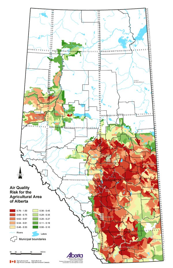
This map displays an assessment of air quality risk for the agricultural area of Alberta. Agricultural activities that may have some influence on air quality include manure production (odour) and cultivation intensity (particulate matter). The airsheds of the agricultural region of Alberta are considered to be uniform in their physical susceptibility to risk from agricultural activities. The classes shown on the map were ranked from 0 (lowest risk) to 1 (highest risk).
Data Sources
The air quality risk assessment procedure utilized 2001 Census of Agriculture data related to livestock numbers and tillage practices.
Soil Landscapes of Canada (SLC) Version 1.9 was used for this map. SLC polygons were created using existing soil survey information. Each polygon is described by a standard set of soil and land attributes that characterizes the soil landscapes found in each SLC polygon. Soils, landscapes and climate are the key natural resource factors that determine agricultural productivity, and the farms within a soil landscape unit usually have similar production characteristics.
Odour was considered directly correlated to manure production. Manure production was calculated for each SLC polygon from 2001 Census of Agriculture data collected about the numbers of all livestock raised in the province. Using research by Culley and Barnett (1984), Statistics Canada calculated the amount of manure produced by the total number of livestock. A formula that weighted the different livestock based on animal size and average manure output was used. The numbers of each type of livestock reported in the Census, multiplied by its manure factor, were totalled to give the total manure produced in tonnes. That value divided by the SLC area (square km) resulted in a ratio per unit area for each SLC (manure rating).
Particulate matter in the air was considered directly correlated to cultivation intensity. A cultivation rating based on frequency of cultivation used in various management systems was calculated. Data was collected during the 2001 Census of Agriculture. Census questions provided an estimate of the area of no till, conservation tillage, conventional tillage and summerfallow on farms in Alberta. Custom processing of the data by Statistics Canada yielded the percent of the land within each SLC polygon associated with the four management systems.
The cultivation rating is a measure of the cultivation intensity with management systems having a greater frequency of cultivation weighted higher. The cultivation rating was calculated for each SLC by the following formula:
Cultivation rating = (% area in no till) x 1 + (% area in conservation tillage) x 2 + (% area in conventional tillage) x 3 + (% area in summerfallow) x 4
The manure rating and the cultivation rating were added, and the result was ranked from 0 to 1 to form the air quality risk factor for each SLC polygon as displayed on the map.
Potential Uses
Air quality risk is a useful measure for those concerned about health, safety and nuisance issues related to the quality of air in agricultural areas. Awareness of where agricultural activities related to livestock production and intensive cultivation are located may be useful for people with health or nuisance related concerns. Blowing soil can cause respiratory problems and can reduce visibility on roads and highways. Dust from farm traffic can be a concern during peak agricultural activity, such as harvesting or manure hauling. Frequent strong odours can be an unpleasant nuisance for neighbours.
In areas of greater air quality risk, environmental farm planning can help to address the issues and provide solutions. Practices including pen/barn maintenance, method of manure application, manure application timing, manure storage, composting, adjusting feed rations and reducing or eliminating tillage can be looked at in an environmental farm plan.
Limitations
Since the airsheds of the agricultural region of Alberta were considered to be uniform in their physical susceptibility to risk from agricultural activities, no physical characteristics were included to determine the air quality risk factor. Site-specific characteristics may be found, but they are not applicable at the regional level displayed on this map. Landowners can locate their own property on the map and identify the potential relative risks, but then must assess and evaluate their own conditions and determine the beneficial management practices (BMPs) to address the risk.
Further Information
Alberta Agriculture and Food (AF) provides information about air quality including odour concerns and beneficial management practices. From the AF website, use the topic bar on the left and follow: Soil/Water/Air, Air and Odours & Dust. www.agric.gov.ab.ca
Canadian Soil Information System (CanSIS) provides soils information and data including information about SLCs. From the CanSIS website under Data, click on Soil Landscapes on the left side topic bar. http://sis.agr.gc.ca/cansis
2001 Census of Agriculture website expands on the use of the data collected. www.statcan.ca/english/agcensus2001
Culley, J.B. and Barnett, G.M. 1984. Land Disposal of Manure in Province of Quebec. Canadian Journal of Soil Science. 64:75-86.
Click on map for larger view
Download Spatial Information
Agricultural Land Resource Atlas of Alberta - Air Quality Risk for the Agricultural Area of Alberta
|
|