Agricultural Land Resource Atlas of Alberta - Organic Matter Content of Cultivated Soils of the Agricultural Area of Alberta


Download 248K pdf file ("pg_22_organic_matter.pdf")PDF
(248K)
     Subscribe to our free E-Newsletter, "Agri-News" (formerly RTW This Week)Agri-News
This Week


 Description | Data sources | Potential uses | Limitations | Further information | Download spatial information

Description

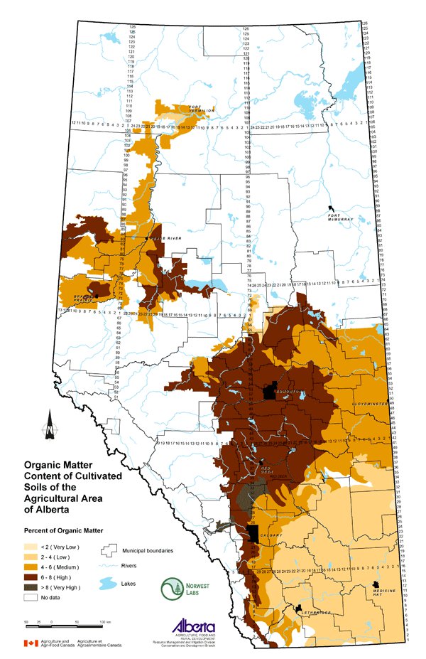
This map displays the percentage of organic matter in the surface layer of cultivated soils in the agricultural region of Alberta. Soil organic matter (SOM) is derived primarily from the decomposition of plant biomass. SOM improves both the physical and chemical properties of soil and has beneficial effects on agricultural soil quality. SOM is reported on the map as a percentage using the following classes: less than 2 (very low), 2 to 4 (low), 4 to 6 (medium), 6 to 8 (high) and greater than 8 (very high).

Data Sources

Data used in this map comes from Norwest Labs and was presented in a study conducted by Norwest Labs and Alberta Agriculture and Food (AF). The study looked at distribution of soil fertility parameters, including SOM, on an ecodistrict basis. Ecodistricts are land areas that "are characterized by distinct assemblages of landform, relief, surficial geological material, soil, water bodies, vegetation and land uses" (Ecological Stratification Working Group, 1995).

The Norwest Labs database represented 77,962 records from 1993 to 1997. Producers submitted soil samples taken at a depth of 0 to 30 cm. An average SOM value was calculated for each ecodistrict and then assigned to classes ranging from very low to very high.

Potential Uses

Since SOM is an important factor influencing soil quality and agricultural productivity, it is useful to know how SOM levels vary. Awareness of the factors that affect SOM levels may help producers adopt beneficial management practices. Land use practices including increased use of forages in crop rotations, tillage and residue management affect SOM levels.

Limitations

The data used is an average of soil samples taken within each ecodistrict. Assessment of SOM is very site-specific due to factors that include soil moisture levels, soil texture and climate. SOM varies across the landscape. This map should be viewed as a characterization of SOM levels across the province.

Further Information

AF has additional information about the importance and management of SOM. From the AF website, use the topic bar on the left and follow: Soil/Water/Air, Soil Fertility and Nutrient Management. www.agric.gov.ab.ca

Keyes, D., Cannon, K. and Kryzanowski, L. 1999. Spatial Relationships Between Soil Fertility Parameters and Ecological Landforms. Proceedings of the 36th Annual Alberta Soil Science Workshop. February 16-18, 1999. Calgary, Alberta.

Ecological Stratification Working Group. 1995. A National Ecological Framework for Canada. Agriculture and Agri-Food Canada, Research Branch, Centre for Land and Biological Resources Research and Environment Canada, State of Environment Directorate, Ecozone Analysis Branch, Ottawa/Hull. 125pp. One map (scale 1:7 500 000).

Click on map for larger view

Download Spatial Information

Agricultural Land Resource Atlas of Alberta - Organic Matter Content of Cultivated Soils of the Agricultural Area of Alberta


Other Documents in the Series

 
  Agricultural Land Resource Atlas of Alberta - Preface
Agricultural Land Resource Atlas of Alberta - Municipal Districts and Counties of Alberta
Agricultural Land Resource Atlas of Alberta - Township Grid System of Alberta
Agricultural Land Resource Atlas of Alberta - Annual Total Precipitation of Alberta, 1971 to 2000
Agricultural Land Resource Atlas of Alberta - Frost-free Period of Alberta, 1971 to 2000
Agricultural Land Resource Atlas of Alberta - Annual Solar Radiation of Alberta, 1971 to 2000
Agricultural Land Resource Atlas of Alberta - Areal Extent of Wetlands in the Agricultural Area of Alberta
Agricultural Land Resource Atlas of Alberta - Soil Groups of Alberta
Agricultural Land Resource Atlas of Alberta - Soil Texture of the Agricultural Area of Alberta
Agricultural Land Resource Atlas of Alberta - Saline Soils of the Agricultural Area of Alberta
Agricultural Land Resource Atlas of Alberta - Solonetzic Soils of the Agricultural Area of Alberta
Agricultural Land Resource Atlas of Alberta - Organic Matter Content of Cultivated Soils of the Agricultural Area of Alberta - Current Document
Agricultural Land Resource Atlas of Alberta - Organic Soils of the Agricultural Area of Alberta
Agricultural Land Resource Atlas of Alberta - Water Erosion Risk of the Agricultural Area of Alberta
Agricultural Land Resource Atlas of Alberta - Wind Erosion Risk of the Agricultural Area of Alberta
Agricultural Land Resource Atlas of Alberta - Aquifer Vulnerability Index for the Agricultural Area of Alberta
Agricultural Land Resource Atlas of Alberta - Fertilizer Expense Index for the Agricultural Area of Alberta
Agricultural Land Resource Atlas of Alberta - Chemical Expense Index for the Agricultural Area of Alberta
Agricultural Land Resource Atlas of Alberta - Manure Production Index for the Agricultural Area of Alberta
Agricultural Land Resource Atlas of Alberta - Cultivation Intensity Index for the Agricultural Area of Alberta
Agricultural Land Resource Atlas of Alberta - Number of Species at Risk in Alberta
Agricultural Land Resource Atlas of Alberta - Surface Water Quality Risk for the Agricultural Area of Alberta
Agricultural Land Resource Atlas of Alberta - Groundwater Quality Risk for the Agricultural Area of Alberta
Agricultural Land Resource Atlas of Alberta - Soil Erosion Risk for the Agricultural Area of Alberta
Agricultural Land Resource Atlas of Alberta - Air Quality Risk for the Agricultural Area of Alberta
Agricultural Land Resource Atlas of Alberta - Biodiversity Risk for the Agricultural Area of Alberta


Share via AddThis.com
For more information about the content of this document, contact David Spiess.
This document is maintained by Jennifer Rutter.
This information published to the web on September 1, 2005.
Last Reviewed/Revised on January 29, 2018.