Agricultural Land Resource Atlas of Alberta - Wind Erosion Risk of the Agricultural Area of Alberta


Download 252K pdf file ("pg_28_wind_erosion_risk.pdf")PDF
(252K)
     Subscribe to our free E-Newsletter, "Agri-News" (formerly RTW This Week)Agri-News
This Week


 Description | Data sources | Potential uses | Limitations | Further information | Download spatial information

Description

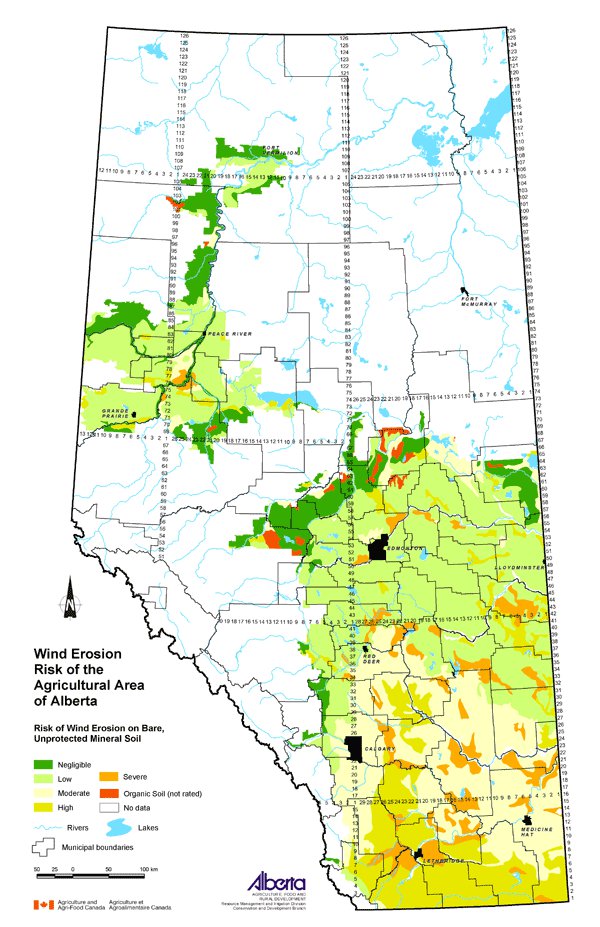
This map displays the risk of soil degradation by wind in the agricultural region of Alberta. Wind erosion is a concern because it reduces soil quality by removing soil nutrients, smaller soil particles and organic matter. Wind erosion can reduce air quality during extreme erosion events and also reduce water quality if eroded particles drift into streams and lakes.

The map uses five classes to describe the wind erosion risk on bare, unprotected mineral soil: negligible, low, moderate, high and severe.

Data Sources

This is a 1:3 000 000 scale representation of a map titled Wind Erosion Risk, Alberta by Coote and Pettapiece (1989). The original 1:1 000 000 scale map used the Soil Landscapes of Canada (SLC) polygons to display the soils information.

SLC polygons were created using existing soil survey information. Each polygon is described by a standard set of soil and land attributes that characterizes the soil landscapes found in each SLC polygon. Soils, landscapes and climate are the key natural resource factors that determine agricultural productivity, and the farms within a soil landscape unit usually have similar production characteristics.

Wind Erosion Risk, Alberta used SLC information as well as information on wind speed, soil resistance to movement and available moisture. These factors were used to estimate the long-term risk of wind erosion on bare, unprotected soils.

Potential Uses

This map illustrates that some areas of the province have a greater potential for wind erosion based on soil and land characteristics of the SLC and climatic conditions. By understanding that some areas of the province have a greater risk of wind erosion than others, beneficial management practices that reduce the effects can be directed to these areas. For example, practices that maintain a vegetative cover (e.g. perennial forages or crop residues), reduce cultivated fallow, reduce or eliminate tillage, use field shelterbelts and avoid overgrazing, could be promoted in high-risk areas.

Limitations

The map is intended for interpreting wind erosion risk in general classes useful at the regional level only.

Further Information

Alberta Agriculture and Food (AF) provides information about wind erosion control, management practices and losses from wind erosion. From the AF website, under Quick Links on the right side, follow: Publications & More, then Soils and Water Publications. www.agric.gov.ab.ca/publications

Coote, D.R. and Pettapiece, W.W. 1989. Wind Erosion Risk, Alberta. Land Resource Research Centre, Research Branch, Agriculture Canada. Publication 5255/B. Contribution Number 87-08.

Click on map for larger view


Download Spatial Information

Agricultural Land Resource Atlas of Alberta - Wind Erosion Risk of the Agricultural Area of Alberta


Other Documents in the Series

 
  Agricultural Land Resource Atlas of Alberta - Preface
Agricultural Land Resource Atlas of Alberta - Municipal Districts and Counties of Alberta
Agricultural Land Resource Atlas of Alberta - Township Grid System of Alberta
Agricultural Land Resource Atlas of Alberta - Annual Total Precipitation of Alberta, 1971 to 2000
Agricultural Land Resource Atlas of Alberta - Frost-free Period of Alberta, 1971 to 2000
Agricultural Land Resource Atlas of Alberta - Annual Solar Radiation of Alberta, 1971 to 2000
Agricultural Land Resource Atlas of Alberta - Areal Extent of Wetlands in the Agricultural Area of Alberta
Agricultural Land Resource Atlas of Alberta - Soil Groups of Alberta
Agricultural Land Resource Atlas of Alberta - Soil Texture of the Agricultural Area of Alberta
Agricultural Land Resource Atlas of Alberta - Saline Soils of the Agricultural Area of Alberta
Agricultural Land Resource Atlas of Alberta - Solonetzic Soils of the Agricultural Area of Alberta
Agricultural Land Resource Atlas of Alberta - Organic Matter Content of Cultivated Soils of the Agricultural Area of Alberta
Agricultural Land Resource Atlas of Alberta - Organic Soils of the Agricultural Area of Alberta
Agricultural Land Resource Atlas of Alberta - Water Erosion Risk of the Agricultural Area of Alberta
Agricultural Land Resource Atlas of Alberta - Wind Erosion Risk of the Agricultural Area of Alberta - Current Document
Agricultural Land Resource Atlas of Alberta - Aquifer Vulnerability Index for the Agricultural Area of Alberta
Agricultural Land Resource Atlas of Alberta - Fertilizer Expense Index for the Agricultural Area of Alberta
Agricultural Land Resource Atlas of Alberta - Chemical Expense Index for the Agricultural Area of Alberta
Agricultural Land Resource Atlas of Alberta - Manure Production Index for the Agricultural Area of Alberta
Agricultural Land Resource Atlas of Alberta - Cultivation Intensity Index for the Agricultural Area of Alberta
Agricultural Land Resource Atlas of Alberta - Number of Species at Risk in Alberta
Agricultural Land Resource Atlas of Alberta - Surface Water Quality Risk for the Agricultural Area of Alberta
Agricultural Land Resource Atlas of Alberta - Groundwater Quality Risk for the Agricultural Area of Alberta
Agricultural Land Resource Atlas of Alberta - Soil Erosion Risk for the Agricultural Area of Alberta
Agricultural Land Resource Atlas of Alberta - Air Quality Risk for the Agricultural Area of Alberta
Agricultural Land Resource Atlas of Alberta - Biodiversity Risk for the Agricultural Area of Alberta


Share via AddThis.com
For more information about the content of this document, contact David Spiess.
This document is maintained by Jennifer Rutter.
This information published to the web on September 1, 2005.
Last Reviewed/Revised on January 29, 2018.