| | Description | Data sources | Potential uses | Limitations | Further information | Download spatial information
Description
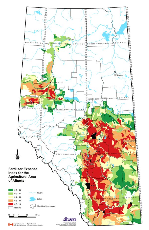
This map shows the relative expense of fertilizer and lime in the agricultural area of Alberta. It is an estimate of the degree to which agriculture may affect nutrient levels in surface and groundwater. The classes shown on the map are ranked between 0 (lowest) and 1 (highest).
Data Sources
Data on the amount spent on fertilizer and lime by producers was collected during the 2001 Census of Agriculture. Custom processing of the Census data by Statistics Canada gives the fertilizer expense ($) for each Soil Landscapes of Canada (SLC) polygon. That amount was divided by the SLC area (square km) to result in a ratio of the amount spent on fertilizer per unit area for each SLC.
SLC Version 1.9 was used for this map. SLC polygons were created using existing soil survey information. Each polygon is described by a standard set of soil and land attributes that characterizes the soil landscapes found in each SLC polygon. Soils, landscapes and climate are the key natural resource factors that determine agricultural productivity, and the farms within a soil landscape unit usually have similar production characteristics.
The values for each SLC were ranked with the lowest value assigned a new value of 0.0 and the SLC with the maximum ratio assigned a new value of 1.0. All other values were assigned a new value between 0.0 and 1.0 based on their rank order.
Potential Uses
Mapping the relative values of fertilizer expenses by SLC polygon area is useful as an indication of where more fertilizer is applied in the province and as a proxy indicator for crop production.
It also suggests the relative agricultural intensity in various parts of the province. Fertilizer use has been used as one component of an Agricultural Intensity Index (AII), developed through the Alberta Environmentally Sustainable Agriculture (AESA) Water Quality Monitoring Program. Work by Anderson, Cooke and MacAlpine (1999) and by Johnson and Kirtz (1998) developed that Index. The AII has been identified as a good indicator of agricultural impacts on surface water.
Fertilizer use is a part of that equation to determine a measure of surface water quality risk. Therefore, if an area is known to have certain risk factors that would affect surface water quality, a higher fertilizer expense index ranking in that same area may be of concern. Where risks of surface water contamination exist, environmental farm planning can help to minimize them.
Limitations
Fertilizer expense data from the 2001 Census of Agriculture is used here as a proxy for the actual amount of fertilizer that is applied. While this is a reasonable connection to make, there is no adjustment made to the data to account for fertilizer price differences across the province.
Further Information
The AESA Water Quality Monitoring Program directs the numerous water quality monitoring activities taking place across the province. From the Alberta Agriculture and Food (AF) website, use the topic bar on the left and follow: Soil/Water/Air, Water Quality and Stream Monitoring. www.agric.gov.ab.ca
2001 Census of Agriculture website expands on the use of the data collected. www.statcan.ca/english/agcensus2001
Canadian Soil Information System (CanSIS) provides soils information and data including information about SLCs. From the CanSIS website under Data, click on Soil Landscapes on the left side topic bar. http://sis.agr.gc.ca/cansis
Anderson, A., Cooke, S. and MacAlpine, N. 1999. Watershed Selection for the AESA Stream Water Quality Monitoring Program. Alberta Environmentally Sustainable Agriculture, AF.
Johnson, I. and Kirtz, J. 1998. Agricultural Intensity in Alberta, 1996 and Changes Since 1991. Alberta Environmentally Sustainable Agriculture, AF.
Click on map for larger view
Download Spatial Information
Agricultural Land Resource Atlas of Alberta - Fertilizer Expense Index for the Agricultural Area of Alberta
|
|