| | Description | Data sources | Potential uses | Limitations | Further information | Download spatial information
Description
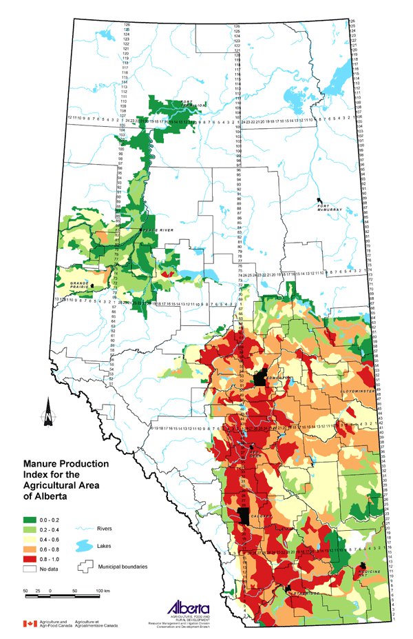
This map describes the relative amount of manure production in the agricultural area of Alberta. It is an estimate of the degree to which livestock production may contribute to nutrient loading, pathogens and odour. The classes shown on the map are ranked between 0 (lowest) and 1 (highest).
Data Sources
Data on manure production in Alberta was derived from the 2001 Census of Agriculture. Calculation and custom processing of the Census data by Statistics Canada results in manure production in tonnes for each Soil Landscapes of Canada (SLC) polygon. That amount was divided by the SLC area (square km) to result in a ratio of the manure produced per unit area for each SLC.
SLC Version 1.9 was used for this map. SLC polygons were created using existing soil survey information. Each polygon is described by a standard set of soil and land attributes that characterizes the soil landscapes found in each SLC polygon. Soils, landscapes and climate are the key natural resource factors that determine agricultural productivity, and the farms within a soil landscape unit usually have similar production characteristics.
The 2001 Census of Agriculture collected information about the numbers of all livestock raised in the province. Using research by Culley and Barnett (1984), Statistics Canada calculated the amount of manure produced by the total number of livestock. A formula that weighted the different livestock based on animal size and average manure output was used. The numbers of each type of livestock reported in the Census, multiplied by its manure factor, were totalled to give the total manure produced in tonnes.
The values for each SLC were ranked with the lowest value assigned a new value of 0.0 and the SLC with the maximum ratio assigned a new value of 1.0. All other values were assigned a new value between 0.0 and 1.0 based on their rank order.
Potential Uses
Mapping manure production gives some indication of where in the province livestock production is most concentrated. This is important to know when issues related to manure management arise. Proper manure storage, handling and application are important wherever livestock are produced but especially in areas with a higher manure production index.
Manure production has been used as one component of an Agricultural Intensity Index (AII), developed through the Alberta Environmentally Sustainable Agriculture (AESA) Water Quality Monitoring Program. Work by Anderson, Cooke and MacAlpine (1999) and by Johnson and Kirtz (1998) developed that Index. The AII has been identified as a good indicator of agricultural impacts on surface water.
Manure production is a part of that equation to determine a measure of surface water quality risk. Therefore, if an area is known to have certain risk factors that would affect not only surface water but groundwater quality as well, a higher manure production index ranking in that same area may be of concern. Where risks of surface or groundwater contamination exist, environmental farm planning can help to minimize them.
Limitations
The Census of Agriculture does not collect data about how much manure is actually produced. The calculation used is a best estimate of manure production per animal unit based on the numbers of livestock raised in the province.
Further Information
Alberta Agriculture and Food (AF) has information about manure management. From the AF website, use the topic bar on the left and follow: Soil/Water/Air, Soil Fertility and Manure. www.agric.gov.ab.ca
Canadian Soil Information System (CanSIS) provides soils information and data including information about SLCs. From the CanSIS website under Data, click on Soil Landscapes on the left side topic bar. http://sis.agr.gc.ca/cansis
2001 Census of Agriculture website expands on the use of the data collected. www.statcan.ca/english/agcensus2001
Anderson, A., Cooke, S. and MacAlpine, N. 1999. Watershed Selection for the AESA Stream Water Quality Monitoring Program. Alberta Environmentally Sustainable Agriculture, AF.
Culley, J.B. and Barnett, G.M. 1984. Land Disposal of Manure in Province of Quebec. Canadian Journal of Soil Science. 64: 75-86.
Johnson, I. and Kirtz, J. 1998. Agricultural Intensity in Alberta, 1996 and Changes Since 1991. Alberta Environmentally Sustainable Agriculture, AF.
Click on map for larger view
Download Spatial Information
Agricultural Land Resource Atlas of Alberta - Manure Production Index for the Agricultural Area of Alberta
|
|