| | Description | Data sources | Potential uses | Limitations | Further information | Download spatial information
Description
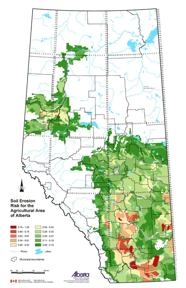
This map displays an assessment of soil erosion risk for the agricultural area of Alberta. Loss of protective residue cover through cultivation will increase the potential risk of soil erosion. The vulnerability of the soil to erosion combined with the intensity of cultivation determines the degree to which the soil may be at risk. The classes shown on the map were ranked from 0 (lowest risk) to 1 (highest risk).
Data Sources
The soil erosion risk assessment procedure integrates wind and water erosion risk with land management practices, specifically cultivation.
Information about tillage practices was collected during the 2001 Census of Agriculture. The Census questions provided an estimate of the area of no till, conservation tillage, conventional tillage and summerfallow on farms in Alberta. Custom processing of the data by Statistics Canada yielded the percent of the land within each Soil Landscapes of Canada (SLC) polygon associated with the four management systems.
SLC Version 1.9 was used for this map. SLC polygons were created using existing soil survey information. Each polygon is described by a standard set of soil and land attributes that characterizes the soil landscapes found in each SLC polygon. Soils, landscapes and climate are the key natural resource factors that determine agricultural productivity, and the farms within a soil landscape unit usually have similar production characteristics.
The cultivation rating is a measure of the cultivation intensity with management systems having a greater frequency of cultivation weighted higher. The cultivation rating was calculated for each SLC polygon by the following formula:
Cultivation rating = (% area in no till) x 1 + (% area in conservation tillage) x 2 + (% area in conventional tillage) x 3 + (% area in summerfallow) x 4
The assessment of the soil erosion risk is based, in part, upon the potential erodibility of the soil landscape by wind and water. For this assessment, the wind erosion risk (Coote and Pettapiece, 1989) and water erosion risk (Tajek and Coote, 1993) ratings were used. Risk classes were assigned integer values to describe the wind erosion risk and water erosion risk on bare, unprotected mineral soil for each SLC. The risk classes were negligible (1), low (2), moderate (3), high (4) and severe (5). The erosion risk value assigned to each SLC polygon was the average of the corresponding wind risk value and water risk value.
The cultivation rating was multiplied by the soil erosion risk value and the result ranked from 0 to 1 to form the soil erosion risk factor for each SLC as displayed on the map.
Potential Uses
This map helps to identify areas where soil may be at risk to wind or water erosion. In areas of greater soil erosion risk, promotion of beneficial management practices such as reduced tillage, direct seeding, field shelterbelts, reduce or eliminate summerfallow, increase crop residue cover or avoid overgrazing can be encouraged.
Limitations
A soil erosion risk rating at the SLC polygon level of representation makes the data useful at the regional level only.
Further Information
Alberta Agriculture and Food (AF) provides information about wind and water erosion including control and management practices. From the AF website, under Quick Links on the right side follow: Publications & More, then Soils, Water, Reclamation Publications under Free Publications. www.agric.gov.ab.ca/publications
2001 Census of Agriculture website expands on the use of the data collected. www.statcan.ca/english/agcensus2001
Reduced Tillage LINKAGES (RTL) is a partnership with broad-based support to develop an extension program focused on improving the environmental and economic sustainability of farming in Alberta. www.reducedtillage.ca
Canadian Soil Information System (CanSIS) provides soils information and data including information about SLCs. From the CanSIS website under Data, click on Soil Landscapes on the left side topic bar. http://sis.agr.gc.ca/cansis
Coote, D.R. and Pettapiece, W.W. 1989. Wind Erosion Risk, Alberta. Land Resource Research Centre, Research Branch, Agriculture Canada. Publication 5255/B. Contribution Number 87-08.
Tajek, J. and Coote, D.R. 1993. Water Erosion Risk, Alberta. Land Resource Research Centre, Research Branch, Agriculture Canada. Publication 5292/B. Contribution Number 92-05.
Click on map for larger view
Download Spatial Information
Agricultural Land Resource Atlas of Alberta - Soil Erosion Risk for the Agricultural Area of Alberta
|
|