| | Description | Data sources | Potential uses | Limitations | Further information | Download spatial information
Description
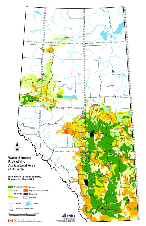
This map displays the risk of soil degradation by water in the agricultural region of Alberta. Water erosion is a concern because it reduces soil quality by removing soil particles and nutrients, and reduces water quality if these particles are carried into nearby water bodies.
The map uses five classes to describe the water erosion risk on bare, unprotected mineral soil: negligible, low, moderate, high and severe.
Data Sources
This is a 1:3 000 000 scale representation of a map titled Water Erosion Risk, Alberta by Tajek and Coote (1993). The original 1:1 000 000 scale map used the Soil Landscapes of Canada (SLC) polygons to display the soils information.
SLC polygons were created using existing soil survey information. Each polygon is described by a standard set of soil and land attributes that characterizes the soil landscapes found in each SLC polygon. Soils, landscapes and climate are the key natural resource factors that determine agricultural productivity, and the farms within a soil landscape unit usually have similar production characteristics.
Water Erosion Risk, Alberta used SLC information and the Universal Soil Loss Equation (USLE) to estimate the risk of water erosion on bare, unprotected mineral soils. USLE analyses are useful for comparing the erosion risk between polygons rather than focusing on the actual value of soil loss. The USLE combines soils data and factors that affect water erosion including erosivity of rainfall and snowmelt, soil erodibility, slope length and steepness. Crop cover and conservation practice are parameters that can be incorporated into the USLE, but in this case, these factors were not included since erosion risk ratings for bare, unprotected soil were desired.
Potential Uses
This map illustrates that some areas of the province have a greater potential for water erosion based on soil and land characteristics of the SLC and climatic conditions. By understanding that some areas of the province have a greater risk of water erosion than others, beneficial management practices that reduce the effects can be directed to these areas. For example, practices that increase crop residue cover and decrease the amount of tillage could be promoted in high-risk areas.
Limitations
The map is intended for interpreting water erosion risk in general classes useful at the regional level only.
Further Information
Alberta Agriculture and Food (AF) has information about water erosion, its control and prediction as well as management practices that can be used for its prevention. From the AF website, under Quick Links on the right side, follow: Publications & More, then Soils and Water Publications. www.agric.gov.ab.ca/publications
Tajek, J. and Coote, D.R. 1993. Water Erosion Risk, Alberta. Land Resource Research Centre, Research Branch, Agriculture Canada. Publication 5292/B. Contribution Number 92-05.
Click on map for larger view
Download Spatial Information
Agricultural Land Resource Atlas of Alberta - Water Erosion Risk of the Agricultural Area of Alberta
|
|