| | Description | Data sources | Potential uses | Further information | Download spatial information
Description
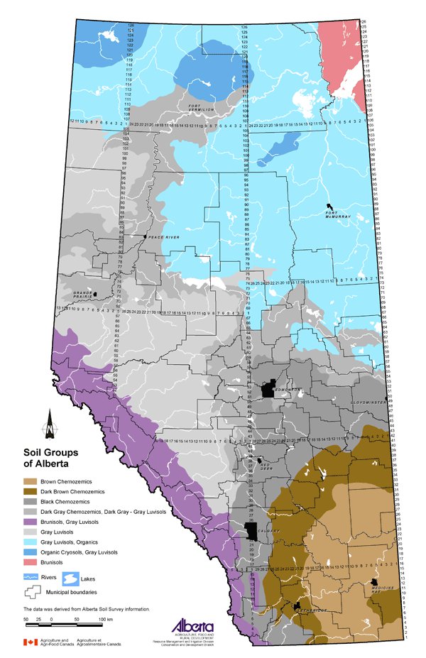
This map displays the distribution of the main soil types found within the province. The distribution pattern of soils in Alberta is strongly linked to climate and parent materials. Climate affects the location of different soil groups. The driest area in southeastern Alberta is represented by the presence of Brown Chernozems. As one proceeds north and west, the soils and associated vegetation reflect the increase in available moisture.
Chernozemic soils are primarily associated with grassland vegetation. Brown Chernozemic soils occur in the southeast part of the province and are characterized by the presence of a brown surface layer approximately 10 to 12 cm thick that generally contains 3 to 4 percent organic matter. Available moisture is the limiting factor to crop growth with most of the area in native range. With increasing available moisture, there is a transition to Dark Brown Chernozemic soils. These soils are characterized by the presence of a dark brown soil surface layer that is 12 to 15 cm thick that generally contains 4 to 6 percent organic matter. Moisture continues to be a limiting factor to crop production; however, the majority of the area is cultivated. Black Chernozemic soils are associated with grassland areas with the most available moisture and cooler temperatures. These soils are characterized by the presence of a black surface horizon that is 12 to 20 cm thick with organic matter generally in the range of 6 to 10 percent. These are highly productive soils that are used to grow a wide variety of agricultural crops. Dark Gray Chernozemic soils are associated with the transition between grassland and forest vegetation. These soils are similar to Black Chernozems with respect to surface layer thickness and organic matter content; however, the average frost-free period is a more limiting factor for annual agricultural crops.
Luvisolic soils are associated with mixed forest vegetation under native conditions. This vegetative cover reflects an increase in available moisture in conjunction with cooler temperatures. Under native conditions, there is a layer of decomposing litter on the surface of the mineral soil. Upon removal of the forest vegetation for agricultural activities, the organic matter is incorporated into the mineral soil resulting in a dark gray surface colour. The organic matter content of this surface layer generally increases under long-term agricultural activities.
Brunisolic soils within Alberta are generally associated with well-drained landscapes. In Alberta, they occur in high elevation montane, sub-alpine and alpine areas as well as on the Canadian Shield. These soils are characterized by having a thin (2 to 15 cm thick) dark brown to black surface layer of variable organic matter content. Climatic limitations, primarily the frost-free period, limit agricultural activities.
Cryosolic soils have permafrost within one meter of the surface. In Alberta, these soils are associated with the upper reaches of the Caribou Mountains and Cameron Hills. Agricultural activities are not feasible in these areas.
In Alberta, Organic soils generally occur in association with Luvisolic soils. These soils form under wet conditions where the organic layer (greater than 30% organic matter) accumulates faster than it decomposes. The organic layer varies in thickness from 40 to 160+ cm, and under natural conditions, the water table is at or near the surface. In some areas of the province, Organic soils may be artificially drained and used for agricultural production.
Data Sources
The soil group polygons shown on the map represent Alberta Soil Survey information. The information represented by this map is consistent with The Canadian System of Soil Classification, which is the basis for describing soils across the country that was compiled by the Alberta Land Resource Unit, Research Branch of Agriculture and Agri-Food Canada, in 1995.
Potential Uses
Soils have been classified and grouped based on their similar properties and the factors that contributed to their formation. Familiarity with the soil group of a particular area provides a broad scale overview of the general landscape characteristics, management options and limitations as related to agricultural production potential.
Limitations
The soil groups are broad groupings of the dominant soil types of an area. Within any one area, many other soil types are present. At this map scale, only the most prevalent soil type(s) is described. Boundaries between soil groups are transitional in nature.
Further Information
Alberta Soil Information Centre provides digital files and published maps and reports for users of soils information. The Soil Groups of Alberta map is also available here with links to further soil descriptions as well as landscape and profile photographs. www.agric.gov.ab.ca/asic
Canadian Soil Information System (CanSIS) provides soils information and maps for all of Canada. Publications including The Canadian System of Soil Classification are available from the website. http://sis.agr.gc.ca/cansis
Click on map for larger view
Download Spatial Information
Agricultural Land Resource Atlas of Alberta - Soil Groups of Alberta
|
|