Agricultural Land Resource Atlas of Alberta - Municipal Districts and Counties of Alberta


Download 230K pdf file ("pg_2_muncipal_disricts.pdf")PDF
(230K)
     Subscribe to our free E-Newsletter, "Agri-News" (formerly RTW This Week)Agri-News
This Week


 Description | Data sources | Potential uses | Limitations | Further information

Description

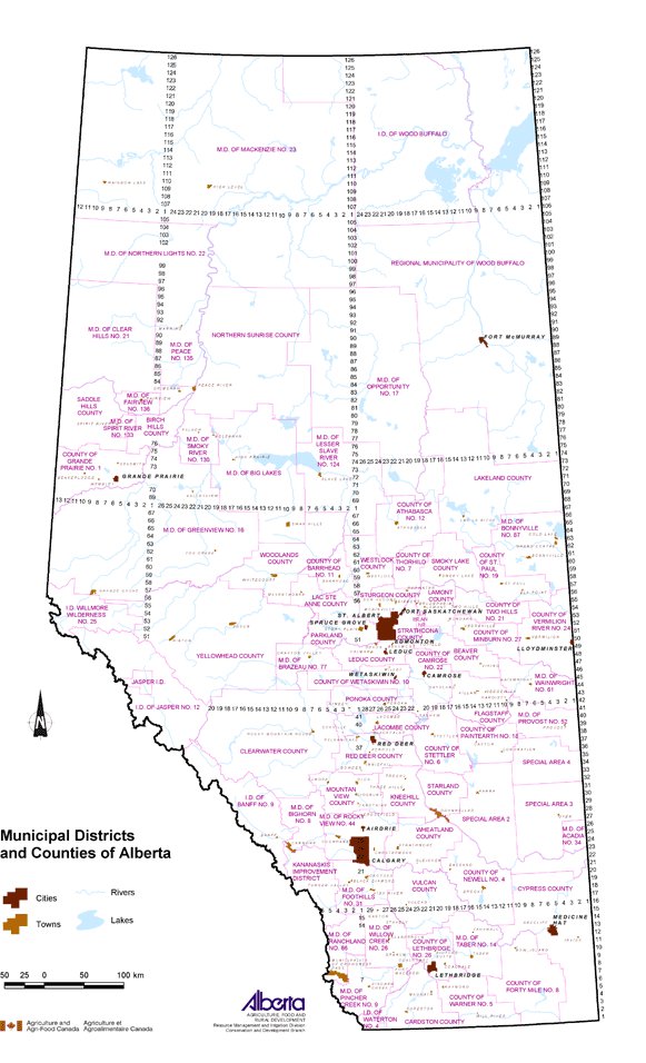
Municipal Districts and Counties of Alberta shows the location of the rural, urban and specialized municipalities in Alberta as of 2003.

Data Sources

The Municipal Boundary File containing the digital map information was obtained from AltaLIS Ltd. This file contains provincial coverage of municipal boundary linework, featuring rural municipalities, cities, towns, villages, summer villages and hamlets at an accuracy of ± 3 metres. Only the cities and main towns were displayed in the final map along with the main rivers and lakes.

Potential Uses

This map is useful to identify municipality location and where a municipality is located in relation to neighboring municipalities. Once the municipal jurisdiction is verified, accessibility to area-specific programs can be determined.

Limitations

The names and boundaries of municipalities may change from year to year. Up-to-date information can be obtained by contacting Alberta Municipal Affairs (website below).

Further Information

Additional information about individual municipalities can be obtained from the municipalities themselves.

The Alberta Municipal Affairs website contains numerous types of information including:

  • Information about the types of municipalities in Alberta. From the homepage, click on For Albertans along the top, then About Municipalities under Resources. Or, toll free call 310-0000, then dial (780) 427-8862.
  • Rural Municipal Boundary Map is available online and connects to basic municipality profile information such as location description, list of urban municipalities and hamlets within the municipal boundary and incorporation history. From the homepage, click on For Albertans along the top, then Municipal Boundary Map under Resources.
  • Communities within Specialized and Rural Municipalities, published in January 2004, lists all of the communities in Alberta and the municipality in which they are located. From the homepage, click on For Albertans along the top, then Communities within Rural Municipal Boundaries under Resources. www.municipalaffairs.gov.ab.ca
Maps of individual municipalities are available from Map Town. www. maptown.com
Municipal maps are also available at www.mapstore.ca

AltaLIS Ltd. is the joint venture company that maintains and distributes Alberta's base mapping data sets. www.altalis.com

Click on map for larger view


Other Documents in the Series

 
  Agricultural Land Resource Atlas of Alberta - Preface
Agricultural Land Resource Atlas of Alberta - Municipal Districts and Counties of Alberta - Current Document
Agricultural Land Resource Atlas of Alberta - Township Grid System of Alberta
Agricultural Land Resource Atlas of Alberta - Annual Total Precipitation of Alberta, 1971 to 2000
Agricultural Land Resource Atlas of Alberta - Frost-free Period of Alberta, 1971 to 2000
Agricultural Land Resource Atlas of Alberta - Annual Solar Radiation of Alberta, 1971 to 2000
Agricultural Land Resource Atlas of Alberta - Areal Extent of Wetlands in the Agricultural Area of Alberta
Agricultural Land Resource Atlas of Alberta - Soil Groups of Alberta
Agricultural Land Resource Atlas of Alberta - Soil Texture of the Agricultural Area of Alberta
Agricultural Land Resource Atlas of Alberta - Saline Soils of the Agricultural Area of Alberta
Agricultural Land Resource Atlas of Alberta - Solonetzic Soils of the Agricultural Area of Alberta
Agricultural Land Resource Atlas of Alberta - Organic Matter Content of Cultivated Soils of the Agricultural Area of Alberta
Agricultural Land Resource Atlas of Alberta - Organic Soils of the Agricultural Area of Alberta
Agricultural Land Resource Atlas of Alberta - Water Erosion Risk of the Agricultural Area of Alberta
Agricultural Land Resource Atlas of Alberta - Wind Erosion Risk of the Agricultural Area of Alberta
Agricultural Land Resource Atlas of Alberta - Aquifer Vulnerability Index for the Agricultural Area of Alberta
Agricultural Land Resource Atlas of Alberta - Fertilizer Expense Index for the Agricultural Area of Alberta
Agricultural Land Resource Atlas of Alberta - Chemical Expense Index for the Agricultural Area of Alberta
Agricultural Land Resource Atlas of Alberta - Manure Production Index for the Agricultural Area of Alberta
Agricultural Land Resource Atlas of Alberta - Cultivation Intensity Index for the Agricultural Area of Alberta
Agricultural Land Resource Atlas of Alberta - Number of Species at Risk in Alberta
Agricultural Land Resource Atlas of Alberta - Surface Water Quality Risk for the Agricultural Area of Alberta
Agricultural Land Resource Atlas of Alberta - Groundwater Quality Risk for the Agricultural Area of Alberta
Agricultural Land Resource Atlas of Alberta - Soil Erosion Risk for the Agricultural Area of Alberta
Agricultural Land Resource Atlas of Alberta - Air Quality Risk for the Agricultural Area of Alberta
Agricultural Land Resource Atlas of Alberta - Biodiversity Risk for the Agricultural Area of Alberta


Share via AddThis.com
For more information about the content of this document, contact David Spiess.
This document is maintained by Jennifer Rutter.
This information published to the web on September 1, 2005.
Last Reviewed/Revised on January 31, 2018.