| | Description | Data sources | Potential uses | Limitations | Further information | Download spatial information
Description
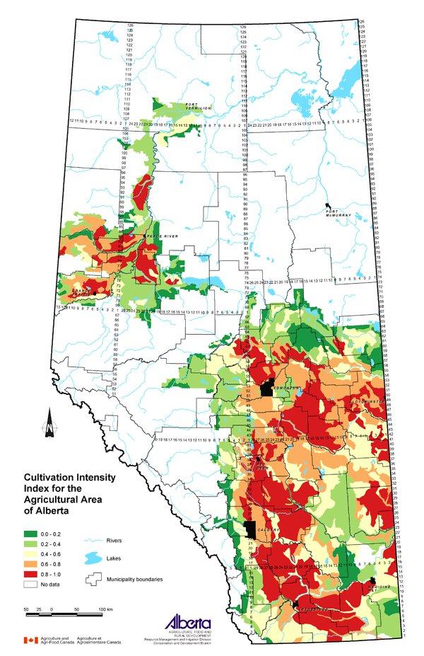
This map presents the relative cultivation intensity in the agricultural area of Alberta. Cultivation intensity refers to the frequency of cultivation associated with the following management systems: no till, conservation tillage, conventional tillage and summerfallow. It is an estimate of the degree to which cultivation contributes to wind and water erosion. The classes shown on the map are ranked between 0 (lowest) and 1 (highest).
Data Sources
Data used to determine the cultivation rating was collected during the 2001 Census of Agriculture. Census questions provided an estimate of the area of no till, conservation tillage, conventional tillage and summerfallow on farms in Alberta. Custom processing of the data by Statistics Canada yielded the percent of the land within each Soil Landscapes of Canada (SLC) polygon associated with the four management systems.
SLC Version 1.9 was used for this map. SLC polygons were created using existing soil survey information. Each polygon is described by a standard set of soil and land attributes that characterizes the soil landscapes found in each SLC polygon. Soils, landscapes and climate are the key natural resource factors that determine agricultural productivity, and the farms within a soil landscape unit usually have similar production characteristics.
The cultivation rating is a measure of the cultivation intensity, with management systems having a greater frequency of cultivation weighted higher. The cultivation rating was calculated for each SLC by the following formula:
Cultivation rating = (% area in no till) x 1 + (% area in conservation tillage) x 2 + (% area in conventional tillage) x 3 + (% area in summerfallow) x 4
The cultivation rating for each SLC was converted to an index value between 0.0 and 1.0, where 0.0 referred to uncultivated land and 1.0 had the highest value of cultivation intensity.
Potential Uses
The agricultural activity with the most impact on soil quality in Alberta is cultivation. This impact is represented quantitatively through a cultivation rating based on frequency of cultivation called the cultivation intensity.
In general, more cultivation means a greater risk of wind and water erosion. However, the physical characteristics of the soil and landscape will have an influence on the sensitivity of the soils to cultivation. Mapping this information identifies areas with a high cultivation intensity index, which then can be assessed for soil characteristics that may make them susceptible to erosion. In these areas, promotion of beneficial management practices such as reduced tillage, direct seeding and reducing or eliminating summerfallow can be encouraged.
Limitations
One rating is given for each SLC, which makes the data useful at a regional level only.
Further Information
2001 Census of Agriculture website expands on the use of the data collected. www.statcan.ca/english/agcensus2001
Reduced Tillage LINKAGES (RTL) is a partnership with broad-based support to develop an extension program focused on improving the environmental and economic sustainability of farming in Alberta. www.reducedtillage.ca
Canadian Soil Information System (CanSIS) provides soils information and data including information about SLCs. From the CanSIS website under Data, click on Soil Landscapes on the left side topic bar. http://sis.agr.gc.ca/cansis
Click on map for larger view
Download Spatial Information
Agricultural Land Resource Atlas of Alberta - Cultivation Intensity Index for the Agricultural Area of Alberta
|
|