| | Description | Data sources | Potential uses | Limitations | Further information | Download spatial information
Description
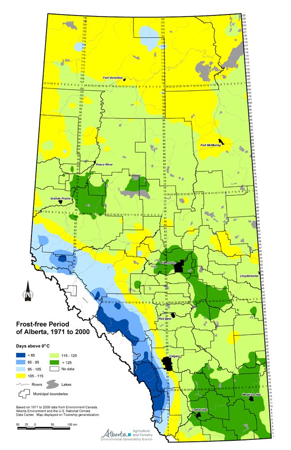
This map illustrates the frost-free period in Alberta for the 30 years from 1971 to 2000. A 30-year period is used to describe the present climate since it is enough time to filter out short-term fluctuations but is not dominated by any long-term trend in the climate.
The frost-free period is the number of days between the last date of 0�C in the spring and the first date of 0�C in the fall. Frost-free periods in Alberta vary from more than 125 days in the south to less than 85 days in higher elevation, non-agricultural areas.
The frost-free period is presented as days above 0�C in the following classes: less than 85, 85 to 95, 95 to 105, 105 to 115, 115 to 125 and greater than 125.
Data Sources
Frost-free Period of Alberta, 1971 to 2000, is found in the Agroclimatic Atlas of Alberta, 1971 to 2000 (Chetner and the Agroclimatic Atlas Working Group, 2003). This map was based on 1971 to 2000 data from Environment Canada, Alberta Environment and the United States National Climate Data Center. These agencies collect data from over 1200 climate stations in Alberta and 1400 stations in neighboring provinces, territories and states. The stations collect daily temperature and precipitation information. Environment Canada receives the majority of the data from the federal and provincial networks and performs quality control on the data. Data from the United States stations is provided by the U.S. National Climate Data Center.
The temperature data collected was used to derive frost dates and, in turn, the frost-free period. Temperature data collected at climate stations was interpolated between stations and rolled up to a township. In order to avoid the blocky appearance of townships on the map, a township generalization was produced using smoothing procedures of computer graphics software for final presentation on the map.
Potential Uses
The frost-free period provides a measure of the period during which plant growth should occur uninterrupted by frost, and it provides a way to compare growing conditions within the province. When selecting new crop types and varieties, producers consider climate characteristics including the length of the frost-free period and the expected date of fall frost. It is important information for producers for planning purposes, indicating where the advantages of growing a particular crop may outweigh the risk of occasional frost damage. The yield potential of some crops is closely related to the growing season length. Generally, for the production of marketable grain crops, the frost-free period needs to be greater than 100 days.
Limitations
A frost-free period of the same value in different areas of the province where the day length varies can have different meanings. For example, the longer day length in the Peace River Region partly compensates for the effects of the shorter frost-free period in the north, when compared to the shorter day length and longer frost-free period in southern Alberta. Each crop reacts differently to increasing day length, so no general adjustment of frost-free periods for day length is possible.
Further Information
The Agroclimatic Atlas of Alberta, 1971 to 2000, is available online at the Alberta Agriculture and Food (AF) website by using the topic bar at the left and following Weather & Climate and then Agroclimatic Atlas.
Chetner, S. and the Agroclimatic Atlas Working Group. 2003. Agroclimatic Atlas of Alberta, 1971 to 2000. AF. Agdex 071-1. Edmonton, Alberta.
Download Spatial Information
Click on map for larger view
Agricultural Land Resource Atlas of Alberta - Frost-free Period of Alberta, 1971 to 2000
The Map and links below have been superseded by the Map and links above:
|
|