| | Description | Data sources | Potential uses | Limitations | Further information | Download spatial information
Description
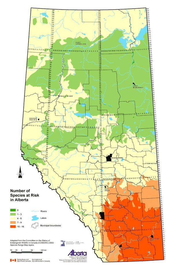
This map describes the number of animal and plant species that are at risk in Alberta. "Species at risk" is a term used by the Committee on the Status of Endangered Wildlife in Canada (COSEWIC) that includes the following categories of plants and animals:
 Extirpated species - no longer in the wild in Canada. Extirpated species - no longer in the wild in Canada.
 Endangered species - species facing imminent extirpation or extinction. Endangered species - species facing imminent extirpation or extinction.
 Threatened species - likely to become an endangered species if nothing is done to reverse factors leading to its extirpation or extinction. Threatened species - likely to become an endangered species if nothing is done to reverse factors leading to its extirpation or extinction.
 Species of special concern - species that may become threatened or endangered due to biological characteristics or identified threats. Species of special concern - species that may become threatened or endangered due to biological characteristics or identified threats.
The number of species at risk are displayed on the map using the following classes: 0, 1 to 3, 4 to 6, 7 to 9, and 10 to 16. The species at risk in Alberta in 2002 were:
 American badger (jeffersonii subspecies) American badger (jeffersonii subspecies) |  Sage thrasher Sage thrasher |
 Anatum peregrine falcon Anatum peregrine falcon |  Short-eared owl Short-eared owl |
 Burrowing owl Burrowing owl |  Slender mouse-ear-cress Slender mouse-ear-cress |
 Deepwater sculpin (Great Lakes populations) Deepwater sculpin (Great Lakes populations) |  Small-flowered sand-verbena Small-flowered sand-verbena |
 Eastern short-horned lizard Eastern short-horned lizard |  Smooth goosefoot Smooth goosefoot |
 Ferruginous hawk Ferruginous hawk |  Soapweed Soapweed |
 Great plains toad Great plains toad |  Spragues pipit Spragues pipit |
 Grizzly bear Grizzly bear |  Swift fox Swift fox |
 Hare-footed locoweed Hare-footed locoweed |  Tiny cryptanthe Tiny cryptanthe |
 Long-billed curlew Long-billed curlew |  Weidemeyer's admiral Weidemeyer's admiral |
 Monarch butterfly Monarch butterfly |  Western blue-flag Western blue-flag |
 Mountain plover Mountain plover |  Western silvery minnow Western silvery minnow |
 Northern leopard frog (Prairie population) Northern leopard frog (Prairie population) |  Western spiderwort Western spiderwort |
 Ords kangaroo rat Ords kangaroo rat |  Wolverine (Western population) Wolverine (Western population) |
 Piping plover (circumcinctus subspecies) Piping plover (circumcinctus subspecies) |  Wood bison Wood bison |
 Prairie loggerhead shrike Prairie loggerhead shrike |  Woodland caribou (Boreal population) Woodland caribou (Boreal population) |
 Sage grouse (Prairie population) Sage grouse (Prairie population) |  Yellow rail Yellow rail |
Data Sources
COSEWIC is a committee of experts that assesses and designates which wild species are in some danger of disappearing from Canada. Individual COSEWIC 2002 Species Range Maps were downloaded from the COSEWIC website. These maps show the natural habitat area of each of the species at risk. The number of these areas that overlapped at any given location in the landscape was used to designate the number of species at risk at that location.
Potential Uses
This map is useful for increasing awareness of biological diversity (biodiversity) concerns in the province. Maintaining biodiversity is essential for ensuring a healthy environment. The more diverse the ecosystem, the better it is able to respond to environmental changes or stresses, such as floods, drought, pests and disease.
Knowing where more species are at risk creates awareness of how human activities may be affecting biodiversity. Greater biodiversity in agricultural landscapes provides more land management choices and increases the stability of an ecosystem.
Limitations
This map should be used as a broad indication of the number of species at risk and distribution of those numbers in the province. By using the number of natural habitat areas of the species at risk that overlap as a surrogate for actual density of species at risk, the map is showing the range of the species that overlap and should be used at a regional level only.
Further Information
COSEWIC www.cosewic.gc.ca
Alberta Environmentally Sustainable Agriculture program provides information about agricultural biodiversity. From the Alberta Agriculture and Food website, use the topic bar on the left and follow: Soil/Water/Air, Environmental Stewardship and Biodiversity. www.agric.gov.ab.ca.
Click on map for larger view
Download Spatial Information
Agricultural Land Resource Atlas of Alberta - Number of Species at Risk in Alberta
|
|