Agricultural Land Resource Atlas of Alberta - Organic Soils of the Agricultural Area of Alberta


Download 245K pdf file ("pg_24_organic_soils.pdf")PDF
(245K)
     Subscribe to our free E-Newsletter, "Agri-News" (formerly RTW This Week)Agri-News
This Week


 Description | Data sources | Potential uses | Limitations | Further information | Download spatial information

Description

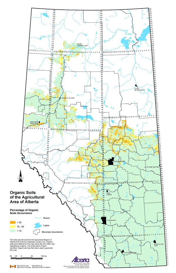
This map displays the distribution of organic soils in the agricultural region of Alberta. Organic soils consist of layers of material with greater than 30 percent organic matter and a total thickness of greater than 40 cm.

Organic soils are generally saturated with water for most of the year unless drained. Saturation inhibits decomposition and encourages continued accumulation of organic material. Drainage of these soils can result in a rapid increase in decomposition and a reduction in the thickness of the organic material.

The Agricultural Region of Alberta Soil Inventory Database (AGRASID) soil landscape polygons that contained soils belonging to the Organic Order were identified, and the areal extent of these soils was represented as a percentage of the total area using the following classes: greater than 30, 10 to 30 and less than 10.

Data Sources

The data for this map was derived from AGRASID 3.0. AGRASID is a digital database describing the spatial distribution of soils and associated landscapes within the agricultural region of Alberta.

Potential Uses

This map shows where organic soils occur, which is important since special management may be required on these soils. Organic soils may be used for extraction of peat moss, but drainage is necessary first.

Agricultural production is limited on organic soils. They are usually deficient in phosphorous, potassium and many micronutrients. Where cereal crops are grown on organic soils, copper deficiency is commonly seen in the crop. Additions of copper sulfate to the soil can correct this deficiency. Specific soil management techniques such as drainage, using forages in rotation or establishing permanent cover will enhance agricultural production on these soils.

Limitations

The map shows the areal extent of Organic Order soils. Further investigation of the soil landscape polygons is required to assess the nature of the soils present and the level of their limitations for agricultural production.

Further Information

Canadian Soil Information System (CanSIS) provides soils information and maps for all of Canada. Publications including The Canadian System of Soil Classification are available from the website. http://sis.agr.gc.ca/cansis

AGRASID provides extensive soil information and is available to download from the Alberta Soil Information Centre at the Alberta Agriculture and Food website. www.agric.gov.ab.ca/asic

Click on map for larger view


Download Spatial Information

Agricultural Land Resource Atlas of Alberta - Organic Soils of the Agricultural Area of Alberta


Other Documents in the Series

 
  Agricultural Land Resource Atlas of Alberta - Preface
Agricultural Land Resource Atlas of Alberta - Municipal Districts and Counties of Alberta
Agricultural Land Resource Atlas of Alberta - Township Grid System of Alberta
Agricultural Land Resource Atlas of Alberta - Annual Total Precipitation of Alberta, 1971 to 2000
Agricultural Land Resource Atlas of Alberta - Frost-free Period of Alberta, 1971 to 2000
Agricultural Land Resource Atlas of Alberta - Annual Solar Radiation of Alberta, 1971 to 2000
Agricultural Land Resource Atlas of Alberta - Areal Extent of Wetlands in the Agricultural Area of Alberta
Agricultural Land Resource Atlas of Alberta - Soil Groups of Alberta
Agricultural Land Resource Atlas of Alberta - Soil Texture of the Agricultural Area of Alberta
Agricultural Land Resource Atlas of Alberta - Saline Soils of the Agricultural Area of Alberta
Agricultural Land Resource Atlas of Alberta - Solonetzic Soils of the Agricultural Area of Alberta
Agricultural Land Resource Atlas of Alberta - Organic Matter Content of Cultivated Soils of the Agricultural Area of Alberta
Agricultural Land Resource Atlas of Alberta - Organic Soils of the Agricultural Area of Alberta - Current Document
Agricultural Land Resource Atlas of Alberta - Water Erosion Risk of the Agricultural Area of Alberta
Agricultural Land Resource Atlas of Alberta - Wind Erosion Risk of the Agricultural Area of Alberta
Agricultural Land Resource Atlas of Alberta - Aquifer Vulnerability Index for the Agricultural Area of Alberta
Agricultural Land Resource Atlas of Alberta - Fertilizer Expense Index for the Agricultural Area of Alberta
Agricultural Land Resource Atlas of Alberta - Chemical Expense Index for the Agricultural Area of Alberta
Agricultural Land Resource Atlas of Alberta - Manure Production Index for the Agricultural Area of Alberta
Agricultural Land Resource Atlas of Alberta - Cultivation Intensity Index for the Agricultural Area of Alberta
Agricultural Land Resource Atlas of Alberta - Number of Species at Risk in Alberta
Agricultural Land Resource Atlas of Alberta - Surface Water Quality Risk for the Agricultural Area of Alberta
Agricultural Land Resource Atlas of Alberta - Groundwater Quality Risk for the Agricultural Area of Alberta
Agricultural Land Resource Atlas of Alberta - Soil Erosion Risk for the Agricultural Area of Alberta
Agricultural Land Resource Atlas of Alberta - Air Quality Risk for the Agricultural Area of Alberta
Agricultural Land Resource Atlas of Alberta - Biodiversity Risk for the Agricultural Area of Alberta


Share via AddThis.com
For more information about the content of this document, contact David Spiess.
This document is maintained by Jennifer Rutter.
This information published to the web on September 1, 2005.
Last Reviewed/Revised on January 29, 2018.