| |
Agricultural Land Resource Atlas of Alberta - Soil Texture of the Agricultural Area of Alberta | |
| |
|
|
| |
|
|
| | Description | Data sources | Potential uses | Limitations | Further information | Download spatial information
Description
This map illustrates the distribution of soil parent material textures in the agricultural region of Alberta. Soil texture is defined by the relative proportions of the sand, silt and clay particles present. Soil textures are identified by classes using the Soil Texture Triangle illustrated below. The Soil Texture Triangle identifies the textural class of a soil at the intersection of the percent sand (x-axis) and the percent clay (y-axis). The percent silt of the soil is the remainder to add up to 100 percent.
Textural class groupings
Textural Group
| Fine | 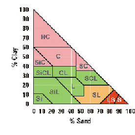 |
| HC | - Heavy Clay |
| SiC | - Silty Clay |
| C | - Clay |
| SC | - Sandy Clay |
| . |  |
| Medium |
| SiCL | - Silty Clay Loam |
| CL | - Clay Loam |
| SCL | - Sandy Clay Loam |
| Si | - Silt |
| SiL | - Silt Loam |
| L | - Loam |
| Moderately Coarse | Example Textural Class - Clay Loam CL |
| SL | - Sandy Loam | % Clay | - 28 to 40 |
| | % Sand | - 20 to 45 |
| . | | % Silt | - 15 to 52 |
| . | | | |
| Very Coarse | | |
| LS | - Loamy Sand | | |
| S | - Sand | | |
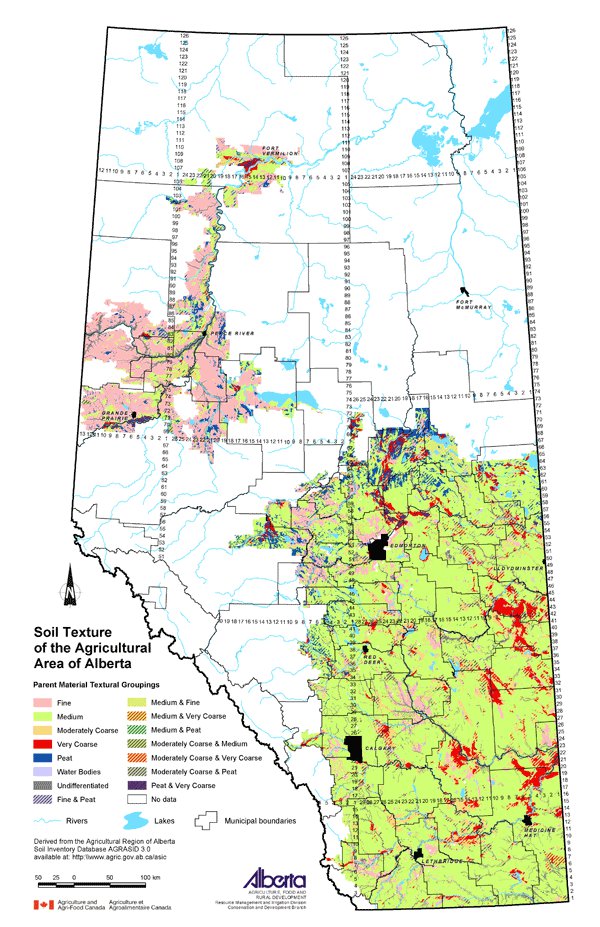
For presentation on this map, the texture classes of soil parent materials identified with each Agricultural Region of Alberta Soil Inventory Database (AGRASID) soil landscape polygon were combined into four more general groups - fine, medium, moderately coarse and very coarse. These are represented on the map by solid colors when the areal extent of the texture group occupies more than or equal to 60 percent of the soil area. Textural groupings with patterned symbols are complex areas where texture groups occupy more than or equal to 30 percent, but less than 60 percent of the area.
Other groupings identified in the map legend are Peat, Undifferentiated and Water Bodies. Peat soils have greater than 30 percent organic matter and are greater than 40 cm thick. Undifferentiated soils refer to soils where the textural group is unknown. Water Bodies refers to permanent bodies of water.
Data Sources
AGRASID 3.0 was used to produce this map. AGRASID is a digital database describing the spatial distribution of soils and associated landscapes within the agricultural region of Alberta.
Potential Uses
Soil texture will influence the water holding capacity of the soil and is useful information when considering the potential for wind and water erosion. Soil texture along with other factors including topography, climate, vegetative cover and agricultural practices will influence the degree of soil degradation that may occur in a particular area. For example, water erosion potential is generally higher for unconsolidated clays and silts than for sands and gravels.
Limitations
Soil texture will vary within each soil landscape polygon.
Further Information
AGRASID provides extensive soil information and is available to download from the Alberta Soil Information Centre at the Alberta Agriculture and Food website. www.agric.gov.ab.ca/asic
Click on map for larger view
Download Spatial Information
Agricultural Land Resource Atlas of Alberta - Soil Texture of the Agricultural Area of Alberta
|
|
| |
|
|
| |
Other Documents in the Series |
|
| |
Agricultural Land Resource Atlas of Alberta - Preface
Agricultural Land Resource Atlas of Alberta - Municipal Districts and Counties of Alberta
Agricultural Land Resource Atlas of Alberta - Township Grid System of Alberta
Agricultural Land Resource Atlas of Alberta - Annual Total Precipitation of Alberta, 1971 to 2000
Agricultural Land Resource Atlas of Alberta - Frost-free Period of Alberta, 1971 to 2000
Agricultural Land Resource Atlas of Alberta - Annual Solar Radiation of Alberta, 1971 to 2000
Agricultural Land Resource Atlas of Alberta - Areal Extent of Wetlands in the Agricultural Area of Alberta
Agricultural Land Resource Atlas of Alberta - Soil Groups of Alberta
Agricultural Land Resource Atlas of Alberta - Soil Texture of the Agricultural Area of Alberta - Current Document
Agricultural Land Resource Atlas of Alberta - Saline Soils of the Agricultural Area of Alberta
Agricultural Land Resource Atlas of Alberta - Solonetzic Soils of the Agricultural Area of Alberta
Agricultural Land Resource Atlas of Alberta - Organic Matter Content of Cultivated Soils of the Agricultural Area of Alberta
Agricultural Land Resource Atlas of Alberta - Organic Soils of the Agricultural Area of Alberta
Agricultural Land Resource Atlas of Alberta - Water Erosion Risk of the Agricultural Area of Alberta
Agricultural Land Resource Atlas of Alberta - Wind Erosion Risk of the Agricultural Area of Alberta
Agricultural Land Resource Atlas of Alberta - Aquifer Vulnerability Index for the Agricultural Area of Alberta
Agricultural Land Resource Atlas of Alberta - Fertilizer Expense Index for the Agricultural Area of Alberta
Agricultural Land Resource Atlas of Alberta - Chemical Expense Index for the Agricultural Area of Alberta
Agricultural Land Resource Atlas of Alberta - Manure Production Index for the Agricultural Area of Alberta
Agricultural Land Resource Atlas of Alberta - Cultivation Intensity Index for the Agricultural Area of Alberta
Agricultural Land Resource Atlas of Alberta - Number of Species at Risk in Alberta
Agricultural Land Resource Atlas of Alberta - Surface Water Quality Risk for the Agricultural Area of Alberta
Agricultural Land Resource Atlas of Alberta - Groundwater Quality Risk for the Agricultural Area of Alberta
Agricultural Land Resource Atlas of Alberta - Soil Erosion Risk for the Agricultural Area of Alberta
Agricultural Land Resource Atlas of Alberta - Air Quality Risk for the Agricultural Area of Alberta
Agricultural Land Resource Atlas of Alberta - Biodiversity Risk for the Agricultural Area of Alberta
|
|
| |
|
|
| |
For more information about the content of this document, contact David Spiess.
This document is maintained by Jennifer Rutter.
This information published to the web on September 1, 2005.
Last Reviewed/Revised on January 29, 2018.
|
|