Agricultural Land Resource Atlas of Alberta - Township Grid System of Alberta


Download 271K pdf file ("pg_4_township_grid.pdf")PDF
(271K)
     Subscribe to our free E-Newsletter, "Agri-News" (formerly RTW This Week)Agri-News
This Week


 Description | Data sources | Potential uses | Further information

Description

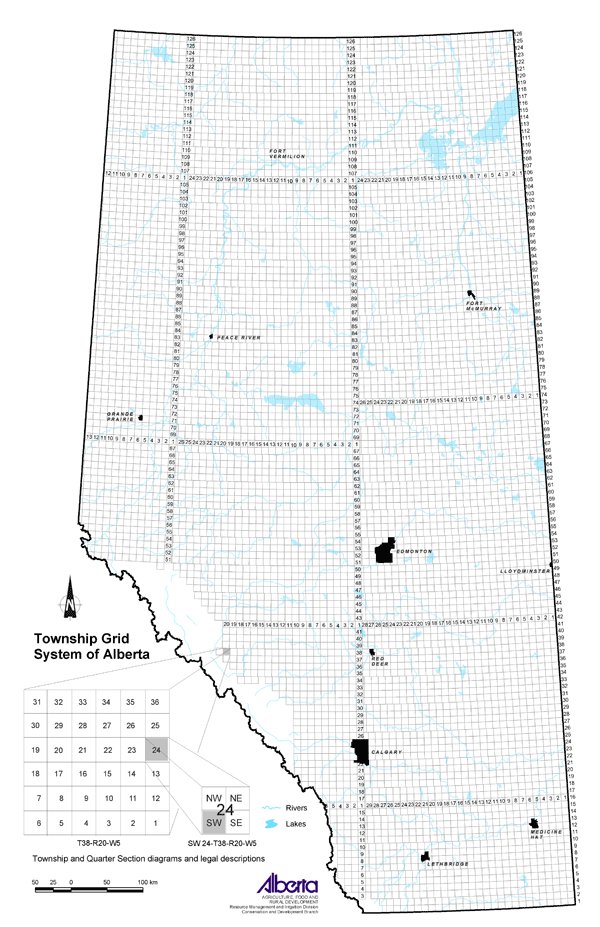
This map represents the province with the Alberta Township System (ATS) overlaid for referencing legal land descriptions in the province. The ATS is a grid network dividing the province into equal-sized square parcels of land, for purposes of administering legal land title. All maps in this Atlas have the ATS overlaid on them.

Data sources

The ATS is a variant of the Dominion Land Survey (DLS) system as implemented in Canada. The digital files containing the provincial coverage of legal subdivision and quarter section linework depicting road allowances, quarter section descriptors and combined scale factors were obtained from AltaLIS Ltd. These two linework products were derived from survey co-ordinates. Further work using these files was done to allow for spatial analysis to be carried out.

Potential Uses

Any section of land in Alberta can be located by its legal land description. Producers and all landowners rely on this system for legal land descriptions.

The ATS designates land as being west of the 4th Meridian (110 degrees west longitude), 5th Meridian (114 degrees west longitude) or 6th Meridian (118 degrees west longitude). Between meridians are a series of columns, each six miles wide, called ranges. They are numbered consecutively from east to west, beginning west of the meridian. Townships are also six miles wide and are numbered from south to north. The southern Alberta border with Montana is township 1, up to the northern border with the Northwest Territories at township 126.

"Township" also describes the six mile by six mile square formed when the range and township lines intersect. These townships are further divided into 36 sections, each measuring one mile by one mile (one square mile). One section contains 640 acres. A section can be further divided into quarters (NE, NW, SE, SW) of 160 acres each or into 16 legal subdivisions (LSDs).

Legal land descriptions are written as in the following example:

SW 24-38-20-W5 - southwest quarter of section 24, township 38, range 20, west of the 5th Meridian.

Further Information

The Alberta Geological Survey website gives further explanation about the ATS. From the homepage, click on GIS Maps, then ATS Conversion Tools in the bar at the right, then Information on the ATS system. http://ags.aer.ca/

AltaLIS Ltd. is the joint venture company that maintains and distributes Alberta's base mapping data sets. www.altalis.com

Range and township road maps for southern and central Alberta are available for sale from Map Town. From the homepage, click on Maps of Canada along the left side, then on Alberta on the map. www.maptown.com.

Click on map for larger view


Other Documents in the Series

 
  Agricultural Land Resource Atlas of Alberta - Preface
Agricultural Land Resource Atlas of Alberta - Municipal Districts and Counties of Alberta
Agricultural Land Resource Atlas of Alberta - Township Grid System of Alberta - Current Document
Agricultural Land Resource Atlas of Alberta - Annual Total Precipitation of Alberta, 1971 to 2000
Agricultural Land Resource Atlas of Alberta - Frost-free Period of Alberta, 1971 to 2000
Agricultural Land Resource Atlas of Alberta - Annual Solar Radiation of Alberta, 1971 to 2000
Agricultural Land Resource Atlas of Alberta - Areal Extent of Wetlands in the Agricultural Area of Alberta
Agricultural Land Resource Atlas of Alberta - Soil Groups of Alberta
Agricultural Land Resource Atlas of Alberta - Soil Texture of the Agricultural Area of Alberta
Agricultural Land Resource Atlas of Alberta - Saline Soils of the Agricultural Area of Alberta
Agricultural Land Resource Atlas of Alberta - Solonetzic Soils of the Agricultural Area of Alberta
Agricultural Land Resource Atlas of Alberta - Organic Matter Content of Cultivated Soils of the Agricultural Area of Alberta
Agricultural Land Resource Atlas of Alberta - Organic Soils of the Agricultural Area of Alberta
Agricultural Land Resource Atlas of Alberta - Water Erosion Risk of the Agricultural Area of Alberta
Agricultural Land Resource Atlas of Alberta - Wind Erosion Risk of the Agricultural Area of Alberta
Agricultural Land Resource Atlas of Alberta - Aquifer Vulnerability Index for the Agricultural Area of Alberta
Agricultural Land Resource Atlas of Alberta - Fertilizer Expense Index for the Agricultural Area of Alberta
Agricultural Land Resource Atlas of Alberta - Chemical Expense Index for the Agricultural Area of Alberta
Agricultural Land Resource Atlas of Alberta - Manure Production Index for the Agricultural Area of Alberta
Agricultural Land Resource Atlas of Alberta - Cultivation Intensity Index for the Agricultural Area of Alberta
Agricultural Land Resource Atlas of Alberta - Number of Species at Risk in Alberta
Agricultural Land Resource Atlas of Alberta - Surface Water Quality Risk for the Agricultural Area of Alberta
Agricultural Land Resource Atlas of Alberta - Groundwater Quality Risk for the Agricultural Area of Alberta
Agricultural Land Resource Atlas of Alberta - Soil Erosion Risk for the Agricultural Area of Alberta
Agricultural Land Resource Atlas of Alberta - Air Quality Risk for the Agricultural Area of Alberta
Agricultural Land Resource Atlas of Alberta - Biodiversity Risk for the Agricultural Area of Alberta


Share via AddThis.com
For more information about the content of this document, contact David Spiess.
This document is maintained by Jennifer Rutter.
This information published to the web on September 1, 2005.
Last Reviewed/Revised on January 29, 2018.