| | Description | Data sources | Potential uses | Limitations | Further information | Download spatial information
Description
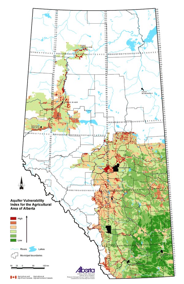
The Aquifer Vulnerability Index (AVI) is a method for assessing the vulnerability of aquifers to surface contaminants. An aquifer is a geologic formation that is permeable enough to transmit sufficient quantities of water to possibly support the development of water wells. In the assessment of aquifer vulnerability to potential contamination, the depth to the aquifer and the types of geological materials above them are considered. For example, aquifers closer to the surface overlain with pervious surface materials are more vulnerable to contaminants, as compared to aquifers found deeper and covered with thick layers of impervious materials.
The AVI ratings indicate the potential of surficial materials to transmit water with contaminants to the aquifer over a period of time. The AVI ratings are displayed on the map in classes ranging from low to high. An area with a low class rating implies that water percolating through the surficial materials in this area takes a long time (in the range of thousands of years) to reach the aquifer. On the other hand, in an area with a high rating, contaminated water is predicted to reach the aquifer within "tens" of years.
Data Sources
This map was generated using two steps. The first step in generating the Index incorporated the AVI prepared by Prairie Farm Rehabilitation Administration (PFRA) and Alberta Agriculture and Food (AF). Dash and Rodvang (2000) prepared Groundwater Vulnerability maps for the Hog Environmental Management Strategy (HEMS) Initiative. The methodology was further developed in Agriculture and Agri-Food Canada Technical Bulletin 2001-1E (Eilers and Buckley (eds.) 2002).
The AVI method maps the vulnerability of aquifers to contamination from the surface, with aquifers nearest to the surface generally the most at risk to contamination. Vulnerability is based on the thickness (depth to aquifer) and the estimated hydraulic conductivity of the geologic layers above the aquifer.
The data used for the AVI comes from Alberta Environment's Groundwater Information Center database that contains general groundwater information from water-well descriptions called well logs. This data was standardized and interpreted for mapping purposes.
The surficial geology maps for southern and central Alberta prepared by Shetsen (1987 and 1990) provided the basis for the polygon lines for amalgamating the interpreted well log data. PFRA also developed a surficial geology map to cover the Peace River region of the province.
The second step in developing the map involved incorporating precipitation minus potential evapo-transpiration (P - PE) values taken from the National Ecological Framework for Canada ecodistrict climate files into the final index. Aquifers in areas with a higher precipitation minus potential evapo-transpiration value are considered to be more susceptible to contaminants through leaching to the groundwater. Inclusion of climate data as a component of the final rating acknowledges the contribution of groundwater recharge through precipitation to the vulnerability of aquifers. Integrating the groundwater vulnerability and precipitation data together resulted in the final AVI ratings (low to high) displayed on the map.
Potential Uses
The AVI is an indication of how much an aquifer is vulnerable to contamination by considering the depth to the aquifer, the surficial geology and groundwater recharge through precipitation.
Limitations
This map should be used as a guide for the relative differences in aquifer vulnerability in the province at a regional level.
Further Information
Groundwater Assessment Reports available from PFRA provide information on the yield, quality and depth of aquifers in Alberta. From the PFRA website, use the topic bar on the left and click on Clean Water, then Water Supply and in that document, click on Groundwater assessment reports in Alberta. www.agr.gc.ca/pfra
Agricultural Region of Alberta Soil Inventory Database (AGRASID) version 3.0 is a standardized compilation of all soil survey information for the province. It portrays soils, surficial geology, landforms and depth-to-bedrock data at a scale of 1:100 000 and is available to download from the AF website. www.agric.gov.ab.ca/asic
General information about groundwater vulnerability can be found at the AF website; use the topic bar on the left and follow: Soil/Water/Air, Water Quality and Groundwater. www.agric.gov.ab.ca
Dash, T. and Rodvang, J. 2000. HEMS Thematic Mapping - Test Data Alberta. Draft analysis approach, preparation of "Groundwater Vulnerability" Maps for HEMS Initiative. CD. December 19, 2000. PFRA and AF.
Eilers, R.G. and Buckley, K.E. (eds.). 2002. A Methodology for Evaluating Soils, Landscapes and Geology for Nutrient Management Planning in the Prairie Landscape - A systematic approach to land based decision making with standardized resource databases, digital map information, manure management research and farm practices guidelines using GIS as a decision tool. Technical Bulletin 2001-1E Land Resource Group, Research Branch, Agriculture and Agri-Food Canada.
Ecological Stratification Working Group. 1995. A National Ecological Framework for Canada. Agriculture and Agri-Food Canada, Research Branch, Centre for Land and Biological Resources Research and Environment Canada, State of the Environment Directorate, Ecozone Analysis Branch, Ottawa/Hull. Report and national map at 1:7 500 000 scale. sis.agr.gc.ca/cansis/nsdb/ecostrat/district/climate.html.
Shetsen, I. 1987. Quaternary Geology, Southern Alberta. Alberta Research Council. Scale 1:500 000.
Shetsen, I. 1990. Quaternary Geology, Central Alberta. Alberta Research Council. Scale 1:500 000.
Click on map for larger view
Download Spatial Information
Agricultural Land Resource Atlas of Alberta - Aquifer Vulnerability Index for the Agricultural Area of Alberta
|
|