| | Description | Data sources | Potential uses | Limitations | Further information | Download spatial information
Description
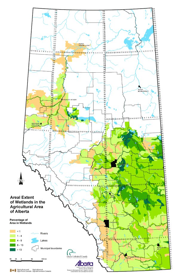
This map displays the density of wetland habitat in the agricultural region of Alberta. Wetlands are depressional areas that are wet for a long enough period that the plants and animals living in them are adapted to, and often dependent on, living in wet conditions for at least part of their life cycle. In drier areas of the province, wetlands tend to be more intermittent, while in wetter areas, wetlands tend to be more persistent. Topography also affects the occurrence of wetlands. Hummocky landscapes allow for pooling of water in depressions, while landscapes with longer slopes (e.g. the foothills) generally have better defined surface drainage patterns. A wetland is influenced by the interaction between the wet area, the wetland margin and upland area.
The map is based on the areal extent of wetlands in each Soil Landscapes of Canada (SLC) polygon. The area of wetlands as a percentage of the total area of the SLC is displayed on the map using the following classes: less than 1, 1 to 4, 4 to 8, 8 to 13 and greater than 13.
Data Sources
The data for this map is derived from Ducks Unlimited Canada's wetland database. The database used satellite imagery acquired in early to late May from 1982 to 1987. May satellite imagery was used to capture spring conditions at their wettest.
SLC Version 1.9 was used for this map. SLC polygons were created using existing soil survey information. Each polygon is described by a standard set of soil and land attributes that characterizes the soil landscapes found in each SLC polygon. Soils, landscapes and climate are the key natural resource factors that determine agricultural productivity, and the farms within a soil landscape unit usually have similar production characteristics.
Potential Uses
Wetlands provide important habitat for waterfowl and many other types of wildlife. Wetlands reduce the impact of flooding, provide erosion control, purify water by removing sediment and nutrients, and contribute to groundwater recharge.
Being aware of where wetland densities are greater reveals areas where beneficial management practices may be used if there are multiple land use issues. For example, fencing off wetland areas to prevent livestock from using these areas for watering or grazing may be an option. Areas of lower wetland density may indicate where special care should be taken to preserve remaining wetlands.
Limitations
The map displays the percentage of the SLC that is covered by wetlands, but this does not reflect the total number of wetlands or the size of individual wetlands within the SLC.
Further Information
Ducks Unlimited Canada www.ducks.ca
Canadian Soil Information System (CanSIS) provides soils information and data including information about SLCs. From the CanSIS website under Data, click on Soil Landscapes on the left side topic bar. http://sis.agr.gc.ca/cansis
Click on map for larger view
Download Spatial Information
Agricultural Land Resource Atlas of Alberta - Areal Extent of Wetlands in the Agricultural Area of Alberta
|
|