| | What is groundwater? | Types of aquifers in Alberta | Groundwater movement | Groundwater recharge | Factors Affecting groundwater quality | Geology and groundwater supplies
Understanding Groundwater
Groundwater is a priceless resource lying beneath most of Alberta’s land surface. About 90 percent of rural Albertans rely on groundwater for a household water supply. Reliance on groundwater continues to increase in rural Alberta because of the steady increase in livestock populations and groundwater requirements for oil recovery purposes. Because it is a “hidden” resource, groundwater is vulnerable to overuse and water quality degradation. This module provides basic information about how groundwater occurs below the ground surface that will help understand how to use and protect groundwater in a manner that will ensure plentiful supplies ermain for future generations.
What is Groundwater?
Groundwater is one component of the earth’s water cycle. The water cycle, called the hydrologic cycle, involves the movement of water as water vapour, rain, snow, surface water and groundwater. The earth’s water is constantly circulating from the earth’s surface up into the atmosphere and back down again as precipitation (see Figure 1, Hydrologic Cycle).
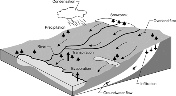
Figure 1 Hydrologic Cycle
Some precipitation that falls to the ground surface infiltrates the ground and becomes groundwater. Groundwater is defined as sub-surface water that fills openings and pore spaces in soil and rock layers. Below the ground surface is an unsaturated zone, which water travels through, to reach lower zones. The water table is the point at which the ground is completely saturated. Below this level the pore spaces between every grain of soil and rock crevice completely fill with water.
Aquifers and aquicludes
The layers of soil and rock below the water table are classified in two broad categories:
Aquifers are water bearing layers (or formations) that yield water to wells in usable amounts. Typical aquifers are made of sand, gravel or sandstone. These materials have large enough connected pore spaces between grains that water moves freely. Coal and shale are more tightly compacted but may also be suitable aquifer materials if they are fractured (or
cracked) enough to allow water to move through them.
Aquicludes are water bearing formations that cannot yield adequate water for wells. Examples of these are clay and unfractured shale and coal. The pore spaces between grains of these materials are so small that water moves through them extremely slowly.
Confined and unconfined aquifers
Unconfined aquifers are exposed directly to the atmosphere through openings in the soil. The volume of water in unconfined aquifers is mainly dependent on seasonal cycles of precipitation that refills the aquifer. A water table aquifer is an example of an unconfined aquifer (see Figure 2, Types of Aquifers).
A confined aquifer is trapped below an upper confining layer of rock, clay or shale. When a well is drilled into a confined aquifer, the water level in the well rises above the upper boundary of the aquifer. Aquifers that are completely saturated with water and under pressure are called artesian aquifers. The artesian aquifer shown in Figure 2, Types of Aquifers, is an example of a confined aquifer. A flowing artesian well results when the pressure in the aquifer raises the water level above the ground surface.
Types of Aquifers in Alberta
There are two main types of aquifers in Alberta:
The amount of water available in each type varies depending on the geological makeup of the area.
Surficial aquifers are shallow sand and gravel aquifers that typically occur between 10-30 m (33-100 ft.). They are important sources of water for many parts of Alberta. Buried valleys are much like our river system. In Alberta, there is a vast network of interconnected valleys located beneath the land surface. These buried valleys appear to have been carved into the upper portion of the underground rock formations and sometimes contain extensive deposits of sand and gravel. They range in depth from 15-90 m (50-300 ft.) and in width from under .4 km (1/4 mi.), to over 16 km (10 mi.).
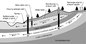
Figure 2 Types of Aquifers
They can offer excellent sites for high yielding wells that can produce up to 500 gallons per minute (gpm). Consequently, there has been considerable effort by hydrogeologists and licensed water well contactors over the past 10 to 20 years to identify the locations of these high yielding aquifers. It is expected that in years to come these buried valleys will become a major source of water supply for agricultural and industrial purposes throughout the province. If the exact locations, yield and water quality of these sources were known, community wells and pipelines could replace individual dugouts and marginal wells in areas with little other groundwater. Properly managed pipelines from wells tapping into these formations would ensure a long-term water supply.
Bedrock aquifers in Alberta are usually composed of sandstone, fractured shale and coal. These aquifers are generally sufficient for most domestic needs; however, larger livestock operations often struggle to meet all of their water requirements from wells drilled into bedrock aquifers. Fractured shales and coals are generally much lower yielding than
sandstone (shale and coal yield <1 to 30 gpm; sandstone yields 1 to 500 gpm). Sandstone aquifers that yield more than 50 gpm are limited to a small portion of the province. These few high yielding aquifers are often tapped for municipal use.
Groundwater Movement
Groundwater is continually moving, but generally very slowly. Gravity is the major driving force and thus groundwater is always moving from areas of higher elevation to lower elevation. Notice the water table in Figure 2, Types of Aquifers, is not level. It slopes toward the stream indicating groundwater moves in that direction. The water in the Artesian
(confined) aquifer is also moving away from the area of higher elevation due to gravity. Knowing the direction of groundwater movement is increasingly important because of the danger of contaminating groundwater supplies. Shallow water table aquifers are especially susceptible to surface contaminants such as sewage, manure, pesticides and petroleum products when they enter the ground at higher elevations, or upslope from the well. Proper
well location and separation distances from potential contaminants reduce this risk.
Groundwater Recharge
Aquifers can be recharged (or refilled) directly by precipitation moving down through the soil and rock layers and into these water bearing formations. They can also be recharged by infiltration from surface water sources such as lakes, rivers, creeks and sloughs. Conversely, groundwater may discharge to surface water sources. The quantity of groundwater discharge may be a significant portion of input into the surface water source and can affect water quality accordingly.
Natural groundwater recharge is affected by human activities on the ground surface. For example, the drainage of sloughs removes water that would have infiltrated to eventually become groundwater. A reduction in groundwater recharge can seriously reduce the water level in nearby shallow wells. This groundwater/surface water interaction must be carefully
considered because the development of either resource will affect the quantity and quality of the other.
Factors Affecting Groundwater Quality
An understanding of the factors that affect groundwater quality can help you make decisions on well depth and the best water quality for a particular application. There are several factors that affect groundwater quality:
- Depth from ground surface
- Permeability and chemical makeup of the sediments through which groundwater moves
- Climatic variations.
Depth from surface
Water is the world’s greatest and most abundant solvent. It attempts to dissolve everything it comes in contact with. As a result, the longer groundwater takes to move through the sediments, the more mineralized it becomes. Thus, shallow groundwater aquifers have a lower level of mineralization, or total dissolved solids (TDS), than deeper aquifers. Water from deeper groundwater aquifers typically has a much longer trip to its destination and thus it is usually more mineralized.
| Total dissolved solids (TDS) means the quantity of dissolved minerals in the water |
While shallow wells have lower levels of TDS, they do have higher levels of calcium, magnesium and iron than deeper wells. High levels of these minerals make the water “hard.” Deeper wells have higher levels of sodium and lower levels of hardness, making the water “soft.” The reason is that deeper sediments and rock formations contain higher levels of sodium and as water moves downward through the sediment and rock formations, a natural ion exchange process occurs. Calcium, magnesium and iron in the groundwater are exchanged for sodium in the sediment and rock formations. The result is groundwater with higher levels of sodium and little or no hardness. The process is identical to what occurs in an automatic water softener, except in this case, it is a natural phenomenon.
Permeability of sediments
Groundwater is stored in the small spaces between particles that make up the sediment and rock formations. These pore spaces are interconnected and groundwater moves slowly through them. Permeability is a measure of the ease with which groundwater travels through the pore spaces. Groundwater moves very slowly through sediments with low permeability, such as clay. This allows more time for minerals to dissolve. In contrast, sediments with high permeability, such as sand, allow groundwater to move more quickly. There is less time for minerals to dissolve and thus the groundwater usually contains lower levels of dissolved minerals.
There is also a difference in dissolved solids between groundwater in recharge zones and water in discharge zones. Recharge zones are uplands areas where precipitation readily enters the ground through permeable, sandier sediments. Generally, water in recharge zones has a low level of mineralization. Discharge areas are low areas where groundwater flow eventually makes its way back to (or near) the ground surface. Groundwater found in such areas can be extremely high in minerals such as sodium, sulfates and chlorides. Examples are saline seeps, sloughs and lakes.
Chemical makeup of sediments
Another factor affecting groundwater quality is the chemical makeup of minerals. Some chemicals are more soluble than others, making them more likely to become dissolved in the water. For example, groundwater in contact with sediments containing large concentrations of sodium, sulfate and chloride will become mineralized at a faster rate than if other
chemicals were present.
| A basic understanding of the factors that affect groundwater quality can help you make decisions on well depths and the best water quality for a given application. |
Climatic variations
Climatic variations such as annual rainfall and evaporation rates also play an important role in groundwater quality. In semi-arid regions discharging groundwater often evaporates as it approaches the surface. The minerals from the water are deposited in the soil, creating a salt buildup. Precipitation infiltrating through the soil can redisslove the salts, carrying them back into the groundwater. For example, in east central and southern Alberta where annual precipitation is from 25-40 cm (10-16 in.) and the evaporation rate is high, TDS are about 2500 parts per million (ppm). In areas with higher precipitation and lower evaporation rates, precipitation that reaches groundwater is less mineralized. For example, in western Alberta where annual precipitation is more than 45 cm (18 in.) groundwater in surficial deposits contains less than 800 ppm of TDS.
Geology and Groundwater Supplies in Alberta
Alberta is divided into four main geological areas: the interior plains, mountains, foothills and the crystalline shield of northeastern Alberta. The same factors that affect water quality also affect the quantity of water available. The
following table shows the high variability in potential yield of water, given the soil and rock formations found in the four geological areas. The mountains and foothills are grouped together in this chart.Alberta is divided into four main geological areas: the interior plains, mountains, foothills and the crystalline shield of northeastern Alberta.
| Soil and Rock Formations | Interior Plains | Mountains and Foothills | Crystalline Shield of N.E. Alberta |
| Shales | <1 to 20 gpm (if fractured) | <1 to 20 gpm (if fractured) | <1 gpm |
| Sandstones | 1-500 gpm | 1 to 100 gpm | <1 gpm |
| Siltstones | <1-5 gpm | <1-5 gpm | Not present |
| Coal | Dry - 30 gpm | Dry - 30 gpm | Not present |
| Limestones | Dry - 30,000 gpm at points of discharge (springs) | Dry - 30,000 gpm at points of discharge (springs) | Not present |
| Dolomites | Dry - 50 gpm northeastern plains | Dry - 15,000 gpm at points of discharge (springs) | Not present |
Evaporites
- Gypsum
-Halite
-Anhydrite | Dry | Dry | Not Present |
| Crystalline Rocks | Present only in extremely limited areas | Variable yield | About 5 gpm |
| Sand and Gravel | <1 - 500 gpm locally in some buried channels | <1 - 500 gpm | Up to 100 gpm locally |
| Clays | <1 | <1 | <1 |
Source: Alberta Research Council -- General Review of Geology As It Relates to Groundwater in Alberta. |
|