| | Land systems data capture | Soil landscape data capture
Use this link to return to the Soil Inventory Procedures Manual
The purpose of this section is to describe the field definitions and data capture rules in detail and to provide the data tables of allowable attribute codes. The attributes collected for Land Systems and Soil Landscape compilation is described in detail in the following sections.
�
Land Systems Data Capture
The Land Systems data is captured on the Land Systems Data Form.
�
Land system number
Land Systems are numbered to show the hierarchical classification of ecoregion, ecodistrict (LRA) and land system. The LRA (Ecodistricts) map is illustrated (Figure 4.1) and the legend is presented in Table 4.1. The Land System number has the following notation:
Field Definition:
| Land System Number | 16.4b.03 |
- �Enter the land system number as provided in the above example, where:
16 = Ecoregion
4b = Ecodistrict (LRA)
03 = Land System number
Attribute Coding Rules:
- The Land System number is a concatenation of Ecoregion, Ecodistrict and the Land System Number.
- This number will start at 1 for each Ecodistrict and end at the appropriate number of Land Systems in that given Ecodistrict.
- Land System numbers are unique but a Land System can be composed of more than one polygon (Figure 4.2).
- River valleys will break at the Ecoregion but will cross Ecodistricts and will be coded with a 00 (example 16.00.1).
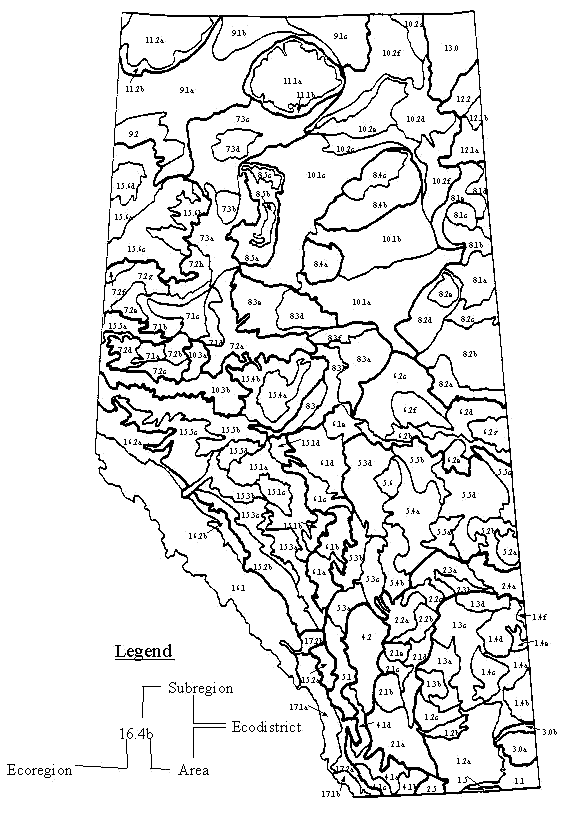
Figure 4.1� Ecodistricts of Alberta (Pettapiece pers. Comm. 1993)
�
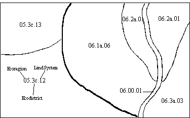
Figure 4.2� Land System map illustrating Land Systems in two Ecoregions (05 and 06), and a Land System (06.2a.01) with two polygons.
Analyst name and date
Attribute Coding Rules:
- enter the analyst name and date (year/month/day)
Table 4.1 Ecodistricts Legend (Ecological Stratification Working Group 1995).
| Ecodistrict�Symbol | Ecodistrict Name | Landform | Texture | Soils | Agroclimate |
| 01.1 | Wild Horse | H-U | CL-SL | BR-SS | 3A |
| 01.2a | Foremost | U(H) | L-SiL | BR | 3A |
| 01.2b | Purple Springs | U | SL(S) | BR | 3A |
| 01.2c | Vauxhall | U | L(SL) | BR | 3A |
| 01.3a | Brooks | U | SiL-SL(S) | BR(SS) | 3A |
| 01.3b | Bow City | U | L to CL | SS-BR | 3A |
| 01.3c | Berry Creek | U | L to CL | SS(BR) | 3A |
| 01.3d | Sounding Creek | U | SL-L | SS(BR,DB)? | 3A |
| 01.4a | Bindloss | U(H) | S-L | BR | 3A |
| 01.4b | Schuler | H-U | L to CL | BR | 3A |
| 01.4c | Rainy Hills | H(U) | L(SL) | BR | 3A |
| 01.4d | Oyen | H(U) | L to CL | BR(DB) | 3A(2A) |
| 01.4e | Acadia | U | C | BR | 3A |
| 01.4f | Sibbald | U | SiC-SiL | BR | 3A |
| 01.5 | Sweetgrass | U-M | L-CL | DB | 2AH |
| 02.1a | Lethbridge | U(L) | SiL(SiC) | DB | 2A |
| 02.1b | Vulcan | U(M) | SiL | DB | 2A |
| 02.1c | Blackfoot | U | SL(L) | DB | 2A |
| 02.1d | Majorville | H | L to CL | DB | 2A |
| 02.1e | Standard | U(M) | SiL-SiC | DB | 2A |
| 02.2a | Drumheller | U-M | C | DB | 2AH |
| 02.2b | Wintering Hills | H(U) | L to CL | DB(BL) | 2AH |
| 02.2c | Endiang | H(U) | L to CL(SL) | DB | 2AH |
| 02.3a | Castor | U(L) | L to CL | SS(DB) | 2AH |
| 02.3b | Sullivan Lake | U | SL-L | SS(DB) | 2AH |
| 02.4a | Neutral Hills | H(S,U) | L-CL | DB | 2AH |
| 02.5 | Milk River | H(U) | CL(SL) | DB | 2AH |
| 03.0a | Cypress | S(L) | L | DB-BL | 2AH-3H |
| 03.0b | Mcalpine | U-H | L to CL | DB | 2A |
| 04.1a | Cardston | U | U(H) | BL | 2AH-3H |
�
Table 4.1 Continued.
| Ecodistrict Symbol | Ecodistrict Name | Landform | Texture | Soils | Agroclimate |
| 04.1b | Del Bonita | H-U | SiL-CL | BL | 2AH |
| 04.1c | Twin Butte | M-S | L to CL | BL | 4H |
| 04.1d | Willow Creek | M-S | L to CL | BL | 4H |
| 04.2 | Delacour | U | SiL-CL | BL | 2AH |
| 05.1 | Black Diamond | M(U) | L to CL | BL-DG | 4H(3H) |
| 05.2a | Provost | U(M) | SiL(SL) | DB | 2AH |
| 05.2b | Edgerton | H(U) | S(SL) | DB | 2AH |
| 05.3a | Olds | U(M) | L to CL | BL | 3H |
| 05.3b | Red Deer | U(H) | L to CL(C,S) | BL-DG | 3H |
| 05.3c | Pine Lake | H(M,U) | L to CL | BL(DG) | 3H |
| 05.3d | Leduc | U(L,H) | L-C(S) | BL(SS) | 2H |
| 05.4a | Daysland | U | L to CL | SS-BL | 2AH |
| 05.4b | Bashaw | H(U) | L to CL | BL | 2AH |
| 05.5a | Sedgewick | U | L to CL | BL(DB) | 2AH |
| 05.5b | Andrew | U | L to CL | BL(SS) | 2AH |
| 05.5c | Lloydminster | U(H) | L to CL | BL | 2AH |
| 05.5d | Vermilion | H(U,M) | L to CL | BL | 2AH |
| 05.6 | Cooking Lake | H | L to CL | GL-DG | 3H |
| 06.1a | Caroline | U(H) | L(SL) | GL | 4H |
| 06.1b | Rimbey | H-U | L to CL | GL-DG | 3H |
| 06.1c | Breton | U-H | CL(C,O) | GL(O) | 4H-3H |
| 06.1d | Lac Ste Anne | H(U) | SiL-CL | GL(DG,O) | 3H |
| 06.1e | Westlock | U | CL(C) | GL(DG,O) | 3H |
| 06.2a | Redwater | U-H | SL(S,L) | DG | 3H |
| 06.2b | Elk Point | U(H) | CL | DG(BL,GL) | 3H |
| 06.2c | Athabasca | U(L) | L to CL(S,C) | GL(DG,O) | 3H(4H) |
| 06.2d | Bonnyville | U(H) | L to CL(SL) | GL(DG) | 3H |
| 06.2e | Myrnam | H | CL(C) | GL(DG) | 3H |
| 06.2f | Whitefish | H(U) | CL(C) | GL(O) | 4H |
| 06.2g | Frog Lake | H(U) | CL | GL(O) | 4H |
| 07.1a | Grande Prairie | L(U) | C | BL-SO(DG) | 2H |
�
Table 4.1 Continued.
| Ecodistrict Symbol | Ecodistrict Name | Landform | Texture | Soils | Agroclimate |
| 07.1b | Rycroft | U-L(H) | C-L | SO-DG(GL) | 2H |
| 07.1c | Dunvegan | U(H) | L(S,O) | GL(BD,O) | 2H(3H) |
| 07.1d | Falher | L | C | SO(DG,GL) | 2H |
| 07.2a | Mclennan | L(U) | CY(L) | SO(GL-DG) | 3H |
| 07.2b | Debolt | U(L) | C(L) | SO(GL,GY) | 3H |
| 07.2c | Smoky | U(H) | S(SL,O) | BD-GL(O) | 3H |
| 07.2d | Beaverlodge | U(L) | C | SO(GL-DG) | 3H |
| 07.2e | Blueberry | U | C(O) | GL(DG,O) | 3H |
| 07.2g | Worsley | L(U) | C(L) | SO(GL,DG) | 3H |
| 07.2h | Grimshaw | U(L) | CL(L,O) | GL(SO,O) | 3H |
| 07.3a | Manning | L | C | SO(GL-DG) | 3H |
| 07.3b | Cache | U | S-SL(O) | BD-GL(O) | 3H |
| 07.3c | High Level | L(U) | C-L(O) | GL(SO,O) | 3H(4H) |
| 07.3d | Boyer | U(H) | SL(S,O) | GL(BE,O) | 3HA |
| 08.1a | Garson | U(H) | SL,CL-O | GL-O(BD) | 4H |
| 08.1b | Steepbank | U(L) | O(S,L) | O(BD,CL) | 4H |
| 08.1c | Muskeg | U(H) | L-O(S) | GL-O(BD) | 4H |
| 08.1d | Firebag | H(U,M) | S(O) | BD(O) | 4H |
| 08.1e | Hart Lake | U(H) | O-S(L) | O-BD(GL) | 4H |
| 08.2a | Pinehurst | H(U) | CL(SL,O) | GL(O) | 4H |
| 08.2b | Mostoos | U(H) | S-O | BD-O | 4H |
| 08.2c | Christina | U(H) | O-S | O-BD | 4H |
| 08.2d | Stony Mtn | M-U | SL(S,O,CL) | GL(O,BD) | 4H |
| 08.2e | Crow Lake | U | O-SL | O-GL | 4H |
| 08.3a | Cross Lake | H(U) | CL(O,SL) | GL(O) | 4H |
| 08.3b | Hondo | U-L | S-O(SL) | BE-O(GL) | 4H |
| 08.3c | Freeman | H(U) | CL(O,SL) | GL(O) | 4H |
| 08.3d | Utikuma | U(H) | CL-O(SL) | GL-O | 4H |
| 08.3e | Heart River | H(U) | CL(O,SL) | GL(O) | 4H |
| 08.3f | Pelican | M(S) | CL-SL(O) | GL(O) | 5H |
| 08.4a | Peerless | H | CL(O,SL) | GL(O) | 5H(4H) |
�
Table 4.1 Continued.
| Ecodistrict Symbol | Ecodistrict Name | Landform | Texture | Soils | Agroclimate |
| 08.4b | Birch | H(M,U) | CL(O) | GL(O) | 5H |
| 08.4c | North Birch | U(M) | O(CL) | O(GL) | 5H |
| 08.5a | Buffalo Head | H(M,U) | CL(O) | GL(O) | 5H(4H) |
| 08.5b | Russell | U-M | CL(O) | GL(O) | 5H |
| 08.5c | Wadlin | U-M | CL(O) | GL(O) | 5H |
| 09.1a | Hay River | L(U) | C-O(CL) | GL-O(GY) | 4H |
| 09.1b | Yates River | L | O(SiC) | O(GL) | 4H |
| 09.1c | Buffalo River | U(H) | O-CL | O-GL,BD | 4H |
| 09.2 | Rainbow Lake | U | CL-O | GL-O | 4H |
| 10.1a | Wabasca | L-U | O-S(CL) | O-BE,GL | 4H (3H) |
| 10.1b | Mackay | L-U | O-CL,SL | O-GL | 4H |
| 10.1c | Loon Lake | L(U) | SiC-O(CL) | GL-O,CY | 4H (3H) |
| 10.2a | Delta | U | L | RE-GY | 4H |
| 10.2b | Salt River | L-U | CL-S | GY-BE(SAL) | 4H |
| 10.2c | Knight Creek | U(R) | S-O | BD-O | 4H |
| 10.2d | Fox Lake | U | O-S | O-BD(GL,GY) | 4H |
| 10.2e | Birch Fans | U-L | CL(C) | GY(GL,O) | 4H |
| 10.2f | Embarras | U | S(O) | BD(O) | 4H |
| 10.3a | Sturgeon | M-U(H) | CL(C,O) | GL(SO,O) | 3H-4H |
| 10.3b | Iosegun | U(M) | C(SL,O) | GL(SO,O) | 4H |
| 11.1a | Caribou | U(M) | O(CL) | O(GLBD) | 5H |
| 11.1b | Caribou Slope | H(S) | CL | GL | 4H |
| 11.2a | Cameron Hills | U(L,M) | O(CL) | O(GL,BD) | 5H |
| 11.2b | Cameron Slope | U | CL(O) | GL(O) | 4H |
| 12.0a | Richardson Hills | H | S(O) | BD(O) | 5H |
| 12.0b | Harrison River | U | O-S | O-BD | 5H |
| 13.0 | Tazin River | H(U,M) | ROCK-(S) | ROCK(BD) | 5H |
| 15.1a | Edson | U(H) | SiC(L,O) | GL(O) | 4H |
| 15.1b | Winfield | H(U) | CL(O) | GL(O) | 4H |
| 15.1c | Cynthia | H(S,U) | CL(S) | GL(BD) | 5H |
| 15.1d | Blueridge | H-U | CL | GL | 5H(4H) |
�
Table 4.1 Concluded.
| Ecodistrict Symbol | Ecodistrict Name | Landform | Texture | Soils | Agroclimate |
| 15.2a | Bragg Creek | M-S | L(S) | DG-BE | 5H |
| 15.2b | Ram River | M-S | L | GL | 5H |
| 15.3a | O'chiese | H-U | CL-L(O) | GL(O) | 4H |
| 15.3b | Obed | H-U | CL-L(O) | GL(O) | 4H |
| 15.3c | Wolf Lake | H(S) | CL-L | GL | 5H |
| 15.4a | Swan Hills | S-M | CL | GL | 5H |
| 15.4b | Driftpile | H-M | CL(O) | GL(O) | 4H |
| 15.5a | Saddle | M(U) | CL(C,O) | GL(O) | 4H |
| 15.5b | Cutbank | M(U) | CL(O) | GL(O) | 5H |
| 15.5c | Berland | M-S | CL | GL(BD) | 5H |
| 15.5d | Mayberne | M-S | CL | GL(BD) | 5H |
| 15.6a | Chinchaga | U(H) | CL,SiC-O | GL-O | 4H |
| 15.6b | Notikewin | U(L) | C(O) | GL(O) | 4H |
| 15.6c | Clear Hills | H(S) | CL(O) | GL(O) | 5H |
| 15.6d | Milligan | H | CL(O) | GL(O) | 5H |
| 16.1a | Banff | SM | L-R | BD-R | 5H |
| 16.1b | Jasper | SM | R-L | R-BD | 5H |
| 16.1c | Icefield | SM | R(L,SNOW) | R(BD) | 5H |
| 16.2a | Willmore | M-S | L(S) | BD-BE(GL) | 5H |
| 16.2b | Luscar | M-S | L | GL-BD | 5H |
| 17.1a | Crowsnest | SM | L(R) | BE(R) | 5H |
| 17.1b | Waterton | SM | L-R | BD,GL-R | 5H |
| 17.2a | Blairmore | H-S | L(CL) | BL-GL(BElit) | 5H |
| 17.2b | Morley | L(M) | L-SL | BL-BE | 4H |
�
�
Soil correlation area
The Soil Correlation Area (SCA) to which the Land System belongs for naming soils is identified by the SCA number (1 to 24) as defined in Alberta Soil Names, Generation 2 Users' Handbook (Alberta Soil Series Working Group 1993).
Field Definition:
Attribute Coding Rules:
- Enter the SCA number
Land system name
Land System names consist of two parts; a geographic locator and a morphological descriptor (e.g. Chin Coulee or Stettler Plain).
Field Definition:
| � | Geographic
Locator | Morphological
Descriptor |
| Land System Name | Chin | Coulee |
Attribute Coding Rules:
Step 1)
Enter a Land System name that reflects a local geographic location.
Step 2)
Select a morphological descriptor from Table 4.2 .
If a morphological descriptor did not exist, the user added a new descriptor.
- Names are not unique across the province.
Table 4.2 List of Morphological Descriptors (Bates and Jackson 1980).
| Descriptor | Definition |
| basin | a. A depressed area with no surface outlet. |
 | b. A low area in the earth's crust where sediments have accumulated. |
| bench | A long, narrow, relatively level or gently inclined strip or platform of land, earth or rock, bounded by steeper slopes above and below and formed by differential erosion of rocks of varying resistance or by a change of base level erosion; a small terrace or step like ledge breaking the continuity of a slope; an eroded bedrock surface between valley walls. |
| bottomland | Low-lying, level land, usually highly fertile (the term signifies a grassy lowland formed by the deposition of alluvium along the margin of a watercourse; an alluvial plain or a flood plain; the floor of a valley. |
| coulee | A dry or intermittent stream valley, gulch or wash of considerable extent; esp. a long steep-walled, trench like gorge or valley representing an abandoned overflow channel that temporarily carried meltwater from an ice sheet. |
| escarpment | a. A long, more or less continuous cliff or relatively steep slope facing in one general direction, breaking the continuity of the land by separating two level or gently sloping surfaces and produced by erosion or by faulting. |
| b. A steep, abrupt face of rock, often presented by the highest strata in a line of cliffs and generally marking the outcrop of a resistant layer. |
| delta | The low, nearly flat, alluvial tract of land at or near the mouth of a river, commonly forming a triangle or fan shaped plain of considerable area. |
| dunefield | Descriptive of an area with numerous low hills or banks of drifted (wind-borne) sand. |
| hill(s) | a. A natural elevation of the land surface, rising rather prominently above the surrounding land, usually of limited extent and having a well defined outline (rounded rather than peaked or rugged) and generally considered to be less than 300m from base to summit; the distinction between hill and mountain is arbitrary and dependent upon local usage. |
| b. Any slightly elevated ground or other conspicuous elevation in an area of rugged relief. |
| c. An eminence of inferior elevation in an area of rugged relief. (d) A range or group of hills, or a region. |
| lowland | a. A general term for low-lying land or an extensive region of low land. |
| b. The low and relatively level ground of a region, in contrast with the adjacent higher country. |
| c. A low or level tract of land along a watercourse. |
| pediment | Gently inclined plannate erosional surface generally veneered with fluvial gravels. |
| plain | Any flat area, large or small, at a low elevation; specif. an extensive region of comparatively smooth and level or gently undulating land, having few or no prominent surface irregularities but sometimes having a considerable slope, and usually at a low elevation with reference to surrounding areas. A plain may be forested or bare of trees, and may be formed by deposition or by erosion. |
| plateau | Any comparatively flat area of great extent and elevation; specif. an extensive land region elevated (more than 150-300m) above the adjacent country; it is commonly limited on at least one side by an abrupt descent, has a flat or nearly smooth surface but is often dissected by deep valleys and surmounted by high hills or mountains, and has a large part of its total surface at or near the summit level. A plateau is usually higher and has more noticeable relief than a plain. |
| upland | a. A general term for high land or an extensive region of high land. |
| b. The higher ground of a region, in contrast with a valley, plain, or other low lying land; a plateau. |
| c. The elevated land above the low areas along a stream or between hills; any elevated region from which rivers gather drainage. |
| valley | a. Any low-lying land bordered by higher ground. |
| b. A broad area of generalized flat land extending inland for a considerable distance, drained or watered by a large river and its tributaries (example Mississippi Valley). |
Surficial geology
The surficial geology of the Land System is identified using the legend modified from Shetsen (1987; 1990) (Table 4.3) which identifies age, mode of deposition, materials and surface form, and relief.
Field Definition:
| Surficial Geology: | 1) | 2a | 2) | 4 | 3) | � |
Attribute Coding Rules:
- Enter up to 3 allowable codes as described in Table 4.3.
- List codes in order of dominance.
Table 4.3. Surficial Geology Legend (Shetsen 1987;1990).
| Epoch | Deposit | Description |
| Pleistocene and Holocene, undivided | | |
| [0] ORGANIC | Woody, fibrous and mucky peat; up to 7 m thick; present in bogs, fens, swamps and marshes; generally flat topography. |
| [1] EOLIAN | Fine and medium-grained sand and silt; up to 7 m thick; longitudinal and parabolic dunes scoured by blowouts; undulating to rolling topography. |
| [2] LACUSTRINE | Sand, silt and clay, with local ice-rafted stones; up to 80 m thick; deposited mainly in proglacial lakes, but includes also undifferentiated recent lake sediment; flat to gently undulating topography. |
| [2a] | Coarse sediment; sand and silt; undulating surface in places modified by wind. |
| [2b] | Fine sediment; silt and clay; flat to gently undulating surface. |
| [3] FLUVIAL | Gravel, sand, silt and clay, includes local till and bedrock exposures; up to 20 m thick; present on floors and terraces of river valleys and meltwater channels, and in deltas; flat to undulating topography. |
| [3a] | Coarse sediment; gravel, gravel and sand, fine to coarse-grained sand, minor silt beds. |
| [3b] | Fine sediment; fine sand, silt and clay, minor gravel beds. |
| [4] STREAM AND SLOPEWASH ERODED | Exposed till and bedrock, local slump material; slopes of river valleys and meltwater channels, in places badland type terrain. |
| Pleistocene | | |
| [5] CRYOTURBATED EOLIAN (LOESS) AND FLUVIAL | Mixed fine sand, silt and gravel, local clay; up to 3 m thick; overlies preglacial gravel and sand on the unglaciated Cypress Hills and Del Bonita uplands; flat to gently undulating topography. |
| [6] ICE-CONTACT LACUSTRINE
| Sand, silt and clay, local till; up to 20 m thick; deposited in supraglacial and ice-walled lakes or in proglacial lakes floored by ice; undulating to hummocky topography. |
| [6a] | Coarse sediment: sand and silt. |
| [6b] | Fine sediment: silt and clay. |
| [7] ICE-CONTACT FLUVIAL
| Gravel, sand, silt and clay, local till; up to 25 m thick; deposited in ice-walled and supraglacial streams, or in ice-front fans and deltas; undulating to hummocky topography. |
| [7a] | Coarse sediment: gravel, gravel and sand, fine to coarse-grained sand. |
| [7b] | Fine sediment: fine sand, silt and clay. |
| [8] ICE-CONTACT LACUSTRINE AND FLUVIAL, UNDIVIDED | Gravel, sand, silt and clay, local till; up to 25 m thick; deposited in intermittent supraglacial lakes and streams; or at margins of ice-floored proglacial lakes; undulating to hummocky topography. |
| GLACIAL ([9] through [12a]) | Till consisting of unsorted mixture of clay, silt and gravel, with local water-sorted material and bedrock; the thickness is generally less than 25 m on uplands, but may reach as much as 100 m in buried valleys; flat, undulating, hummocky or ridged topography. |
| [9] DRAPED MORAINE | Till of even thickness, with minor amounts of water-sorted material and local bedrock exposures; up to 10 m thick; includes local areas of undifferentiated subglacially moulded deposit with streamlined features; flat to undulating surface reflecting topography of underlying bedrock and other deposits. |
| [10] STAGNATION MORAINE | Till of uneven thickness, local water-sorted material; up to 30 m thick; undulating to hummocky topography reflecting variations in till thickness. |
| [10a] | Undulating topography, with local relief generally less than 3 m. |
| [10b] | Hummocky topography moderately to weakly developed, with irregularly shaped and poorly defined knobs and kettles; local relief 3 to 10 m. |
| [10c] | Hummocky topography strongly developed, with generally round, well defined knobs, dimpled knobs, doughnut-shaped hills and kettles; local relief 5 to 20 m. |
| [10d] | Mixed hummocky and moraine plateau topography: flat-topped irregularly shaped hills with a cover of stratified sand, silt, and clay, interspersed with mounds composed of till, local relief 5 to 20 m. |
| [11] RIDGED END MORAINE | Till, gravel and silt; deposited in ridges at or near a glacier margin; up to 15 m thick; typically forms a series of subparallel ridges. |
| [12] ICE-THRUST MORAINE
| Mixed and contorted bedrock, till and water-sorted material that have been translocated by ice in a more-or-less intact state as thrust blocks, or deformed into thrust slabs and folds; up to 100 m thick topography consists of ridges, irregularly shaped hills and depressions. |
| [12a] ICE-THRUST AND STAGNATION MORAINE, UNDIVIDED | Bedrock, till, local water-sorted material; up to 50 m thick rolling to hummocky topography. |
| [13] GLACIAL AND FLUVIAL | Mixed till, sand, silt and gravel, local bedrock exposures; flat to hummocky topography. |
| [13a] | Draped moraine interspersed with fluvial deposit; up to 5 m thick; flat to undulating topography. |
| [13b] | Stagnation moraine interspersed with fluvial deposit; the thickness unknown; rolling to hummocky topography locally strongly modified by stream erosion. |
| Cretaceous, Tertiary and Pleistocene, undivided | | |
| BEDROCK AND GLACIAL, UNDIVIDED | Bedrock, discontinuous till, slump material, minor sand and gravel; flat, undulating, hummocky and ridged topography. |
| [14a] | Draped moraine on bedrock uplands and plains: discontinuous till over bedrock surface slightly modified by ice and stream erosion; till is generally less than 3 m thick; flat to undulating topography. |
| [14b] | Stagnation moraine on bedrock uplands: discontinuous till over bedrock surface strongly modified by ice and stream erosion, till is up to 10 m thick; hummocky to ridged topography. |
| Late Tertiary and early Pleistocene | | |
| [15] FLUVIAL | Gravel and sand, minor silt beds; found overlying bedrock in upland areas, but generally covered by loess or till, and exposed only along crests of the upland slopes. |
| Cretaceous and Tertiary, undivided | | |
| [16] BEDROCK | Sandstone, siltstone, mudstone, and shale, minor ironstone, limestone and coal beds; includes slump material; |
| [16a] | Unglaciated bedrock exposed by erosion. |
| [16b] | Bedrock exposed by erosion or human activities. Surface modified by lake and stream erosion and deposition. Stagnation moraine under a cover of lacustrine sediment. |
Regional surface form models
Information collected for Land System mapping described regional surface forms in general terms (Table 4.4). Soil mappers could record up to three surface forms that described an area.
Table 4.4� Surface Form Models used for Land System mapping�
| Surface Form Model | Symbol |
| Undulating | U |
| Level | L |
| Rolling | M |
| Ridged | R |
| Duned | D |
| Inclined and Undulating | IU |
| Hummocky | H |
| Hummocky and Plateau | HP |
| Hummocky and Ridged | HR |
| Inclined | I |
| Floodplains | FP |
| Stream Channels | SC |
| Peatlands | O |
| Water-Dominated Wetlands | W |
| Disturbed Land | DL |
�
�
Regional bedrock
The regional bedrock type is identified from the Bedrock Map of Alberta (Green 1972)
Field Definition:
�
Attribute Coding Rules:
- Enter one or two codes in order of aerial extent
Lakes and wetlands
The type and abundance of lakes and various kinds of wetlands are coded using a simple classification which was adapted from Miller, 1976.
Field Definition:
| Type | Mineral�Wetlands� | | | | Organic Wetlands | | | | Lakes/Ponds | | | |
| Abundance class | 0 | 5� | �25 | >�
> | 0 | �5� | �25 | >�
> | 0 | 5� | �25 | >�
> |
Attribute Coding Rules:
- Determine type of wetlands present where:
Mineral Wetlands = gleysols and non permanent sloughs
Organic Wetlands = bogs and fens. Areas composed mainly of peat or sedge and organic materials
Lakes/Ponds = permanent water bodies
- Select only one Abundance class for each applicable type, where:
�
0 = none
5 = <5%
25 = 5 to 25%
>> = >25%
Regional soil models
This is a listing of the soils with the greatest aerial extent in the Land System. The soils can be identified by drainage, soil sub group, parent material texture and the till name.
Field Definition:
| Drainage | Soils | Parent Material
Texture | Till Name
� |
| choose from Table 4.5 | choose from
Table 4.6 | choose from Table 4.7 | (depending on the selection under Parent Material Texture, a list of possible till names will appear. Choose a till name according to Soil Names File Gen 2) |
| eg. poorly drained | e.g.. Solonetz | e.g.. F4 | e.g.. Edmonton |
�
Attribute Coding Rules:
Table 4.5� Drainage Categories
| Categories |
| Freely drained (FD) |
| Imperfectly drained (I) |
| Poorly drained (P) |
| Area Ponding (AP) |
�
Table 4.6� Regional Soils
| Soils |
| Brown Chernozemic |
| Dark Brown Chernozemic |
| Thin Black Chernozemic |
| Thick Black Chernozemic |
| Dark Gray Chernozemic |
| Solonetzic Chernozemic |
| Gleyed Chernozemic |
| Gray Luvisol |
| Dark Gray Luvisol |
| Solonetzic Luvisol |
| Gleyed Luvisol |
| Solonetzic |
| Gleyed Solonetz |
| Humic Gleysol |
| Luvic Gleysol |
| Solonetzic Gleysol |
| Undifferentiated Gleysols |
| Organics |
| Regosols |
| Brunisols |
�
Table 4.7 Parent Material Texture
| Codes | Description |
| Coarse textured materials | |
| C0 | Coarse textured (S, LS, SL) material (undifferentiated) |
| C1 | Gravels or gravely (cobbly/stony) coarse textured material |
| C2 | Very coarse (S, LS) sediments deposited by wind or water |
| C3 | Moderately coarse (SL, FSL) sediments deposited by wind or water |
| C4 | Very coarse textured till (Till name) |
| C5 | Moderately coarse textured tills (Till name) |
| C6 | Coarse textured (S, LS, SL) softrock |
| C7 | Coarse grained bedrock |
| Medium textured materials | |
| M0 | Medium textured (VFSL, L, SiL, SiCL, CL, SCL) materials (undifferentiated) |
| M1 | Gravelly medium textured sediments deposited by water (includes cobbly and stony variations |
| M2 | Medium textured (L, VFSL) sediments deposited by wind and water |
M3
| Moderately fine textured (CL, SCL, SiCL) sediments deposited by water |
| M4 | Medium textured (L to CL) till (Till name) |
| M5 | Medium textured (L to CL) softrock |
| M6 | Gravelly and stony medium textured till |
| Fine textured materials | |
| F0 | Fine textured (C, SiC, HC) materials (undifferentiated) |
| F1 | Fine textured (C, SiC) water-laid sediments |
| F2 | Very fine textured (HC) water-laid sediments |
| F3 | Fine textured (C) water-laid sediments with till-like features |
| F4 | Fine textured (C) till (Till name) |
| F5 | Fine textured (C, SiC) softrock |
| Layered materials (change occurs between 30 and 100 cm) | |
| L1 | Gravel or gravelly coarse over medium or fine textured till (includes cobbly and stony variations) |
| L2 | Coarse textured (S, LS, SL) over medium or fine textured till |
| L3 | Medium textured (VFSL, L, SiCL, CL) over medium or fine textured till |
| L4 | Coarse textured over gravel or gravelly coarse (includes cobbly and stony variations) |
| L5 | Medium textured over gravel or gravelly coarse (includes cobbly and stony variations) |
| L6 | Till (Till name) over softrock |
| L7 | Coarse (not till) over softrock L8 - Medium (not till) over softrock |
| L9 | Coarse (not till) textured over fine or very fine (not till) |
| L10 | Medium (not till) textured over fine or very fine (not till) |
| L11 | Peat (any) over coarse textured |
| L12 | Peat (any) over medium textured |
| L13 | Peat (any) over fine textured |
| L14 | Fine textured (not till) over medium to moderately fine textured till |
| L15 | Very fine textured (not till) over medium to moderately fine textured till |
| L16 | Fine to very fine textured (not till) over softrock |
| L17 | Gravelly (includes stony variations) medium textured material over medium or fine textured till |
| L18 | Medium textured material over coarse textured material |
| L19 | Gravelly medium textured material over softrock |
| L20 | Coarse textured over medium or moderately fine (not till) |
| L21 | Gravelly coarse textured over medium or moderately fine (not till) |
| L22 | Fine (not till) over medium (not till) |
| Peat material | |
| P1 | Sphagnum Peat |
| P2 | Fen Peat |
| P3 | Forest Peat |
| Undifferentiated material | |
| U0 | Undifferentiated |
Soil Landscape Data Capture
The following points were some general guidelines for coding attributes for Soil Landscapes.
General
- the system was designed to provide decision assist tools when coding attributes.
- there were mandatory fields that were required to be coded as well as optional fields.
- unique polygon identification was required.
- the analyst entered the basic evidence for a polygon and was able to edit the data as required
- the analyst had the option of importing data from an existing polygon and editing the data.
Soil model
- the order of coding the basic evidence was important. The order in which soils are coded was used to generate a Soil Model.
Landscape model
- the analyst entered an existing Landscape model or entered the data necessary to describe a landscape if a model did not exist.
Soil landscape models
- the analyst entered basic evidence for the polygon. Based on the evidence and a set of rules a Soil
Landscape Model was automatically generated for that polygon.
�
Polygon identification
Field definition and examples:
Attribute coding rules
- Mandatory entry.
- Analysts ensured that the polygon identification numbers were unique.
- Analysts coded the meridian, range, township and polygon number. Polygon numbers could not exceed 99.
Ecological setting
Field definition and examples:
Ecoregion | Ecodistrict (LRA) | Land System Number | SCA |
05 | 5d | 10 | 11 |
Attribute coding rules:
- Mandatory entry for ecoregion, ecodistrict, Land System number and SCA (Table 4.1).
Analyst and correlator
Attribute coding rules:
- Analyst name was a mandatory entry (automatically done).
- For every Soil Landscape polygon coded, a record of the date and name of analyst was stored.
Soil model attributes
Attributes of the Soil Model were captured as basic evidence. The analyst captured only those pieces of evidence that were known. A set of rules were applied to the basic evidence to generate a soil model.
Field definition and examples
�
M: mandatory entry
M*: at least one of the four attributes must be coded
M**: mandatory if soil series is not identified
O: optional entry
Attribute coding rules:
- the basic evidence could be recorded to any level of detail to which the soil analyst was confident.
- the soil model symbol was generated automatically
Attributes:
The analyst coded at least one of the following four attributes:
Soil Series: from Generation 2 Soil Names File
Order: According to the CSSC, Table 4.10
Great Group: According to the CSSC, from Table 4.10
Sub Group: According to the CSSC, from Table 4.10
The analyst coded:
Wetness: Table 4.5
Parent Material: from Table 4.7
Proportion:
a) Dominant (Dom) � 60%
b) Co-Dominant (Co-Dom) � 30 - � 60%
c) Significant (Sig) � 10 - � 30%
Allowable combination of proportions:
a) One dominant soil; up to five significant soils
b) Two co-dominant soils; up to four significant soils
c) Three co-dominant soils (ranked in order of occurrence; one significant soil
The analyst had the option of coding:
Modifier: A modifier of the subgroup, from Table 4.8
Variant: from Table 4.9
Table 4.8 Soil Subgroup Modifiers
| Code | Description |
| NA | Not applicable |
| AC | Acid |
| CA | Calcareous |
| CR | Carbonated |
| DA | Dark Ap or Ah >5 cm |
| EL | Eluviated - has an Ae horizon |
| GM | Grumic |
| PT | Peaty |
| SA | Saline Profile |
| XL | Lithic |
| ZT | Solonetzic B horizon |
�
Table 4.9 Variants
| Code | Description | Code | Description |
| AA | Not modal SCA | XL | Lithic at 30 - 99 |
| AC | Acid | XP | Paralithic at 30 - 99 |
| CA | Calcareous | XS | Sand at 30 - 99 |
| CB | Cobbly | XT | Till at 30 - 99 |
| CO | Coarse | XU | Undifferentiated material at 30 - 99 |
| CR | Carbonated | XZ | Permafrost at 30 - 99 |
| CY | Cryic | YC | Clay at 100 - 200 |
| DA | Dark Ap (cult) | YG | Gravel at 100 - 200 |
| DL | Disturbed | YL | Lithic at 100 - 200 |
| ER | Eroded | YP | Paralithic at 100 - 200 |
| FI | Fine | YS | Sand at 100 - 200 |
| GL | Gleyed | YT | Till at 100 - 200 |
| GM | Grumic | YZ | Permafrost at 100 - 200 |
| GR | Gravelly (entire profile) | ZE | Eluviated |
| OB | Overblown | ZF | Fibric |
| OW | Overwashed | ZG | Gleyed Rego |
| PT | Peaty | ZH | Humic |
| SA | Saline | ZL | Luvisolic |
| SC | Saline Subsoil | ZM | Mesic |
| ST | Stony | ZR | Rego |
| TA | Thin A | ZS | Solodic |
| TK | Thick A | ZT | Solonetzic |
| XC | Clay at 30 - 99 | ZZ | Atypical subgroup |
| XG | Gravel at 30 - 99 | ZB | Brunisolic |
Table 4.10�Order, Great Group & Subgroup Codes for White Area of Alberta
| Order | Great Group | Subgroup Code | Subgroup Name |
| Brunisolic (Brun) | Eutric | O.EB | Orthic Eutric Brunisol |
| | E.EB | Eluviated Eutric Brunisol |
| | GL.EB | Gleyed Eutric Brunisol |
| | GLE.EB | Gleyed Eluviated Eutric Brunisol |
| Dystric | O.DYB | Orthic Dystric Brunisol |
| | E.DYB | Eluviated Dystric Brunisol |
| | GL.DYB | Gleyed Dystric Brunisol |
| | GLE.DYB | Gleyed Eluviated Dystric Brunisol |
| Chernozemic (Cher) | Brown | O.BC | Orthic Brown |
| | R.BC | Rego Brown |
| | CA.BC | Calcareous Brown |
| | E.BC | Eluviated Brown |
| | SZ.BC | Solonetzic Brown |
| | GL.BC | Gleyed Brown |
| | GLR.BC | Gleyed Rego Brown |
| | GLCA.BC | Gleyed Calcareous Brown |
| | GLE.BC | Gleyed Eluviated Brown |
| | GLSZ.BC | Gleyed Solonetzic Brown |
| Dark Brown | O.DBC | Orthic Dark Brown |
| | R.DBC | Rego Dark Brown |
| | CA.DBC | Calcareous Dark Brown |
| | SZ.DBC | Solonetzic Dark Brown |
| | GL.DBC | Gleyed Dark Brown |
| | GLR.DBC | Gleyed Rego Dark Brown |
| | GLCA.DBC | Gleyed Calcareous Dark Brown |
| | GLSZ.DBC | Gleyed Solonetzic Dark Brown |
| Black | O.BLC | Orthic Black |
| | R.BLC | Rego Black |
| | CA.BLC | Calcareous Black |
| | E.BLC | Eluviated Black |
| | SZ.BLC | Solonetzic Black |
| | GL.BLC | Gleyed Black |
| | GLR.BLC | Gleyed Rego Black |
| | GLCA.BLC | Gleyed Calcareous Black |
| | GLE.BLC | Gleyed Eluviated Black |
| | GLSZ.BLC | Gleyed Solonetzic Black |
| Dark Gray | O.DGC | Orthic Dark Gray |
| | R.DGC | Rego Dark Gray |
| | CA.DGC | Calcareous Dark Gray |
| | SZ.DGC | Solonetzic Dark Gray |
| | GL.DGC | Gleyed Dark Gray |
| | GLR.DGC | Gleyed Rego Dark Gray |
| | GLCA.DGC | Gleyed Calcareous Dark Gray |
| | GLE.DGC | Gleyed Eluviated Dark Gray |
| | GLSZ.DGC | Gleyed Solonetzic Dark Gray |
| Gleysolic (Gley) | Luvic | SZ.LG | Solonetzic Luvic Gleysol |
| | FR.LG | Fragic Luvic Gleysol |
| | HU.LG | Humic Luvic Gleysol |
| | FE.LG | Fera Luvic Gleysol |
| | O.LG | Orthic Luvic Gleysol |
| Humic | SZ.HG | Solonetzic Humic Gleysol |
| | FE.HG | Fera Humic Gleysol |
| | O.HG | Orthic Humic Gleysol |
| | R.HG | Rego Humic Gleysol |
| Gleysol | SZ.G | Solonetzic Gleysol |
| | FE.G | Fera Gleysol |
| | O.G | Orthic Gleysol |
| | R.G | Rego Gleysol |
| Luvisolic (Luvi) | Gray | O.GL | Orthic Gray Luvisol |
| | D.GL | Dark Gray Luvisol |
| | BR.GL | Brunisolic Gray Luvisol |
| | PZ.GL | Podzolic Gray Luvisol |
| | SZ.GL | Solonetzic Gray Luvisol |
| | FR.GL | Fragic Gray Luvisol |
| | GL.GL | Gleyed Gray Luvisol |
| | GLD.GL | Gleyed Dark Gray Luvisol |
| | GLBR.GL | Gleyed Brunisolic Gray Luvisol |
| | GLPZ.GL | Gleyed Podozolic Gray Luvisol |
| | GLSZ.GL | Gleyed Solonetzic Gray Luvisol |
| | GLFR.GL | Gleyed Fragic Gray Luvisol |
| Organic (Orga) | Fibrisol | TY.F | Typic Fibrisol |
| | ME.F | Mesic Fibrisol |
| | HU.F | Humic Fibrisol |
| | LM.F | Limno Fibrisol |
| | CU.F | Cumulo Fibrisol |
| | T.F | Terric Fibrisol |
| | TME.F | Terric Mesic Fibrisol |
| | THU.F | Terric Humic Fibrisol |
| | HY.F | Hydric Fibrisol |
| Mesisol | TY.M | Typic Mesisol |
| | FI.M | Fibric Mesisol |
| | HU.M | Humic Mesisol |
| | LM.M | Limno Mesisol |
| | CU.M | Cumulo Mesisol |
| | T.M | Terric Mesisol |
| | TFI.M | Terric Fibric Mesisol |
| | THU.M | Terric Humic Mesisol |
| | HY.M | Hydric Mesisol |
| Humisol | TY.H | Typic Humisol |
| | ME.H | Mesic Humisol |
| | FI.H | Fibric Humisol |
| | LM.H | Limno Humisol |
| | CU.H | Cumulo Humisol |
| | T.H | Terric Humisol |
| | TFI.H | Terric Fibric Humisol |
| | TME.H | Terric Mesic Humisol |
| | HY.H | Hydric Humisol |
| Folisol | HE.FO | Humic Folisol |
| | HU.FO | Humic Folisol |
| | LI.FO | Lignic Folisol |
| | HI.FO | Histic Folisol |
| Regosolic (Rego) | Regosol | O.R | Orthic Regosol |
| | CU.R | Cumulic Regosol |
| | GL.R | Gleyed Regosol |
| | GLCU.R | Gleyed Cumulic Regosol |
| Humic Regosol | O.HR | Orthic Humic Regosol |
| | CU.HR | Cumulic Humic Regosol |
| | GL.HR | Gleyed Humic Regosol |
| | GLCU.HR | Gleyed Cumulic Humic Regosol |
| Solonetzic (Solo)� | Solonetz | B.SZ | Brown Solonetz |
| | DB.SZ | Dark Brown Solonetz |
| | BL.SZ | Black Solonetz |
| | A.SZ | Alkaline Solonetz |
| | GLB.SZ | Gleyed Brown Solonetz |
| | GLDB.SZ | Gleyed Dark Brown Solonetz |
| | GLBL.SZ | Gleyed Black Solonetz |
| Solodized Solonetz | B.SS | Brown Solodized Solonetz |
| | DB.SS | Dark Brown Solodized Solonetz |
| | BL.SS | Black Solodized Solonetz |
| | DG.SS | Dark Gray Solodized Solonetz |
| | G.SS | Gray Solodized Solonetz |
| | GLB.SS | Gleyed Brown Solodized Solonetz |
| | GLDB.SS | Gleyed Dark Brown Solodized Solonetz |
| | GLBL.SS | Gleyed Black Solodized Solonetz |
| | GLDG.SS | Gleyed Dark Gray Solodized Solonetz |
| | GLG.SS | Gleyed Gray Solodized Solonetz |
| Solod | B.SO | Brown Solod |
| | DB.SO | Dark Brown Solod |
| | BL.SO | Black Solod |
| | DG.SO | Dark Gray Solod |
| | G.SO | Gray Solod |
| | GLB.SO | Gleyed Brown Solod |
| | GLDB.SO | Gleyed Dark Brown Solod |
| | GLBL.SO | Gleyed Black Solod |
| | GLDG.SO | Gleyed Dark Gray Solod |
| | GLG.SO | Gleyed Gray Solod |
Landscape model attributes
Landscape models are a conceptual description of a recognizably distinct landscape. The models are used to identify the following characteristics of a landscape:
- surface form (inclined, undulating, hummocky, rolling, etc.).
- slope gradients
- slope lengths
- landform elements
- relief
Surface form can be described and classified by various methods. The most common methods are surface shape (or expression) and geologic landform (which implies method of origin). Table 4.11 illustrates the current list of Landscape Models described by surface form and landform.
Definition:
Attribute coding rules:
- Choose one model for Soil Landscape mapping by entering the appropriate code as defined in Table 4.11.�
Table 4.11 Landscape Models (adapted from Shetsen 1987; 1990).
| �Code | Description | Slope Class(es) |
| Undulating | | |
| U1 | undulating | |
| l. low relief
h. high relief | 2 (1)
2 to 3, 3 |
| Level | | |
| L1 | level plain | 1, 1 to 2 |
| L2 | level and closed basin (depression with raised edges) | 1 to 2 |
| L3 | level and terraced, not within modern stream channels | 2, 2 to 3 with risers |
| Rolling | | |
| M1 | rolling (inclined slopes > 400 m, multi-directional) | |
| m. moderate relief
h. high relief | 4, 4 to 5
5, 5 to 6 |
| Ridged | | |
| R2 | Ridged (includes fluted terrain) | |
| l. low relief
m. moderate relief
h. high relief | 3
4 to 5
5 to 6, 6+ |
| Duned | | |
| D1 | longitudinal dunes | |
| l. low relief
m. mod. relief
h. high relief | 3 to 4, 4
4 to 5, 5
5 to 6, 6+ |
| D2 | parabolic or u-shaped dunes | |
| l. low relief
m. mod. relief
h. high relief | 3 to 4, 4
4 to 5, 5
5 to 6, 6+ |
| Inclined and Undulating | | |
| IU | inclined and undulating | |
| l. low relief
h. high relief | < 5%
> 5% |
| Hummocky | | |
| H1 | hummocky | |
| l. low relief
m. mod. relief
h. high relief | 3 to 4, 4 (3)
4 to 5, 5
5 to 6, 6+ |
| H5 | hummocky draped moraine over softrock | |
| l. low relief
m. moderate relief
h. high relief | 3, 3 to 4
4 to 5
5 to 6 |
| Hummocky and Plateau | | |
| HP1 | hummocky stagnation moraine with nearly-level lacustrine plateaus (morainal lake scenarios) | |
| m. moderate relief
h. high relief | 4 to 5, with 2-3
5 to 6, with 2-3 |
| Hummocky and Ridged | | |
| HR2 | hummocky and ridged | |
| m. moderate relief
h. high relief | 4 to 5
5 to 6, 6+ |
| Inclined | | |
| I1 | inclined plain (slope length > 400 m) | |
| l. low relief | 2 to 3 (2) |
| I3 | inclined to steep, single slope landforms with (includes old RB1 unit, fans, aprons) | |
| l. low relief
m. mod. relief
h. high relief | 3 to 4, 4
4 to 5, 5
5 to 6, 6+ |
| I4 | inclined to steep, single slope landforms with >10% exposed bedrock (includes old RB2 unit) | |
| l. low relief
m. mod. relief
h. high relief | 3 to 4, 4 (3)
4 to 5, 5
5 to 6, 6+ |
| I5 | inclined, steep, with extensive failure slumps (RB5 and ZCV units) | 5 to 6, 6 + |
| Floodplains | | |
| FP1 | meander floodplain | 1 to 2, 2, 2 to 3 |
| FP2 | unconfined braided channel | 1 to 2, 2, 2 to 3 |
| FP3 | confined floodplain, possibly terraced | 2, 2 to 3 (1) |
| Stream Channels | | |
| SC1 | valley with confined floodplain | |
| l. low relief
h. high relief (steep sides) | <9% side slopes
>9% slopes |
| SC2 | wide valley with one or more terraces (coulees included) | |
| SC3 | v-shaped valley with no terraces or floodplain (RB4) | |
| SC4 | sub-glacial channel (intermittently incised) | |
| Peatlands | | |
| O1 | Level, flat, horizontal or plateau | |
| O2 | Basin (bowl) | |
| O3 | Channelled, ribbed or net | |
| O4 | Sloping | |
| O5 | Level organic with hummocky mineral soils | 2, 3-6 |
� Water-Dominated Wetlands (land surface dominated by water)
| Code | Description |
| W1� | channel sloughs and ponds in linear arrangement, no channel banks. Often old ice-walled channel feature.� |
| W2� | Non-aligned aggregation of sloughs/ponds with little inter-slough area. Can have significant inter-water area.� |
| W3� | A single water body basin which may be filled or partly filled with water (greater than 65 ha area).� |
�
Disturbed Land
| Code | Description |
| RR� | reclaimed or reconstructed land� |
| DL� | any disturbed land (urban, gravel pits, areas not suitable for arable crops)� |
| GZ� | Green Zone area (not mapped in the CAESA Project)� |
�
Field definition:
Table 4.12 Soil Landscape Modifiers
| Code | Description |
| d | Dissected (> 50 cm, gully, same position year after year) |
| r | shallow to bedrock (within 5 metres) |
| e | eroded pits (specific to solonetzic landscapes) |
| n | concavities |
| c | Channeled (< 50 cm, rill, re-occur at the same position year after year) |
�
Salt affected
Define presence or absence of salinity (true if salinity is present or false if salinity is absent)
�
Confidence level
The analyst records the level of confidence that they have in the basic evidence (low = 1, medium = 2 or high = 3)
�
Field check required
The analyst records if a field inspection was made in the polygon (true or false). If a field visit was made then the analyst records ‘done’ (entry screens only).
*****[Allowable Codes]������ Legend |
|