| | Preface | Acknowledgements | Additional information
Table of Contents
Preface�
The Canada - Alberta Environmentally Sustainable Agriculture (CAESA) Soil Inventory Project (SIP) was a cooperative project involving the Alberta Research Council; Alberta Agriculture and Food; Agriculture and Agri-Food Canada - Land Resource Unit, and private sector consulting firms. Funding for the project was provided through the CAESA agreement and by the three previously mentioned Federal and Provincial agencies. The product of this project is referred to as AGRASID (Agricultural Region of Alberta Soil Inventory Database). The Land Systems Database is a value-added product of AGRASID.��
Acknowledgments
The Land Systems Database is a product of input and cooperation of many people:���
Conservation and Development Branch, Alberta Agriculture and Food, and PFRA, Agriculture and Agri-Food Canada provided additional funding for the development of the Land Systems Database���
The principal Block leaders of the CAESA Soil Inventory Project coordinated the compilation of the preliminary land system maps and database. These block leaders were: Ron McNeil responsible for southern Alberta region; Larry Nikiforuk responsible for central Alberta region; and Len Knapik responsible for the Peace region of Alberta. These preliminary maps provided the basis for the compilation of the AGRASID Land Systems Database.��
The Land Systems Working Group was responsible for developing the land systems database structure and reviewing the final product. Working group members included Paula Brand, David Gibbens, Alan Stewart of PFRA, Agriculture and Agri-Food Canada; Jan Kwiatkowski, Leon Marciak, of Conservation and Development Branch, Alberta Agriculture, Food and Rural Development, and Tony Brierley and Peter Smith of Research Branch, Agriculture and Agri-Food Canada.��
The numerous people who contributed to the compilation of AGRASID need to be acknowledged for their contribution to the Land Systems Database. They include: James Abramenko, Harry Archibald, Paul Barlott, Sarah Boon, Tony Brierley, Simon Brookes, Adrien Chartier, Daphne Cheel, Brian Chernipeski, Gerry Coen, Carolyn Ewaschuk, Mark Fawcett, Nancy Finlayson, Marianne Gibbard, David Gibbens, Anna Hansen, John Hermans, Mark Johnson, Ed Karpuk, Len Knapik, Jan Kwiatkowski, Jennie Lutz, Bob MacMillan, Leon Marciak, Ron McNeil, Steve Moran, Wayne Pettapiece, Doug Peters, Murray Riddell, Andrew Rodvang, Rieva Rosentreter, Barb Ryley, Brenda Sawyer, Jim Si, Peter Smith, Bill Souster, Arnold Stenger, Al Stewart, Joe Tajek, Conny Tomas, Holly Turner, Gerry Tychon, Hank Van der Pluym, Bruce Walker, Ivan Whitson, Andrew Wooley and Zenon Wozimersky.��
Additional Information�
In addition to this manual, information regarding the CAESA Soil Inventory Project may be obtained from the following documents that are included on the AGRASID CD-ROM:��
1. CAESA Soil Inventory Project Procedures Manual (CAESA Soil Inventory Project Working Group 1997).
2. AGRASID Soil Landscapes User’s Manual (Version 1.0) (Nikiforuk et al. 1998)�
3. Alberta Soil Names File (Gen. 2.5) (Alberta Land Resource Unit 1997b)
4. Alberta Layer File (Gen. 2.5) (Alberta Land Resource Unit 1997a).�
�Copies of the AGRASID CD as well as published soil survey reports are available for purchase from the following address:��
Alberta Agriculture Food and Rural Development��
Publications Office��
7000, 113 Street��
Edmonton, Alberta.��
T6H 5T6��
Toll free number: 1-800-292-5697��
Local : 427-0391��
Chapter 1
Introduction��
Welcome to the land systems component of AGRASID! On the AGRASID (Version 1.0) CD there are some additional files (LS_LEGND.dbf, LS_GENRL.pdf) which are not present on the AGRASID (Pre-release version) CD, of November 1997. These new additional files provide descriptions of landscape units referred to as Land Systems. In simple terms, land systems, as they may be displayed using the AGRASID SL.dbf (Soil Landscape file) or using the AGRASID Viewer, are a systematic amalgamation of the existing soil landscape polygons describing regional scale landscapes. Land systems are intended to be represented at a scale of 1:250 000.��
What are land systems? �
The land systems concept is an integrated survey approach that is used for describing "regional landscapes". This concept has been employed worldwide - by the Australians as a rapid way for assessing the agricultural potential of large areas within the "outback" and by the British Foreign Service as a framework for planning and development projects in Africa.��
Land systems have been defined as "areas of the country in which there is a recurring pattern of soils, vegetation and topography" (Anon 1954). For AGRASID the following definition was used "land systems depict landscapes of recurring, or distinctive patterns of geomorphology, geology, topography, soils and vegetation or land use, to be depicted at a scale of 1:250 000. The minimum size of a land system is 1 township, with the mean size of 3-5 townships" (CAESA-SIP Procedures Manual 1997).��
Within AGRASID, the land systems are assigned to the Ecozones, Ecoregions and Ecodistricts as defined in the National Ecological Framework for Canada (Ecological Stratification Working Group, 1995). Ecodistricts are the smallest unit of this national framework. The AGRASID land systems are subdivisions of these Ecodistricts. The symbol of each land system consists of the unique Ecoregion and Ecodistrict symbols and then the individual land system number.��
For example, a land system symbol looks like "01.2a.17". The "01" refers to the Ecoregion; the "2a" to the corresponding Ecodistrict within Ecoregion 01; and "17" refers to the unique Land System within the Ecodistrict 2a and Ecoregion 01. Therefore land systems are nested and inherently linked to this national ecological framework.��
| Ecological Framework Hierarchy� | Scale of�
Representation� | Symbol�� | Description� |
| Ecozones (National)�� | 1:7.5 M�� | � | Prairies� |
| � Ecoregions (Provincial)�� | 1:5 M� | �02� | �Moist Mixed Grassland� |
| ��� Ecodistricts (Regional)�� | 1:2 M�� | 02.1b�� | Vulcan Plain� |
| ��� LAND SYSTEMS�� | 1:250,000�� | 02.1b.10�� | ENSIGN UPLAND� |
| ������� Soil Landscapes�� | 1:100,000�� | WNY1/U1h� | � |
Figure 1. Relationship of Land Systems to the components of the National Ecological Framework�
The land systems concept��
The land systems concept is an accepted regional scale landscape unit for organizing, summarizing and displaying data from a variety sources as well as being a useful base for attaching external databases in Alberta.�
The land systems concept was an integral step in the compilation of the AGRASID files. As referred to in the Procedures manual, the personnel involved in the development of AGRASID utilized a top down approach. During the creation of the preliminary Land System maps, existing ecological, geological as well as soils information was summarized in a systematic fashion. These preliminary maps were used by the soil analysts so the 1:100K scale soil landscape polygons could be systematically assigned to appropriate land systems, which were already nested within an established and standard hierarchical ecological framework (Ecological Stratification Working Group 1995), during the mapping process. Thus the land systems concept proved a beneficial step to have incorporated within the AGRASID compilation procedures in order to maintain the hierarchical ecological framework soil/landscape data.�
Following the compilation of the AGRASID files, the land systems component required some additional work as well as monetary funds. Justification for carrying out this additional work was based upon users' interest and acceptance of the land systems concept. Existing Land System maps for municipalities, such as the County of Stettler (Brierley et al. 1992), County of Vulcan (Kwiatkowski and Marciak 1994), and the M.D. of Starland (McBride et al. 1995), have proven to be useful planning tools at the regional level. The ability to link farm headquarter Statistics Canada data to these regional landscapes and subsequently summarize land use activities for each land system (Hiley et al. 1994) has been received very favourably by many potential clients. Also for example, municipal scale conservation plans have been developed based upon the Land Systems map for Stettler. Therefore, Conservation and Development Branch of Alberta Agriculture Food and Rural Development and PFRA of Agriculture and Agri-Food Canada supported the development of the Land System database.�
The intended audience for land system maps includes planners, agricultural fieldmen, regional soil conservationists and program managers. These users require soil/landscape information as broad regional theme, which may be integrated with other resource data. Land systems are described in general terms as exemplified by the descriptions found in the AGRASID Viewer. The viewer incorporates the information contained within the general legend file (LS_GENRL.pdf). Users who require specific terminology and soil name codes should refer to the complete land system database file (LS_LEGND.dbf).�
Chapter 2. Land System Database��
��
The inclusion of the land systems component to the AGRASID CD (Version 1.0) resulted in some modifications to the structure of the Soil Landscape Attributes file (SL.dbf), as well as the addition of 2 files to the CD. The additional fields included in the SL.dbf provide a link to the ecological framework and the land systems. Three files are necessary to create a land systems map with a description of the components for each land system. The relationship and common linkages between the files related to the production of land system maps and legend are illustrated in Figure 2.��
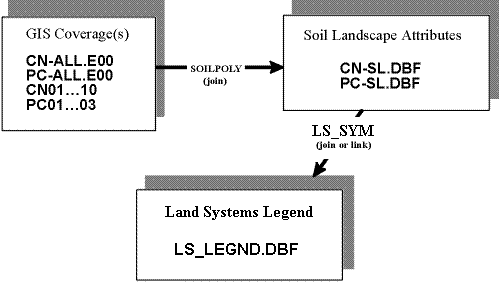
Figure 2. Relationship of the Land System Legend file to SL.dbf and the GIS coverage files.�
The subsequent sections provide brief descriptions of the files related to land systems. In Appendices 1-3 the contents of each file (GIS Coverage, SL.dbf and LS_LEGND.dbf) and each field is briefly described. Where appropriate, a reference is included to either the Procedures Manual, the AGRASID Users Manual, or the Alberta Soil Names File.���
GIS coverage files� ��
The GIS coverage contains the graphical soil polygons. A soil polygon identifier (SOILPOLY), meridian, range, township, area and perimeter information is assigned to each soil polygon. The GIS coverage of soil information is geo-referenced to the 1:20 000 provincial digital base map with a projection of 10 degree Transverse Mercator (10TM), NAD 27. There is one complete coverage for the Central region (CN-ALL.E00) and one for the Peace region (PC-ALL.E00). Each region has also been partitioned into smaller files for users who may not wish to copy the complete coverage onto their system. The Central region is partitioned into ten files: CN01-CN10 (Figure 3). The Peace region is partitioned into three files: PC-01-PC-03 (Figure 4).��
�
Soil landscape attribute files��
The Soil Landscape Attribute Database File (SL.dbf) contains data depicting the ecological attributes, landscape features, and soil landscape model symbol of each soil polygon. There is one file for the Central region (CN-SL.DBF) and one for the Peace region (PC-SL.DBF).��
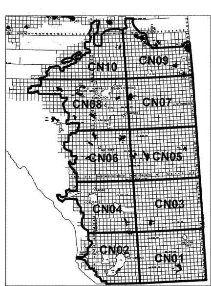
Figure 3. Spatial extent of each partitioned file in the Central region.�

Figure 4. Spatial extent of each partitioned file in the Peace region.�
In order to include the Land Systems component to the existing AGRASID CD (Pre-release version) some additional fields were incorporated within the Soil Landscape Attribute file (SL.dbf).��
��
The following fields were included:��
���� Ecoregion��
���� Ecodistrict��
���� LS_number��
LS_Sym - created by concatenating the values in the Ecoregion, Ecodistrict and� LS_number fields��
Each soil landscape polygon as identified by the "soilpoly" field in the SL.dbf is assigned to a land system. The LS_Sym identifies each unique land system. A land system map is derived by theming on the LS_Sym field. The resulting map displaying land systems are described as being "nested and exact" with respect to the 1:100K scale soil landscape polygons (i.e. the land system boundaries are described by the amalgamation of soil landscape polygons). In a similar fashion Ecodistrict and Ecoregion maps may be produced by theming on the respective fields within AGRASID.���
NOTE: If the AGRASID files are used to develop an Ecoregion and/or Ecodistrict map, the resulting product will not duplicate the National Ecological Framework for Canada (1995) maps for the agricultural region of Alberta. The reason for this discrepancy is due to the fact that these "new ecological areas" are being delineated by the 1:100K scale soil landscape polygons. The land systems are "nested but not exact" with respect to the ecological maps associated with the 1995 National Ecological Framework publication which are intended to be displayed at a scale of 1:1M or smaller.���
Land system description file��
Two files describe the soils and landscape characteristics of the recognized land systems within AGRASID. These files are referred to as the "legend" database file (LS_LEGND.dbf) and the "general" description report (LS_GENRL.pdf). The contents of the files and brief descriptions of the fields are outlined in Appendices 3 & 4.��
��
The LS_LEGND.dbf provides a complete listing of the attributes used to describe/characterize each land system. These attributes are in code, enabling analysis by GIS. Similar to the SL.dbf the LS_LEGND.dbf is subdivided into two files one for the Central region and the other for the Peace region.��
The LS_GENRL.pdf (a portable document file) provides a summary of the "coded data" in text format. This information is incorporated into the Land System viewer so it may be accessed interactively. The intent of this file is to create a hard copy report. It can not be directly linked in a GIS environment.��
Additional files��
The following files that are part of AGRASID provide additional information about the identified soils within each land system. Specifically, the Soil Names and Layer files translate and describe the soil name symbol contained within the Major and Minor soil fields of the LS_LEGND.dbf. The contents of the following files are not included in this manual, but are described in Appendices 4 & 5 of the AGRASID User's Manual.��
��
1. Soil Names File�
The Soil Names File (SNF.DBF) contains information on all the soil names currently recognized within the agricultural region of Alberta. Each soil name is described in terms of; soil classification, parent material type, texture and other accessory characteristics. The version of the Soil Names File provided is current to the date of publishing of AGRASID. However, the file is updated and revised based upon the observations and feedback provided to the Alberta Soils Correlator by soil inventory specialists. The Correlator makes additions and deletions to the file but changes to the database structure are not common.�
��
2. Soil Layer File�
The Soil Layer File (SLF.DBF) contains information on the chemical and physical properties for each soil name listed in the Alberta Soil Names File. Within the SLF the soil horizons (layers) of each soil name are identified as individual records. The fields defined in this file are the minimum data set necessary for interpreting soils for agronomic purposes (Alberta Land Resource Unit 1997a; CanSIS Manual 3 Procedures and Users Guide revised 1994).
Chapter 3. Methodology for Creating the Land Systems Map and Legend�
��
Background
The land system product as viewed on the LS Viewer or derived from AGRASID (Version 1.0) is the result of many peoples' input and subsequent manipulation (correlation and summarization) of data. The land systems map and legend products evolved through a multi step process. In the CAESA-SIP Procedures Manual, the rationale and procedure followed during the creation of the preliminary Land Systems product are described in detail. The subsequent activities including correlation (or "refinement") of the digital land system delineations and creation of the accompanying legend database are described in this chapter.�
Here is a summary of activities which occurred prior to the subsequent correlation and development of the Land Systems database files included on the AGRASID CD (Version 1.0).�
1. Block Leaders of CAESA-SIP created working copy land system maps and accompanying individual descriptions. The development of these maps employed the "top down" approach for stratifying the agricultural region of Alberta landscape in to Land Systems. Each Land System was labeled with a symbol consisting of Ecoregion, Ecodistrict, and land system number.�
2. The Block Leaders compiled a database describing the preliminary land systems. This database contained specific information with respect to symbol, landscape descriptors, surficial materials and expected soil types, etc. Also each land system was assigned a geographic name and morphological descriptor (e.g. Ensign Upland).
3. During the compilation of AGRASID (Pre-release version) the soil analyst delineated and described the attributes of each 1:100K soil landscape polygon and assigned each polygon to a specific land system.
4. Allocation of these soil landscape polygons was based upon the preliminary Land System maps as
compiled by the Block Leader. However, during this step the analyst incorporated some modifications to land system boundaries and land system concepts.�
5. Therefore, the land system map as derived from AGRASID (Pre-release version) varied from the original preliminary land system maps and database as prepared by the Block Leaders.�
6. Next steps include correlation of the land system delineations and development of a legend database. These activities were the responsibility of the Land Systems Working Group.�
The land system products included on the AGRASID (Version 1.0) CD are therefore the result of the following correlation and "roll up" activities. First the land system delineations were correlated with the ecological framework, etc. Then the soil landscape polygon attributes were summarized and organized into a database, similar to a legend. The next two sections outline the procedure for compiling these components of the land system data, as well as correlation and compilation of the land system legend.�
Correlation of the land system delineations��
The land system maps derived from the pre-release version of the AGRASID files often varied from the original preliminary land system maps, prepared by the Block Leaders. Also the associated land system database required modification.�
��
The land system correlation procedure involved comparing the "digital" land systems map with the preliminary version of the land systems map. The land system factors that were considered during this correlation step included:�
- Modifying the boundaries of the land system (determined by the allocation of AGRASID soil landscape polygons) so the land systems are nested within nationally recognized Ecoregions and Ecodistricts as well as provincial scale Soil Correlation Areas (SCA's).�
- Evaluating and justifying the "uniqueness" of neighbouring land systems within Ecodistricts, based upon the soil landscape model symbols, specifically soil types and landscape models.��
- Amalgamating land system polygons that do not meet the minimum size criteria (i.e. not larger than 1 township in size) with it's most "similar" neighbouring land system.�
- Reviewing the allocation of river land systems to Ecoregions. Land systems consisting of a major river (i.e. the North Saskatchewan River) are unique to Ecoregions, (but not Ecodistricts) with respect to their LS_Sym designation.�
Modifying the alignment of land systems within AGRASID meant changes to the corresponding files. For example, amalgamating a land system with it's neighbour required changing the LS_Sym as well as possibly the corresponding Ecoregion, Ecodistrict and LS number fields in the SL.dbf, for all of the soil polygons which comprise the land system.��
�
Compilation of the land system legend database��
Compilation of the land systems legend database was a multi-stepped process. First the structure of the database had to be determined and then populated. The following sections outline some activities that occurred to develop the land system legend database and the general land system descriptions (the LS_LEGND.dbf and LS_GENRL.pdf respectively).��
Structure of the land systems legend database (LS_LEGND.dbf)��
The development of the LS_LEGND.dbf involved many people, primarily members of the Land Systems Working Group. The contents of the legend database consisted of the fields within the preliminary land systems database, based on the descriptions provided by the Block Leaders. This preliminary database contained information based upon existing soil landscape information not upon the AGRASID 1:100K soil landscape polygons and accompanying descriptions. Therefore, the land systems legend for inclusion on the AGRASID CD was generated from new AGRASID soil landscape data.�
��
After reviewing existing land system map legends and soliciting comments of land system map users, members of the Land System Working Group agreed upon the fields within the fields present in the LS_LEGND.dbf. The fields of the LS_LEGND.dbf are listed and briefly described in Appendix 3 of this User's Manual.�
Procedure for populating the land systems legend database file (LS_LEGND.dbf)��
Assembling the land systems legend database initially involved the development of a procedure to "roll-up" the soil and landscape attributes within the other AGRASID files. This procedure was a multi-stepped process:�
�
1. Using the AGRASID files, specifically the GIS Coverage and SL.dbf, determine the areal extent of each soil landscape polygon symbol within each land system. The result is a table for each land system listing the soil landscape symbols and a percentage occupied by that polygon.
2. Based on this table the major and minor soil names were determined by incorporating the areal extent values for each soil name as identified in the MAS.dbf. In the MAS.dbf a dominant, or up to 3 co-dominant soils are identified. Also up to 4 significant soils may be listed. By definition a dominant soil is one that occupies >60% of the polygon. Similarly a co-dominant soil is one that occupies >30 and <60% of the polygon and significant soils occupy >10% and <30%. Based on these definitions the following values were assigned to each soil name using the following values for the areal extent values: Dominant soils = 0.6; Co-dominant soils = 0.3; and Significant soils = 0.1.
3. In order to acquire a listing of all individual soil names that occur in a land system and a relative percentage of the land system each soil occupies, the areal extent values of each soil landscape polygon was multiplied with the arbitrary areal extent values for each soil name.
For example: a soil landscape polygon occupies 50% of a land system, a soil name is dominant then that soil is assumed to occupy 30% (50% times 0.6 = 30%) of the land system.��
4. Based on this list of soil names within each land system, other soil attribute tables were derived. These other attributes included the soil Order, parent material type and texture, as well as combinations of classification and parent material.
5. Using these soil attribute tables for each specific land system, the "major and minor soil" fields were determined and entered within the LS_LEGND.dbf. This exercise was a manual endeavour since some "judgement calls" were required. In some cases the first few values in the summary tables were not automatically the values to be entered into the "major soil" field. For example with respect to the major and minor soils the identified soil names were not necessarily the first five soil names. The "representative" soil names had to be evaluated in terms of the following ranking of importance:
��������� a) Soil order�
��������� b) Subgroup + Parent material�
��������� c) Soil name��
6. The landscape models as listed in the SL.dbf were summarized by land system. and generally the principal features (i.e. hummocky versus inclined or undulating) were considered in the exercise of populating the LS_LEGND.dbf landscape fields.�
7. Other accessory fields in the LS_LEGND.dbf such as WET_AREA and SALINE_AREA are an estimated percentage based upon the areal extent value of ZWA and ZNA miscellaneous soil types as listed in the land system summary tables.
NOTE: Because the "dominant soil" within each soil landscape polygon was assigned a maximum value of 0.6, the maximum value within the WET_AREA and SALINE AREA is 60%. In some cases these may be misleading. For example, the WET_AREA value for Pigeon Lake land system is 60%, whereas in reality it should be closer to 100%.�
Procedure for creating the general land system description (LS_GENRL.pdf)��
The land system legend database with its coded attribute descriptions is primarily suited for GIS and database applications. For users who prefer a simplified explanation, a generalized text description of each land system is provided in LS_GENRL.pdf. The text expressions have been derived directly from the LS_LEGND.dbf and employ the coded data and lookup tables to generate the text expressions for each land system. The following steps describe how the text descriptions were constructed.
1.���� A series of look up tables were devised to convert the code or symbol within the land system database to a string of text. In some cases this was basically a one to one relationship. In other cases, the codes were "amalgamated" into fewer classes to describe land system attributes. For example, 66 landscape models used in Agrasid to describe landscapes at a scale of 1:100,000 were simplified to 26 representative landscape descriptions. In a similar fashion additional lookup tables for the other soil components such as Soil Zone, Soil Order and Parent Material Texture were created and used in compiling the LS_LEGND.pdf. The conversion tables for these various components are listed in Appendix 4, Tables 1-5.��
2.���� Landscape is the first attribute described in the general land system description. The landscape attribute may have from one to three separate surface forms defined in the� LS_LEGND.
Attribute: | Landscape |
Code: | H1m |
Description: | hummocky |
�"Landscape" is hummocky.���
3.���� A description of the representative soils within each land system is generated in terms of Soil zone, Order and parent material.�
Attribute: | Soil Zone | Soil Order | Parent Material Texture� |
Code: | 1 | CH | M4 |
Description: | Brown | Chernozems | medium textured till |
Brown Chernozems developed on medium textured till."�
4.���� Many land systems have more than one surface form and/or multiple soils identified in the LS_LEGND. These various combinations of attributes are accommodated by adding phrases such as "and" or "with some":�
"Landscape is hummocky with some peatlands. Dark Gray Luvisols and Organics developed on very fine textured water-laid sediments and sphagnum peat."��
5.���� Minor soils that are distinctly different from the identified major soils are included in the general description. If the order of any of the minor soils is different from order of the major soils, then the following statement is added that includes the different soil order such as:��
"Minor soils include Regosols."�
6.���� If the texture of a minor soil is strongly contrasting, and is identified as coarser, finer or gravellier than the major soils, the following statement is added or appended to the minor soils statement:�
"Minor soils include coarse textured soils." or�
"Minor soils include Regosols and coarse textured soils."�
7.���� Each major and minor soil is compared to the list of eroded soils (Table 5). If a soil symbol matches one of the symbols in Table 5, then the following statement is added:�
"Significant eroded soils present"��
8.���� The wet area field is evaluated and if the value is greater than 10% then, the following statement is added:��
"Wet areas >10% of land system."�
Similarly, the saline area field is evaluated. If saline areas are greater than 5%, then the following statement is added:�
"Saline areas >5% of land system."�
9.���� The combination of these statements provides a template for the final text description:�
"Landscape is landscape. Soil zone & soil order of major soil developed on parent material texture of major soil. Minor soils include soil order of minor soil and coarse textured soil. Eroded soils identified. Wet areas identified."�
For example, when all the previous 8 steps are completed, the following general text description is generated for a land system:�
"Landscape is hummocky. Brown Chernozems developed on medium textured till. Minor soils include Regosols and coarse textured soils. Significant eroded soils present. Wet areas >10% of land system."
References
Agriculture Canada. 1976. Glossary of terms in soil science. Canada Department of Agriculture Publication 1459, Information Canada, Ottawa.�
Agriculture and Agri-Food Canada Soil Classification Working Group. 1997. The Canadian System of Soil Classification. Agriculture and Agri-Food Canada Publication (draft copy).�
Alberta Land Resource Unit. 1997a. Alberta Soil Layer file (Gen2.5). Edited by J.A. Brierley, B.D. Walker and C.J. Tomas. Agriculture and Agri-Food Canada, Edmonton, Alberta.��
Alberta Land Resource Unit. 1997b. Alberta Soil Names file (Gen2.5). Edited by J.A. Brierley, B.D. Walker and C.J. Tomas. Agriculture and Agri-Food Canada, Edmonton, Alberta.��
Brierley, J.A., J. Kwiatkowski and L.C. Marciak. 1992. Land Systems within the County of Stettler, Alberta. Agriculture Canada, Centre for Land and Biological Resources Research Contribution No. 92-205; Alberta Agriculture, Edmonton. 52pp, 1 map.�
CAESA Soil Inventory Working Group. 1997. CAESA Soil Inventory Project Procedures Manual. Edited by W.L. Nikiforuk, SLRI Consultants Limited. Available from Alberta Agriculture Food and Rural Development, Edmonton, Alberta.�
Ecological Stratification Working Group. 1995. A National Ecological Framework for Canada. Agriculture and Agri-Food Canada Research Branch, Centre for Land and Biological Resources Research; and Environment Canada State of Environment Directorate, Ecozone Analysis Branch. Ottawa-Hull. Report and National map 1:7.5 million scale.�
Ecoregions Working Group. 1989. Ecoclimatic Regions of Canada, First Approximation. Ecoregions Working Group of the Canada Committee on Ecological Land Classification. Ecological Land Classification Series, No. 23, Sustainable Development Branch, Canadian Wildlife Service, Conservation and Protection, Environment Canada, Ottawa, Ont. 119 pp. and map at 1:7 500 000.�
Expert Committee on Soil Survey (ECSS). 1983. The Canada Soil Information System (CanSIS) Manual for describing soils in the field. 1982 revised. Edited by J.H. Day. LRRI Contribution No. 82-52. Research Branch, Agriculture Canada, Ottawa, ON.�
Hiley, J.C., L.C. Marciak, D.L. Beever, and C.R. King. 1994. Agricultural production profiles of land systems within the County of Stettler, Alberta. Centre for Land and Biological Resources Research Contribution No.94-34. Edmonton: Agriculture and Agri-Food Canada and Alberta Agriculture Food and Rural Development. 55pp.�
Kwiatkowski, J and L.C. Marciak. 1994. Land Systems within the County of Vulcan, Alberta. Alberta Agriculture Food and Rural Development, Conservation and Development Branch. Edmonton. 63pp. 1map.�
McBride, R.A., J.A. Brierley and L.C. Marciak. 1995. Land Systems within the Municipal District of Starland, Alberta. PFRA, Agriculture and Agri-Food Canada and. Alberta Agriculture Food and Rural Development, Conservation and Development Branch. Edmonton. 1map.��
Nikiforuk, W.L., G. Tychon, J.A. Brierley and P.E. Smith. 1998. Agricultural Region of Alberta Soil Inventory Database (AGRASID) Soil Landscapes User’s Manual (Version1.0). Included on the AGRASID CD-ROM, available from the Alberta Agriculture Food and Rural Development, Edmonton, Alberta.�
Soil Classification Working Group. 1998. The Canadian System of Soil Classification. Agric. and Agri-Food Canada. Publ. 1646. (Revised). NRC Research Press. Ottawa. 187 pp.�
Appendices
Appendix 1: GIS coverage
These files contain graphic data describing the soil polygons. They can be joined to the Soil Landscape Attribute file using the unique field "SOILPOLY" so the soil polygons can be related to the attribute database containing information on the soils contained within each graphical polygon.�
��
GIS coverage for the Central and Peace Regions come in 2 forms; complete and partitioned. The complete Central Region file is labeled CN-ALL.E00; partitioned files CN01 to Cn10.E00. The complete Peace Region file is labeled PC-ALL.E00; partitioned files PC01 to PC03.E00. Figures 4& 5 in the User's Manual show how these Regions are subdivided.
��
| Field Name� | Type� | Width� | Allowable values� | Explanation of Field Name� |
| AREA� | Numeric� | 12� |  | Area of polygon (meters)� |
| PERIMETER� | Numeric� | 12� | | Perimeter of polygon (meters)� |
| #� | Numeric� | 11� | | System number� |
| ID� | Numeric� | 11� | | System number� |
| AREA_HA� | Numeric� | 12� | | Area of polygon (hectares)� |
| GPLYNUM� | Numeric� | 9� | | Graphic polygon number, unique for each polygon.� |
| MER� | Numeric� | 1� | 4,5 or 6� | Meridian�� |
| RNG� | Numeric� | 2� | 1 - 30� | Range� |
| TWP� | Numeric� | 3� | 1 – 125� | Township� |
| SOILPOLY� | Numeric� | 8� | | Soil polygon number, assigned by soil analyst. SOILPOLY is used to link to the SL.DBF and MAS.DBF.� |
Appendix 2: Soil landscape attribute database files
The Soil Landscape Attribute Database files (CN-SL.DBF and PC-SL.DBF) contain data that describe the location and landscape features of each soil (and graphical) polygon. This file is linked to the CN-MAS.DBF and PC-MAS.DBF using the "SOILPOLY" field. This file may be linked to the Land Systems Legend database file (LS_LEGND.DBF) using the "LS_SYM" field.��
| Field Name� | Type� | Width� | Allowable values� | Explanation of Field Name� |
| SOILPOLY� | Numeric� | 8� | | Soil polygon number, assigned by soil analyst. SOILPOLY is used to link to the GIS coverage (E00) and MAS.DBF.� |
| SL_SCA� | Numeric� | 2� | 1 – 24� | Soil correlation area number� |
| SL_LMOD� | Character� | 1� | d, r, e, n, c� | Landscape model modifier (Table 3 in the User's Manual or Table 4.14 in the Procedures Manual)� |
| SL_LMODEL� | Character� | 4� | | Landscape model (Table 2 in the User's Manual or Table 4.11 in the Procedures Manual)� |
| SL_SALT� | Character� | 1� | T, F� | Presence or absence of salts in the soil polygon. T = True (salts are present); F = False (salts are absent).� |
| MUNAME� | Character� | 18� | | Generated soil symbol based upon the soil data collected and documented by the soil mapper. For explanation of the concepts and symbol refer to Section 2.0 of the Procedures Manual.� |
| ECO_REG� | Character� | 2� | | Ecoregion code (Figure 2.1 in the Procedures Manual)� |
| ECO_DIST� | Character� | 3� | | Ecodistrict code (Table 4.1 in the Procedures Manual)� |
| LSYS_NO� | Character� | 2� | | Land system number. Unique number identifying each separate land system within an Ecodistrict.�� |
| LS_SYM� | Character� | 10� | | Land System Symbol. This field is a unique identifier for each land system. This symbol is derived by concatenating [ECO_REG] + [ECO_DIST] + [LSYS_NO]. LS_SYM is used to link the to LS_LEGND.DBF.�� |
�
Appendix 3: Land system legend attribute database files�
The Land System Legend Attribute Database file (LS_LEGND.DBF) contain data that describe GENERALIZED land system features of each soil (and graphical) polygon. This file is linked to the CN-SL.DBF and PC-SL.DBF using the "LS_SYM" field.��
| Field Name� | Type� | Width� | Explanation of Field Name� |
| LS_SYM� | Character� | 10� | Land System Symbol. This field is a unique identifier for each land system. It is a concatenation of [ECO_REG]+[ECO_DIST]+[LSYS_NO]. LS_SYM is used to link the SL.dbf.� |
| NAME� | Character� | 35� | A unique geographic name given to each land system.� |
| MORPHOL� | Character� | 20� | Morphological descriptor (Table 4.2, CAESA-SIP Procedures Manual)� |
| NO_OF_PARTS� | Numeric� | 1� | Number of polygons that make up the land system.� |
| SCA� | Numeric� | 2� | Soil correlation area number.� |
| SOIL_ZONE� | Character� | 25� | Soil zone defined by SCA number.� |
| AG_CLIMATE� | Character� | 5� | Agricultural climate rating from the Ecodistricts legend (Table 4.1 , CAESA-SIP Procedures Manual)� |
| ORD1� | Character� | 2� | Soil order of 1st representative soil (Table 3.3, CAESA-SIP Procedures Manual)� |
| ORD2� | Character� | 2� | Soil order of 2nd representative soil. (Table 3.3, CAESA-SIP Procedures Manual)� |
| MAJOR1� | Character� | 6� | 1st major representative soil (greater than 20 percent of land system).� |
| MAJOR2� | Character� | 6� | 2nd major representative soil (greater than 20 percent of land system).� |
| MAJOR3� | Character� | 6� | 3rd major representative soil (greater than 20 percent of land system).� |
| MINOR1� | Character� | 6� | 1st minor representative soil (between 5 and 20 percent of land system).� |
| MINOR2� | Character� | 6� | 2nd minor representative soil (between 5 and 20 percent of land system).� |
| WET_AREA� | Numeric� | 5� | Estimated percent of the land system defined as standing water (ZWA).� |
| SALINE_ARE� | Numeric� | 5� | Estimated percent of the land system defined as saline soils (ZNA).� |
| SURFORM1� | Character� | 5� | 1st representative landscape model (surface form and relief).� |
| SURFORM2� | Character� | 5� | 2nd representative landscape model (surface form and relief).� |
| SURFORM3� | Character� | 5� | 3rd representative landscape model (surface form and relief).� |
| GENERAL� | Character� | 254� | Text description of Landscape and Major and Minor soils within the Land System.� |
��
Appendix 4. Tables used to generate the LS_GENRL.pdf.�
Table 1. Landscape descriptions for Land System Legend generalized from AGRASID surface form codes.�
Landscape description for Land System Legend | Surface Form Code for Soil Landscapes
(Table 4.4 & 4.11, CAESA-SIP Procedures Manual) |
| Disturbed land� | DL, RR� |
| Duned� | D1h, D1m, D1l, D2h, D2m, D2l�� |
| Floodplain� | FP1, FP2, FP3� |
| Hummocky� | H1h, H1m, H1l, H2h, H2m, H2l, H3h,H3m,H3l,H4h,H4m,H4l� |
| Hummocky (bedrock controlled)� | H5� |
| Hummocky and plateau� | HP1� |
| Hummocky and ridged� | HR1,HR2, HR2h� |
| inclined <10% exposed bedrock� | I3h,I3m, I3l� |
| inclined >10% exposed bedrock� | I4h, I4m, I4l� |
| inclined bedrock� | I1l� |
| Level� | L1, L2, L3� |
| linear arranged water bodies (coolies)� | W1� |
| Numerous water bodies� | W2, W3� |
| Peatlands� | O1, O2, O3, O4, O5� |
| Ridged� | R1h, R1m, R1l, R3h, R3m, R3l� |
| ridged (bedrock controlled)� | R2h, R2m, R2l� |
| Rolling� | M1h, M1m� |
| sub-glacial channel features� | SC4� |
| Undulating� | U1h, U1l� |
| Undulating and inclined� | IUh, IUl� |
| v-shaped valley� | SC3� |
| valley bottom� | SC2� |
| valleys with confined floodplain� | SC1, SC1h� |
Table 2. Soil Zones - based upon Soil Correlation Area (SCA) descriptions.�
SCA Code | Soil Zone Description |
| 1� | Brown� |
| 2� | Dark Brown� |
| 3� | Dark Brown� |
| 4� | Dark Brown� |
| 5� | Thin Black� |
| 6� | Thin Black� |
| 7� | Thin Black� |
| 8� | Black� |
| 9� | Black� |
| 10� | Black-Dark Gray� |
| 12� | Dark Gray-Gray� |
| 13� | Gray� |
| 16� | Gray� |
| 17� | Gray� |
| 18� | Dark Gray-Black� |
| 20� | Gray� |
| 21� | Gray� |
| 22� | Gray-Dark Gray� |
Table 3. Soil Order code extracted from Soil Names File (SNF.dbf)�
Soil Order Code | Soil Order Description |
| BR� | Brunisols� |
| CH� | Chernozems� |
| GL� | Gleysols� |
| LU� | Luvisols� |
| OR� | Organic� |
| RG� | Regosols� |
| SZ� | Solonetz� |
| VE� | Vertisols� |
Table 4. Parent Material Texture�
Mas_PM Code
(Table 4.7 CAESA-SIP Procedures Manual) | Parent Material Texture Description |
| C0� | coarse textured material� |
| C1� | gravelly coarse textured material� |
| C2� | coarse textured sediments� |
| C3� | coarse textured sediments� |
| C4� | coarse textured till� |
| C5� | coarse textured till� |
| C6� | coarse textured softrock� |
| C7� | coarse grained bedrock� |
| F0� | fine textured material� |
| F1� | fine textured water-laid sediments� |
| F2� | very fine textured water-laid sediments� |
| F3� | fine textured water-laid sediments� |
| F4� | fine textured till� |
| F5� | fine textured softrock� |
| F6� | fine grained bedrock� |
| L1� | gravels over medium textured till� |
| L2� | coarse textured material over medium textured till� |
| L3� | medium textured material over medium textured till� |
| L4� | coarse over gravelly material� |
| L5� | medium textured over gravelly material� |
| L6� | till over softrock� |
| L7� | coarse textured material over softrock� |
| L8� | medium textured material over softrock� |
| L9� | coarse over fine textured material� |
| L10� | medium textured over fine textured material� |
| L11� | peat over coarse textured material� |
| L12� | peat over medium textured material� |
| L13� | peat over fine textured material� |
| L14� | gravelly medium textured material over medium textured till� |
| L15� | medium over coarse textured material� |
| L16� | gravelly coarse textured material over softrock� |
| L18� | medium textured over coarse textured material� |
| L19� | gravelly material over softrock� |
| L20� | coarse textured over medium textured material� |
| L22� | fine textured material over medium textured material� |
| M0� | medium textured material� |
| M1� | medium textured water-laid sediments� |
| M2� | medium textured water-laid sediments� |
| M3� | medium textured water-laid sediments� |
| M4� | medium textured till� |
| M5� | medium textured softrock� |
| M6� | gravelly and stony medium textured till� |
| P1� | sphagnum peat� |
| P2� | fen peat� |
| P3� | forest peat� |
| U0� | undifferentiated material� |
| UP� | undifferentiated (peat)� |
Table 5. Soil series codes to be described as "eroded soils."�
Soil Series Code | Soil Series | Subgroup |
| ALT� | ALTARIO� | R.DB� |
| BKE� | BROCKET� | R.DB� |
| BPW� | BEARSPAW� | R.BL� |
| BUR� | BURMIS� | R.BL� |
| CLR� | CLARINDA� | R.B� |
| DIM� | DIAMOND� | R.DB� |
| EBO� | EAST BOW� | R.BL� |
| EDG� | EDBURG� | GLR.BL� |
| EORer� | ELNORA-ER� | R.BL� |
| FLUer� | FALUN-ER� | R.DG� |
| HCH� | HOUCHER� | R.DB� |
| HIW� | HIGHWOOD� | R.BL� |
| HMS� | HELMSDALE� | R.B� |
| HPV� | HAPPY VALLEY� | R.BL� |
| ISF� | INNISFAIL� | R.BL� |
| MTR� | MONITOR� | R.DB� |
| NSK� | NOSE.CREEK� | R.BL� |
| NUT� | NEUTRAL� | R.DB� |
| ODM� | OLDMAN� | R.BL� |
| PME� | PLUME� | R.DB� |
| PSO� | PARSONS� | R.BL� |
| VEB� | VERBURG� | R.DB� |
| VST� | VENDISANT� | R.B� |
| WCR� | WOOLCHESTER� | R.DB� |
| WID� | WILDA� | R.DB� |
| WLG� | WELLING� | R.DB� |
| WOL� | WOLLIM� | R.DB� |
| ZER� | MISC.ERODED� | R.BL� |
��
J. A. Brierley, Agriculture and Agri-Food Canada�
P. E. Smith, Agriculture and Agri-Food Canada�
J. Kwiatkowski, Alberta Agriculture Food and Rural Development�
G. G. Tychon, Spatial Data Systems Consulting�
June 1998� |
|