| | Descriptions of the GIS and Database Files | Soil Landscapes | Land Systems
The Agricultural Region of Alberta Soil Inventory Database or AGRASID provides extensive soil information for the 26 million hectares known as the White Area of the Province (Figure 1.) . It is a compilation and update of the soil survey reports, including maps gathered over the past 75 years. This free download contains a standardized digital spatial database comprised of five components:
- Soil Landscape polygons AG30 describe area containing common communities of soils that are intended to be displayed at a scale of 1:100,000
- Land Systems AG30LSLG, a generalized form of Soil Landscapes, intended to be displayed at a scale of 1:250,000
- Detailed information on the soil communities contained within each soil landscape is contained in the database file AG30MAS
- Soil types and their associated horizon information are described in the accompanying Alberta Soils Name File AG30SNF and Soil Layer File AG30SLF.
AGRASID Version 3.0 and a separate township grid are now available for download at no charge.
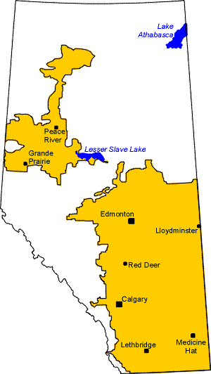
Figure 1. The yellow areas are known as the Agricultural or White Area of the Province.
Spatial manipulation and analysis of the AGRASID data has been made possible in a Geographic Information System GIS environment by offering the AGRASID 3.0 in two industry standard spatial data formats:
- Arcview 3.x shape files (*.dbf, *.shx and *.shp), and
- ESRI arc export interchange files (E00 uncompressed).
Descriptions of the GIS and Database Files
GIS coverage files�
The GIS coverage contains the soil polygons with a soil polygon number identifier, township, range, meridian, area and perimeter information. Each GIS coverage is geo-referenced to the 1:20 000 provincial digital base map with a projection of 10 degree Transverse Mercator (10TM, central meridian: -115 degrees W, scale factor: 0.9992 and a NAD 83 datum).� Data in geographic (latitude, longitude) format is also available. Complete coverage for the agricultural regions of the province (as they existed in the mid 1990's) is included. The provincial coverage is also partitioned into smaller files for users who may not wish to copy the complete coverage onto their system.
Soil landscape attribute files
The Soil Landscape Attribute AG30 file contain data that describe the soils (series level) and landscape features (ie. hummocky) in the form of a map symbol for each polygon. The file also contains data captured from the National Ecological Framework that includes codes for Ecoregions, Ecodistricts, and Land Systems.
Basic soil evidence files
The Basic Soil Evidence AG30MAS file contain the attribute data about the soil (or soils) identified within each polygon. The number of soils described for a polygon may vary from one to seven different soils.
Soil names file
The Soil Names file AG30SNF contains information on all the soil names currently recognized in Alberta. The Soil Names File is current to the date of publishing of AGRASID.� The file is updated and revised as required.
Soil layer file
The Soil Layer file AG30SLF contains information on the chemical and physical properties for each soil name listed in the Soil Names File. Within the Soil Layer File, the horizons (or layers) of each soil series are identified as individual records. The fields defined in this file are the minimum data set necessary for interpreting soils for agronomic purposes.
Land systems file
The Land Systems file AG30LSLG contains attribute data that describes the representative soils, landscapes and the amount of wet and/or saline areas.� Up to three major soils, two minor soils and two landscapes are identified for each polygon.� Land systems are assigned to the Ecozones, Ecoregions and Ecodistricts as defined in the National Ecological Framework for Canada.� Ecodistricts are the smallest unit of this national framework and Land Systems are subdivisions of Ecodistricts.
Soil Landscapes
The soil landscape information described in AGRASID is intended to be represented at a scale of 1:100 000.� The soils and landscapes were recognized and separated by differences in surface form, surficial geological materials, drainage and soil patterns. The recorded information was processed within a custom program using an automated set of rules to generate a Soil Landscape Model symbol for each polygon.
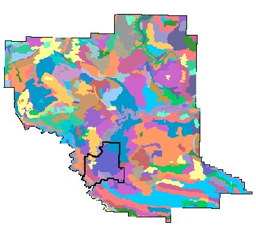
Figure 2. An example of Soil Landscape polygons in the County of Lethbridge
Land Systems
Area of country in which there is a recurring pattern of soils, vegetation and topography.� They are described by morphology such as: Plain, Upland, Lowland, Valley or Wetland.� Soil and landscape data from AGRASID ‘rolled up’ to produce a general description for the area.
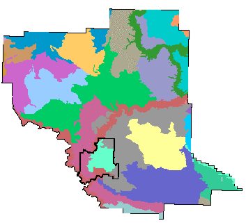
Figure 3. An example of Land System polygons in the County of Lethbridge
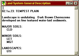
Figure 4. An example of the kind of information available in the Land System Legend file AG30LSLG
|
|