| | Why classify land? | Standards for classification | Irrigation factors | Soil classification | Topography classification | Land classes | Requesting land classification
Land classification for irrigation in Alberta is a multi-faceted process:
- begins with the systematic examination, description, appraisal, and grouping of land
- grouping is based on the physical and chemical characteristics affecting its suitability for sustained production under irrigated agriculture
- land selection for irrigation also involves predicting how land will respond after development and the application of irrigation water
Why Classify Land?
Land classification is done to determine the extent and degree of suitability of land for irrigation. Land units are grouped into one of seven interpretive classes depending on the relative capability for sustained production under irrigation.
This classification also provides an inventory of land characteristics, identifies potential problems that may occur with irrigation and makes recommendations for appropriate management under irrigation. Land classification is also used in planning large-scale irrigation development projects.
Standards for Classification
Alberta is the only province in Canada that has a mandatory requirement for land classification for irrigation within irrigation districts. The 1968 Irrigation Act caused a set of standards to be established in 1969 for land classification for irrigation. In 1978, land classification was made a mandatory requirement before any new land could be added to the assessment roll of irrigation districts.
The shift from early gravity irrigation to sprinkler irrigation, combined with ongoing research findings, resulted in the 1969 standards being revised in 1983. The 1983 standards were revised again in July 1990 to allow irrigation of land that was undergoing reclamation following the implementation of a reclamation measure such as installation of drainage or canal lining.
In November 1998, the standards were revised to allow the irrigation of some Solonetzic soils as a result of research and monitoring studies completed in Alberta. The standards were amended again in September 1999 to clarify the rating for soils over shallow bedrock and soils over shallow gravel. New standards were printed after the Irrigation Districts Act replaced the Irrigation Act in May 2000.
The standards for the classification of land for irrigation have been used to coordinate and oversee all land classification for irrigation activities in Alberta. The standards outline the minimum requirements with which any land must comply to be classified as "irrigable," so they can be supplied with water.
The standards are used for the classification of lands for the formation of a new district or for the reclassification of lands within a district. Land classification for irrigation is also a required input to the agricultural feasibility report needed for the licensing of irrigation projects outside irrigation districts, according to the Water Act (1999). It is also required when developing municipal and some industrial wastewater irrigation projects under the Environmental Protection and Enhancement Act (1992).
Irrigation Factors
Land classification for irrigation means considering several factors:
- permanent factors
- changeable factors
- predicted response to irrigation
Factors such as soil depth, parent material, texture, and adverse topography are considered permanent land features. Changeable factors include fertility, drainage, groundwater, salt content, soil pH, and erodibility. Soil structure may be modified by physical and chemical processes. Relocation and chemical changes in soluble salts may occur as a result of irrigation. Micro-relief and characteristics of the soil profile can be altered by land forming, stone and brush removal, drainage, subsidence, or by increased erosion due to irrigation. Soil and topography ratings are determined separately and combined into a land class that reflects the suitability of land for irrigation farming.
If land is to be irrigated, it has to be permanently productive under the changes anticipated with irrigation. As a result, the land classes must reflect the predicted land-water-crop interaction expected to predominate after irrigation development. This principle of prediction recognizes that irrigation shifts the natural balance, established over time, between water, land, vegetation, fauna, and humans.
Soil Classification
Soils reflect their environment. Each soil has developed its own physical, chemical and morphological features (physical forms) as a result of the interaction of topography, climate, vegetation, and biological activity on the parent geological material over time. Soil environment changes under irrigation. Because the soil is a dynamic body, it responds to this change.
Certain soil conditions are needed for profitable, diversified crop production under sustained irrigation:
- adequate moisture holding capacity for the proposed methods of irrigation and cropping pattern
- adequate internal soil drainage through the root zone to permit proper aeration, replenishment of soil-water reservoirs, and leaching of soluble salts
- adequate infiltration rates to facilitate replenishment of moisture lost through evapo-transpiration, to minimize erosion and to prevent excessive deep percolation under the proposed irrigation method
- sufficient depth of suitable material to allow necessary root development and to provide adequate storage of moisture and plant nutrients
- suitable texture, structure, and consistency to permit necessary and timely field operations
- absence of injurious amounts of salinity, sodicity or toxic elements
A soil rating (S) is calculated from the permanent soil characteristics: soil profile, geological deposit and surface texture. The parent geological material, along with topography, vegetation, biological activity, climate, and time, has given the soil its characteristics or soil profile. Geological deposit consists of major characteristics such as the depth to an impermeable barrier, uniformity of the deposit, texture, and drainability. Soil texture affects the infiltration rate, water holding capacity and soil erodibility.
The changeable factors of drainage, salinity and sodicity of the root zone are used to modify the basic soil rating. Soils are grouped into one of four soil (S) irrigation capability categories:
Category 1: Excellent irrigation capability.
Category 2: Good irrigation capability.
Category 3: Fair irrigation capability.
Category 4: Non-irrigable.
Soils in the first three categories are suitable for irrigation. Soils in category four are non-irrigable and would not be considered for irrigation.
Medium-textured Chernozemic soils, developed in uniform deposits, are the most desirable for irrigation. The degree to which soils differ from this optimum state determines their suitability for sustained irrigated agriculture.
Most of the irrigated soils in southern Alberta are located in the Brown and Dark Brown soil zones with some in the Black soil zone. The predominant parent material is glacial till, usually overlain by about a metre, more or less, of wind- or water-modified materials.
Topography Classification
Topography classification involves grouping land into categories according to surface features:
- relief
- size and shape of fields
- earth moving requirement
- stoniness
- brush/tree cover
- surface drainage requirements
Topographic features are extremely important in irrigated agriculture since they may determine the choice of irrigation method. These features can also affect labor requirements, irrigation efficiency, drainage, erosion, range of possible crops, size and shape of fields, and the cost of land development. Operational expenses also increase with rough surface features, small fields, stoniness or brush/tree cover, and greater surface drainage requirements. These factors are reflected in four topography (T) categories.
Topography (T) categories
Category 1: includes all land suitable to develop for gravity or any other method of irrigation.
Category 2: identifies land suitable for conventional sprinkler irrigation systems in common use in Alberta.
Category 3: identifies extremely rolling or hummocky terrain that is only irrigable with specialized sprinkler systems designed to operate on rough ground to minimize runoff and water erosion and to prevent prolonged surface ponding. This category also includes small, irregularly shaped fields that are irrigable with modified conventional sprinkler systems.
Category 4: land in this category is not suitable for irrigation development due to one or a combination of factors, such as: steep slopes, hummocky relief, stoniness, brush/tree cover, small or irregularly shaped fields, sloughs, wetlands, and rough-broken topography.
Land Classes
The land class indicates the general capability of land for irrigation use in its present state. Land classes are based on the rating and assessment of both soil and topographic features that affect the suitability of land for irrigation. The land class represents a grouping of soil and topography categories that have the same relative degree of limitations or hazards for irrigation use. Land within a land class is alike, or nearly alike, in its potential to be developed and in its response to a similar level of management.
Seven land classes are recognized in the land classification system for irrigation in Alberta. The limitations or hazards become progressively greater from Class 1 to Class 6. Land in Class 1 to Class 4 is suitable for irrigation. Class 5R is temporarily irrigable, undergoing reclamation. Class 5 is a non-irrigable provisional class. Class 6 identifies the non-irrigable land.
Class 1 - Irrigable: Land in this class is excellent for irrigated agriculture with no significant limitations. Class 1 land is capable of producing a sustained and relatively high yield of a wide range of climatically adapted crops. The soils are of a medium texture, well drained and hold adequate available moisture. There are no harmful accumulations of soluble salts. Class 1 land is level to nearly level. This class is suitable for irrigation by both gravity and sprinkler methods.
Class 2 - Irrigable: Land in this class is good irrigation land with moderate limitations. A narrower range of crops or slightly more input to development and management may be required for Class 2 land than for Class 1. The limitations of Class 2 land make it less acceptable than those of Class 1; however, these limitations can be maintained or possibly improved with proper management.
The soils in this class may have low hydraulic conductivity due to fine texture or adverse structure. The available water holding capacity may be lower as reflected by the coarser texture or limited soil depth. Salinity levels may be low to moderate. Drainability may be somewhat restricted. Class 2 land may be level to gently sloping or undulating to hummocky. Land in this class is suitable for irrigation by gravity and sprinkler methods or by sprinkler methods only.
Class 3 - Irrigable: Land in this class is fair for irrigation. Limitations of this land under irrigation are moderately severe. The deficiencies may be due to either one single serious factor or a combination of several limitations in soil and/or topographic features.
The soils may be inferior because of excess salinity, sodicity, very low hydraulic conductivity or low water holding capacity. Subsurface drainability or surface drainage may be restricted. As a result, the range of crops that could be grown may be restricted. Greater management input, such as light, frequent irrigations or more intensive soil conservation and improvement practices, may be required than for Class 2 land. Class 3 land may be level to hummocky. Land in this class is suitable for irrigation by gravity and sprinkler methods or by sprinkler methods only.
Class 4 - Irrigable (restricted): Land in this class has severe limitations for irrigation and requires special crop, soil and water management practices. Limitations of Class 4 land may include moderate to strong slopes or small irregularly shaped fields. Class 4 land is suitable for irrigation with a special irrigation system designed to minimize runoff and water erosion and to prevent prolonged surface ponding.
Class 5R - Temporarily irrigable (undergoing reclamation): Class 5R land is undergoing reclamation after the implementation of an appropriate improvement, such as drainage or canal lining.
Class 5R land shall be added to the assessment roll as acres subject to a terminable agreement, for the purpose of promoting reclamation. Class 5R land shall be reviewed after the land has undergone reclamation for five irrigation seasons, after which the land shall be upgraded to an irrigable class (Class 1, 2, 3, or 4) if it meets the requirements, or remain as Class 5R for an additional 5 years. If significant improvement has not been achieved within a 10-year period to upgrade the land to an irrigable class, then the land shall be rated Land Class 6, non-irrigable, and the terminable water agreement shall be discontinued. Land in this class is suitable for irrigation by gravity and sprinkler methods or by sprinkler methods only.
Class 5 - Non-irrigable (pending): Land in this class is considered not suitable for irrigation under existing conditions, but has sufficient potential to warrant segregation for additional investigation or improvement. The limitations of Class 5 may include one or more of the following: poor drainability, a high water table, very poor soil structure, and excess salinity and/or sodicity.
Two subclasses are recognized in LAND CLASS 5:
- Class 5 - Non-irrigable, pending a more detailed investigation. Limitations are such that a more detailed soil, drainability or land development feasibility study may be required.
- Class 5 - Non-irrigable, pending the implementation of an improvement. An improvement such as canal lining or improved surface or subsurface drainage may be required to upgrade this land to an irrigable class or Class 5R.
Class 5 is a tentative land class - changed to either an irrigable class or rated Class 6, non-irrigable, upon completion of the detailed study or implementation of an improvement. The topography of this land may range from level to moderately sloping, simple or complex slopes.
Class 6 - Non-irrigable: This class may consist of steep, rough-broken or badly eroded land or land having soils of very poor structure, very coarse texture, excess salinity and/or sodicity, poor drainage, shallow soils over gravel or bedrock, or other deficiencies not feasible to improve. Class 6 land may also include Land Classes 1 to 5, which cannot be separated out due to small size, the intensity of the investigation or the purpose of the project.
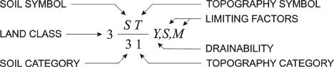
Land Class 1 has no limiting factors. Other land classes have their respective limitations identified on land classification maps by using different code letters, each identifying a particular limitation.
The limiting factors "S" (salinity) and "M" (low moisture holding capacity) are the reasons the soils are given a soil category 3 rating, in the following land class symbol. The drainability "Y" shows that the soils are slowly permeable in the 1- to 2-metre zone. The topography rating is category 1, suitable for gravity or sprinkler irrigation. The combination of soil category 3 and topography category 1 results in a land Class 3 rating.
Land Class Symbol:
Requesting Land Classification
Land classification for irrigation is now completed by a professional consulting agrologist. A list of land classification consultants is maintained by the Irrigation Management Section of Alberta Agriculture and Forestry.
Revised by:
Ravinder Pannu
Irrigation Management Section
Irrigation and Farm Water Branch
Alberta Agriculture and Forestry
For more information
Alberta-Ag Info Centre
Call toll free 310-FARM (3276)
Source: Agdex 560-3. Revised May 2016. |
|