| | Introduction | Soil classification | Topography classification | Land classification | Appendix A
Introduction
The classification of land for irrigation is an assessment of the physical and chemical factors of soil and topography that affect irrigation potential. Land selected for irrigation should remain permanently productive under the change in the physical and chemical regime anticipated after the application of water. The conservation of land and water must be a prime objective of any land classification standards for irrigation.Wherever the word “standards” appears in this document, it refers to the “Standards for the Classification of Land for Irrigation in the Province of Alberta.”
It was in consideration of these principles that Irrigation Council caused to be prepared the first set of “Standards for the Classification of Land for Irrigation in the Province of Alberta”. The standards were formally approved on November 6, 1969, as per Section 113(1) of the Irrigation Act in effect at that time, which stated:
"The (Irrigation) Council shall cause to be prepared a set of standards for each district setting out the minimum requirements, taking into account all factors that it considers relevant, with which any land must comply in order to be suitable to receive water for irrigation."
In the late 1970s, Irrigation Council appointed a committee to review the 1969 standards as to their appropriateness under more recent irrigation practices, and in consideration of the experience gained in irrigating land classified under the 1969 standards. The committee was asked to make such recommendations, as they deemed necessary with regard to updating the standards.
The committee reviewed the 1969 standards in consultation with the Land Classification Branch of Alberta Agriculture, and revised standards were approved by Irrigation Council on October 12, 1983. In addition, Irrigation Council approved the use of a Level II intensity of investigation, as described in Appendix A, for classifying land for irrigation purposes.
The 1983 standards differed from the 1969 standards in that land classes, soil categories and topographic categories were updated to be more meaningful and to reflect the relative capability of land for irrigation. The minimum requirement with which any land must comply to be considered suitable to receive water for irrigation was Land Class 4. On July 12, 1990, Irrigation Council adopted a further change allowing acres rated Land Class 5R to be added to the assessment roll as “other acres” which are the subject of a terminable water agreement for the purpose of promoting reclamation. The Class 5R land shall be reclassified after 5 irrigation seasons and either upgraded to an irrigable class, rated nonirrigable, or remain as Class 5R for a further 5 years. If sufficient improvement has not been seen in 5 or 10 years, the land shall be rated Land Class 6 and the terminable water agreement canceled. Irrigation Council approved a further change to the standards on November 12, 1998, to allow irrigation of some Solonetzic soils as a result of research and monitoring studies completed in Alberta. The standards were amended again on September 8, 1999, to clarify the rating for soils over shallow bedrock and soils over shallow gravel.
The Irrigation Districts Act replaced the Irrigation Act on May 1, 2000. Section 94 of the Irrigation Districts Act states, in part:
“The Minister must establish by regulation
(a) land classification standards to be used by each district to classify land according to its suitability for irrigation purposes,...”
Section 4 of the Irrigation General Regulation states:
(1) For the purposes of section 94(a) of the Act, the district must use the latest edition of “Standards for the Classification of Land for Irrigation in the Province of Alberta” approved by the Council and published by the Department.
(2) Notwithstanding subsection (1), land classifications that were made in accordance with previous editions of the standards referred to in that subsection may, with the Council’s approval, continue to be used for land assessment purposes.
In accordance with subsection (2) above, on September 11, 2003, Irrigation Council approved, for irrigation district land assessment purposes, the use of land classification reports prepared according to the 1983 or subsequent “Standards for the Classification of Land for Irrigation in the Province of Alberta”. Section 5 of the Irrigation General Regulation outlines the land assessment criteria, which must be met when revising the assessment roll of an irrigation district.
The standards outline the minimum requirements with which any land must comply in order to be classified as “irrigable”, and are the standards to be used for the classification of lands for the formation of a new district, or for the reclassification of lands within a district. These standards apply to all irrigation districts in Alberta. Alberta Agriculture, Food and Rural Development, Irrigation Branch, has prepared a procedures manual for use with these standards.
Standards for the Classification of Land for Irrigation in the Province of Alberta - Downloadable PDF - 515K
Procedures Manual for the Classification of Land for Irrigation in Alberta - Downloadable PDF - 1500K
Soil Classification
Soil classification involves the grouping of soil into categories according to permanent characteristics - texture, structure, profile development, porosity, bulk density, proximity of lime to the surface, infiltration rate, hydraulic conductivity, water holding capacity, uniformity and depth of geological deposit, and depth to bedrock; and changeable characteristics - fertility, soil drainage, depth to groundwater, salinity, sodicity, soil reaction, and erodibility. Drainability is assessed as part of the soil rating.
Soil categories
Soils are grouped into one of four categories:
| Soil Category | Final Soil Rating Index |
| 1 - Excellent irrigation capability | 72 - 100 |
| 2 - Good irrigation capability | 46 - 71 |
| 3 - Fair irrigation capability | 26 - 45 |
| 4 - Nonirrigable | ��� < 25 |
The first three categories are considered suitable for irrigated agriculture whereas the fourth category is considered nonirrigable. The final soil rating is determined by calculating a Basic Soil Rating (B.S.R.) from the permanent characteristics - soil profile (P), geological deposit (G), and texture (T) and by modifying the B.S.R. by considering the influence of changeable characteristics - soil drainage, salinity, and sodicity.
Basic soil rating
The Basic Soil Rating (B.S.R.) is calculated as follows:
B.S.R. = P x G x T, expressed as an index
Example: Calculate the B.S.R. of an Orthic Brown Chernozemic soil that has formed in a veneer of moderately coarse-textured (i.e. FSL) fluvial or eolian sediments overlying moderately fine-textured (i.e. CL) morainal sediments. The depths to the "Cca" horizon and the glacial till are 40 cm and 65 cm, respectively.
| P = 100 | The Orthic Chernozemic soil profile has a depth greater than 30 cm to "Cca" horizon (Table 1.1). |
| G = 70 | This is a variable geological deposit, characterized by a textural change of two classes between the fluvial-eolian veneer and the underlying, morainal sediments (Table 1.2). |
| T = 90 | The texture class of the veneer is fine sandy loam (Table 1.3). |

This is a good irrigation soil, since the B.S.R. of 63 places it within soil category 2.
The ratings for the P, G, and T factors are for the average or normal situation. Slight adjustments can be made to any factor rating when soils have characteristics that vary significantly from the average or normal.
Soil profile rating
Determination of the soil (S) rating begins with assignment of a soil profile rating. These ratings are assigned from Table 1.1.
Table 1.1 Ratings for the soil profile factor.(1,2)
| Soil Order, Great Group or Subgroup, and Characteristics | Rating Index |
| Chernozemic Soils |
| Orthic Chernozemic, > 30 cm to Cca | 100 |
| Orthic Chernozemic, 15 to 30 cm to Cca | 90 |
| Orthic Chernozemic, < 15 cm to Cca | 80 |
| Calcareous Chernozemic | 80 |
| Rego Chernozemic | 70 |
| Rego and Calcareous Chernozemic, minimal or no structure, coarse | 70 |
| Eluviated Chernozemic, > 15 cm to Bt | 90 |
| Eluviated Chernozemic, < 15 cm to Bt | 80 |
| Solonetzic Chernozemic, > 15 cm to Blocky Btnj | 90 |
| Solonetzic Chernozemic, < 15 cm to Blocky Btnj | 80 |
| Gleyed Chernozemic(3) (average situation) | 70 |
| Solonetzic Soils(4) |
| Solonetz, very hard and/or massive Bn | 30 |
| Alkaline Solonetz | 20 |
| Solodized Solonetz, > 15 cm to Bnt | 80 |
| Solodized Solonetz, < 15 cm to Bnt | 70 |
| Solod, > 15 cm to Bnt | 90 |
| Solod, < 15 cm to Bnt | 80 |
| Gleyed(3) | 30 |
| Regosolic Soils |
| Regosol | 60 |
| Cumulic Regosol | 60 |
| Humic Regosol | 70 |
| Gleyed(3) | 50 |
| Gleysolic Soils(5) |
| Orthic Humic Gleysol | 70 |
| Rego Humic Gleysol | 60 |
| Orthic Gleysol | 60 |
| Rego Gleysol | 50 |
| Orthic Luvic Gleysol | 50 |
| Humic Luvic Gleysol | 60 |
(1) Infiltration rate and hydraulic conductivity measurements can be undertaken to supplement evidence of restricted vertical permeability as indicated by morphological features such as gleying and mottling, adverse structure, layering or presence of a hardpan or fine-textured layers. These measurements may be used as a guide in rating soils for irrigation, although high or low infiltration rates or hydraulic conductivity will generally be associated with other undesirable soil properties already evaluated in the soil profile rating.
(2) Depending on the severity of erosion, eroded soils could be rated either as a Rego Chernozemic or Regosol.
(3) Gleyed soils - Because drainage limitations are variable and can be corrected, adjustments can be made to the rating, depending on the severity of the limitation, and ease with which it can be corrected. Drainage is considered a changeable soil characteristic.
(4) Solonetzic soils - Soil salinity and sodicity are taken into account in section 1.3, Modified Soil Rating, using the salinity and sodicity levels of Table 1.4. The depth to a water table (Table 1.6) and the salinity profile (Table 1.4, note 4) are also considered. This could result in an irrigable rating for Solonetzic soils having an SAR less than 12 in the B horizon, provided all other criteria for salinity and sodicity, depth to a water table and net downward water movement are met.
(5) Gleysolic soils - All are nonirrigable in their natural state. However, if proper drainage is provided, the permanent soil characteristics resulting from the poor drainage must be rated lower than those in the well drained counterpart on similar parent material. Gleysolic soils may crust and bake when drained, making seed bed preparation difficult.
Geological deposit rating
The parent geological material, in association with topography, biological activity, climate and time has given a soil its characteristics. The depth to an impermeable barrier, uniformity of the deposit and drainability are the major characteristics to be considered. Ratings for geological deposits are presented in Table 1.2.
Table 1.2 Ratings for the geological deposit.
| Geological Deposit(1, 2, 3) | Rating Index |
| Uniform wind and/or water lain (excluding outwash), gradual texture change(4) | 100 |
| Fairly uniform water lain, textural change of 1 class within 1 m | 80 |
| Permeable tills (those with Chernozemic profile development) | 90 |
| Variable deposits |
| ���� (1) Abrupt material change between 50 and 100 cm of surface |
| ������������ (a) Both upper and lower materials of similar texture | 90 |
| ������������ (b) Textural change of 1 class between overlay and lower material | 80 |
| ������������ (c) Textural change of 2 classes between overlay and lower material | 70 |
| ������������ (d) Textural change of 3 classes between overlay and lower material | 60 |
| ���� (2) Abrupt material change within 50 cm of surface. Reduce appropriate rating by 10 units |
| Outwash and variable coarse materials(5) | 40 |
| Impermeable sedimentary bedrock within 2 m of the surface(6) | 20 |
(1) The water content of fine-textured soil overlying a coarse layer is greater than that in non-layered soil. The water holding capacity of very sandy soils may be inadequate for surface methods of irrigation.
(2) With saline parent material (ECe > 8 dS/m and/or SAR > 12) present below 1 m, the material rating is reduced by 10 units (i.e. till rated at 90 is reduced to 80).
(3) Hydraulic conductivity less than 1 mm/h may present difficulties under irrigation and require careful irrigation management.
(4) For rating purposes, use seven textural classes as follows: (Gr, S) - very coarse; (LS) - coarse; (SL, FSL) - moderately coarse; (L, VFSL, SiL) - medium; (CL, SCL, SiCL) - moderately fine; (SiC, C, SC) - fine; (HC) - very fine.
(5) Variable coarse materials include coarse-textured ice contact deposits, which are often quite variable throughout. Soils with less than 50 cm to gravelly outwash or variable coarse material are rated nonirrigable (soil category 4).
(6) Soil profiles with impermeable sedimentary bedrock within 2 m of the surface are rated nonirrigable (soil category 4). Soil profiles with impermeable sedimentary bedrock between 2 and 3 m of the surface would be placed in soil category 3 or 4, depending on the physical and chemical characteristics of the overburden. Total available moisture holding capacity of the 2- or 3-m profile must be greater than 200 mm for an irrigable rating to be applied.
Soil texture rating
Medium-textured Chernozemic soils, developed in uniform deposits are most desirable for irrigation. The degree to which soil textures deviate from this optimum determines their suitability for sustained irrigated agriculture. Coarse-textured soils are limited by low available moisture holding capacity. An available moisture holding capacity less than 80 mm/m identifies a severe limitation to irrigation suitability and management. Fine-textured soils are less suitable due to slow infiltration and low hydraulic conductivity. Soils having infiltration rates or hydraulic conductivity less than 1 mm/h are generally considered nonirrigable. Water application rates under sprinkler irrigation can be controlled to partially compensate for low infiltration rates and low hydraulic conductivity. Ratings for soil texture are presented in Table 1.3.
Table 1.3 Ratings for soil texture.
| Texture Class | Rating Index |
| With normal textural gradients: |
| ����� Loam, silt loam, very fine sandy loam | 100 |
| ����� Fine sandy loam | 90 |
| ����� Clay loam, silty clay loam, sandy clay loam | 80 |
| ����� Sandy loam | 70 |
| ����� Coarse sandy loam, silty clay, sandy clay | 60 |
| ����� Loamy sand, clay | 50 |
| ����� Loamy coarse sand, heavy clay | 40 |
| ����� Sand | 30 |
| ����� Gravel | 20 |
Modified soil rating
The Basic Soil Rating (B.S.R.) is modified by the salinity and sodicity in the soil profile and by soil drainage.
Soil salinity and sodicity
Soil salinity and sodicity levels are determined by using Table 1.4.
Table 1.4 Soil salinity and sodicity levels.(1,2)
 | Salinity (ECe, dS/m)(3,4) | � | Sodicity (SAR) |
� | 0-0.5 m(5) | 0.5-1 m | 1-2 m(6) | � | 0-1 m | 1-2 m(6) |
Salinity-Sodicity Level | "a" | "b" | "e" | � | "n" | "m" |
1
2
3
4
5
6 | < 2
< 4
< 6
< 8
<12
>12 | < 4
< 8
<12
<16
<20
>20 | < 8
<12
<16
<20
<24
>24 | � | < 6
< 9
<12
<15
<18
>18 | < 6
< 9
<12
<15
<18
>18 |
(1) The degree of salinity and/or sodicity may vary widely within short distances and there may be no clear indication of the area occupied by each salinity/sodicity level. Unless a very detailed mapping and sampling program is carried out, it is impossible to estimate the acreage occupied by each salinity level.
(2) It is very difficult to accurately predict the amount and extent of salinity that may develop after irrigation water is applied, but some general estimate can be made. Salinity and sodicity levels may improve under irrigation provided internal drainage of the soil profile is favorable.
(3) Soluble salt concentration may change rapidly throughout the growing season when water application and evaporation are at their maximum. In irrigated surface soils, EC readings are generally higher in the spring as compared to the fall. The time of sampling is significant when soluble salt content of the surface soil is being investigated.
(4) Salinity along a profile is a useful indicator of net downward movement of water and salts. Regular soil salinity profiles, where salinity is increasing with depth, indicate net downward water movement. Inverted salinity profiles, where salinity is higher near the surface and decreases with depth, indicate a possible discharge gradient, and possibly a high water table where irrigation could result in an increase in soil salinity.
(5) This usually refers to the solum (A and B horizons), but also includes the C horizon if present within the upper root zone.
(6) High ECe and SAR levels at lower depths present a potential salinization hazard under poor irrigation practices, but are primarily a soil and water management consideration. Salinity ("e" factor) and sodicity ("m" factor) at lower depth are evaluated as part of the Geological Deposit under the Basic Soil Rating. Parent material is downgraded if the ECe is greater than 8 dS m-1 and/or the SAR is greater than 12.
The salinity and sodicity of the upper root zone has a profound influence on soil productivity. The salinity (a and b) and sodicity (n) of the root zone are used to modify the B.S.R. (Table 1.5). Salinity (e) and sodicity (m) below the root zone are evaluated with the Geological Deposit.
Table 1.5 Salinity-sodicity modifier.
Salinity-Sodicity Levels
("a", "b" and/or "n") | Rating Index |
1
2
3
4 - 6 | B.S.R. x 100
B.S.R. x 90
B.S.R. x 70
Soil Category 4 |
Soil salinity and sodicity levels in each category are useful guidelines in assessing the severity of soil chemical restrictions, however, the chemistry of a given soil unit must finally be assessed in light of the total hydrogeological and pedological environment.
Soil drainage
Soil drainage may also modify the Basic Soil Rating (Table 1.6).
Table 1.6 Soil drainage modifier.
Soil Drainage | Rating Index |
Well to imperfectly drained
Poorly drained(1,2) | B.S.R. x 100
Soil Category 4 |
(1) Gleysolic soils and soils restricted by the presence of shallow groundwater (less than 1 m).
(2) Solonetzic soils, where the depth to groundwater is less than 3 m under dryland conditions or less than 2 m under irrigation.
Drainability
Table 1.7 Drainability is a description feature inferred from the most permeable layer in the 1- to 2-m zone.
Map Symbol | Drainability | Hydraulic Conductivity (mm/ h) | Texture |
X | Moderately to rapidly permeable | > 10 | Gr, S, LS, SL, FSL, L, SiL |
Y | Slowly permeable | 1 - 10 | SCL, CL, SiCL, SiC, C, SC |
Z | Relatively impermeable | < 1 | Heavy clay and bedrock |
The final soil rating
Soils are grouped into one of four categories based on a soil rating calculated from the characteristics discussed in Section 1.0.
| Soil Category | Final Soil Rating Index |
| 1 - Excellent irrigation capability | 72 - 100 |
| 2 - Good irrigation capability | 46 - 71 |
| 3 - Fair irrigation capability | 26 - 45 |
| 4 - Nonirrigable | ���� < 25 |
The first three categories are suitable for irrigated agriculture, whereas the fourth category is nonirrigable.
Soil complexes
Soil units which are mapped as complexes having more than approximately 30% (� 10%) nonirrigable soils that are solonetzic, saline, sodic, gleyed, or gleysolic will be rated nonirrigable.
Soil units mapped as complexes having minor occurrence (< 20%) of nonirrigable soils, or as complexes of irrigable soils, will be rated by multiplying the proportion of each soil type by its respective soil rating. Rating of nonirrigable portions of a complex should not be added to irrigable portions to determine the final soil category.
Proportion of Unit (%) | x | B.S.R. Index | x | Modifier(s) Index | = | Partial Soil Rating Index |
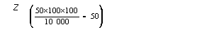
50 | x | 100 | x | 100 | = | 50Z |
30 | x | 90 | x | 100 | = | 27 |
20 | x | 20 | x | 90 | = (4) | ------ |
Final Soil Rating
Soil Category = 1 | 77 |
 | The final category assigned to a given soil unit must satisfy the best judgement of the land classifier. |
Topography Classification
Topography classification involves the grouping of land into categories according to surface features, such as: relief, size and shape of fields, earth-moving requirements, stoniness, brush/tree cover, and surface drainage requirements.
Topographic features determine the choice of irrigation method, affect labor requirements, irrigation efficiency, drainage, erosion, range of possible crops, size and shape of fields, and the cost of land development.
Topography categories
The four topography (T) categories are:
Category 1: This category includes all land suitable to develop for gravity or any other method of irrigation.
Category 2: This category identifies land that is suitable for conventional sprinkler irrigation systems in common use in Alberta.
Category 3: This category identifies extremely rolling or hummocky terrain that is only irrigable with specialized sprinkler systems designed to operate on rough ground, to minimize runoff and water erosion, and to prevent prolonged surface ponding. This category also includes small, irregularly shaped fields that are irrigable with modified conventional sprinkler systems.
Category 4: Land in this category is not suitable for irrigation development due to one or a combination of factors, such as: steep slopes, hummocky relief, stoniness, brush/tree cover, small or irregularly shaped fields, sloughs, wetlands, and rough-broken topography.
Topography rating
The limiting factors evaluated to arrive at a topography rating are:
- Earth-moving requirement.
- Field size, shape, and length of irrigation run.
- Water distribution, slope, and erosion control.
- Stoniness and brush/tree cover.
- Surface drainage.
Table 2.1 may be used to obtain the final topography category.
Table 2.1 Specifications for the topography rating.
| Topography Categories |
Map Symbol | Limiting Factors | 1-Gravity | 2-Sprinkler | 3-Sprinkler | 4-Nonirrigable |
U | Earth moving
(m3/ac) | < 400 | > 400 | > 400 | |
J | Length of run (m) | > 110 | not rated | not rated |
| Field size (ac) | > 5 | > 20 | > 20 rough terrain
5-20 small field |
| Field shape(1,2) | Regular | Regular | Irregular |
G | Maximum downfield slope (%) | 2 | 9 simple or complex | 20 complex
30 simple |
| Minimum downfield slope (%) | 0.2 | not rated | not rated |
P | Stoniness
(% of surface covered) | < 15 | < 15 | < 15 |
B | brush/tree cover
(% of surface covered) | < 15 | < 15 | < 15 |
F | Surface drainage,
depth of cut (m)(3) | < 1.2 | > 1.2 | > 1.2 |
(1) Regular refers to rectangular, square or circular shape.
(2) Topography category 2 may have irregular shape if the field is > 20 acres.
(3) Excess depth of cut for an open drain will not constitute a nonirrigable limitation.
Land Classification
Land classes
The land class indicates the general capability of land for irrigation use in its present state. Land classes are based upon the rating and assessment of soil and topographic features that affect the suitability of land for irrigation. The land class represents a grouping of sub-classes that have the same relative degree of limitations or hazards for irrigation use. Land within a land capability class is alike, or nearly alike, in its potential to be developed and in its response to a similar level of management. Seven land classes are recognized in the land classification system for irrigation in Alberta. The limitations or hazards become progressively greater from Class 1 to Class 6. Land in Class 1 to Class 4 is suitable for irrigation. Class 5R is temporarily irrigable, undergoing reclamation. Class 5 is a nonirrigable provisional class. Class 6 identifies the nonirrigable land.
Class 1 - irrigable: Land in this class is excellent for irrigated agriculture with no significant limitations. Class 1 land is capable of producing a sustained and a relatively high yield of a wide range of climatically adapted crops. The soils are of a medium texture, well drained, and hold adequate available moisture. Harmful accumulations of soluble salts are absent. Class 1 land is level to nearly level. This class is suitable for irrigation by gravity and sprinkler methods.
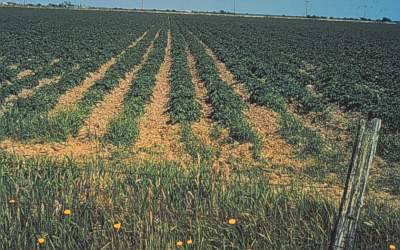
Figure 1. Class 1 land suitable for gravity or sprinkler irrigation for a variety of crops.
Class 2 - irrigable: Land in this class is good irrigation land with moderate limitations. A narrower range of crops or slightly more input to development and management may be required for Class 2 land than for Class 1. The limitations of Class 2 land are less acceptable than those of Class 1. They can be maintained or possibly improved with proper management. The soils in this class may have low hydraulic conductivity due to fine texture or adverse structure. The available water holding capacity may be lower as reflected by the coarser texture or limited soil depth. Salinity levels may be low to moderate. Drainability may be somewhat restricted. Class 2 land may be level to gently sloping or undulating to hummocky. Land in this class is suitable for irrigation by gravity and sprinkler methods or by sprinkler methods only.
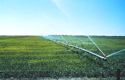
Figure 2. Example of Class 2 land suitable for sprinkler irrigation only.
Class 3 - irrigable: Land in this class is fair for irrigation. Limitations of this land under irrigation are moderately severe. The deficiencies may be due to either a serious single factor or a combination of several limitations in soil and/or topographic features. The soils may be inferior because of excess salinity, sodicity, very low hydraulic conductivity, or low water holding capacity. Subsurface drainability or surface drainage may be restricted. The range of crops that could consequently be grown may be restricted. A greater management input, such as light, frequent irrigations or more intensive soil conservation and improvement practices, may be required than for Class 2 land. Class 3 land may be level to hummocky. Land in this class is suitable for. irrigation by gravity and sprinkler methods or by sprinkler methods only.
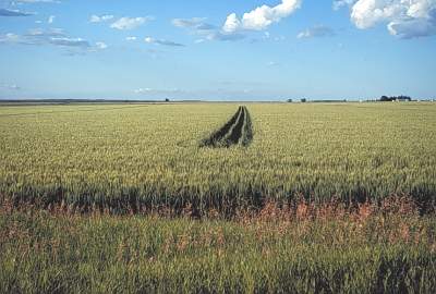
Figure 3. Class 3 land due to category 3 soils. Topography is suitable for gravity or sprinkler irrigation.
Class 4 - irrigable (restricted): Land in this class has severe limitations for irrigation and requires special crop, soil, and water management practices. Limitations of Class 4 land may include moderate to strong slopes or small irregularly shaped fields. Class 4 land is suitable for irrigation with a special irrigation system design to minimize runoff and water erosion and prevent prolonged surface ponding.
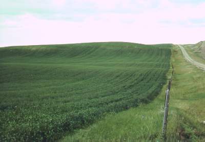
Figure 4. Class 4 land due to category 3 topography requiring a special system design due to steep slopes.
Class 5R - temporarily irrigable (undergoing reclamation): Land undergoing reclamation after the implementation of an appropriate improvement, such as drainage or canal lining. Class 5R land shall be added to the assessment roll as acres subject to a terminable agreement, for the purpose of promoting reclamation. Class 5R land shall be reviewed after the land has undergone reclamation for five irrigation seasons, after which the land shall be upgraded to an irrigable class (Class 1, 2, 3, or 4) if it meets the requirements, or remain as Class 5R for an additional 5 years. If significant improvement has not been achieved within a 10-year period to upgrade the land to an irrigable class, then the land shall be rated Land Class 6, nonirrigable, and the terminable water agreement shall be discontinued. Land in this class is suitable for irrigation by gravity and sprinkler methods or by sprinkler methods only.
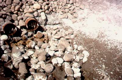
Figure 5. Subsurface drainage tile to remove excess water and salts for reclamation of land rated Class 5R.
Class 5 -nonirrigable (pending): Land in this class is considered not suitable for irrigation under existing conditions, but has sufficient potential to warrant segregation for additional investigation or improvement. The limitations of Class 5 may include one, or more, of the following: poor drainability, a high water table, very poor soil structure, and excess salinity and/or sodicity.
Two subclasses are recognized in LAND CLASS 5:
1. Class 5 - Nonirrigable, pending a more detailed investigation. Limitations are such that a more detailed soil, drainability or land development feasibility study may be required.
2. Class 5 - Nonirrigable, pending the implementation of an improvement. An improvement such as canal lining or improved surface or subsurface drainage may be required to upgrade this land to an irrigable class or Class 5R.
Class 5 is a tentative land class - changed to either an irrigable class or rated Class 6, nonirrigable, upon completion of the detailed study or implementation of an improvement. The topography of this land may range from level to moderately sloping, simple, or complex slopes.
Class 6 - nonirrigable: This class may consist of steep, rough-broken, or badly eroded land, or land having soils of very poor structure, very coarse texture, excess salinity and/or sodicity, poor drainage, shallow soils over gravel or bedrock, or other deficiencies not feasible to improve. Class 6 land may also include Land Classes 1 to 5 which cannot be separated out due to small size, the intensity of the investigation, or the purpose of the project.
Land class determination
The land class is determined by combining the soil category (S) and the topography category (T).
Land class symbol
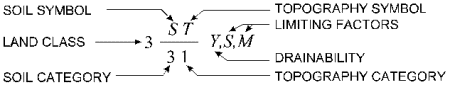
All combinations of "S" and "T" are categorized as follows:
Class 1: Excellent capability with no significant limitations for irrigation.
Class 2: Good capability with moderate limitations for irrigation.
Class 3: Fair capability with moderately severe limitations for irrigation.
Class 4: Restricted capability requiring a special system design and/or special management.
Class 5R: Temporarily irrigable, undergoing reclamation. Class 5R land may be the subject of a terminable water agreement for the purpose of promoting reclamation.
Class 5: Nonirrigable, pending a detailed investigation or implementation of an improvement. Land within this class may be upgraded to an irrigable class or will be rated Class 6.
Class 6: Nonirrigable.
Appendix A - Intensity of Investigation
Level II investigation (high intensity)
A. Purpose
This level may be used for:
1. Determination of acres to be irrigated.
2. Guide for proper land management under irrigation and for increased production.
3. Guide for land upgrading and improvement.
B. Bases of investigation
1. Existing information: previous land classification, soil survey reports, surficial geology maps, geology maps, and groundwater level records.
2. Aerial photograph interpretation.
3. Soil profile morphology and site description.
4. Ground touching.
5. Soil chemical and physical data.
C. Inspection Density
Investigation density is at least 10 soil investigation sites per 160 ac. A minimum of three 2-m and one 3-m deep sites shall be described and sampled per 160 ac. A minimum of one 3-m site and one 2-m site shall be described and sampled for parcels 40 acres or less. The purpose of the 3-m site is to check for shallow bedrock and a water table. If shallow bedrock or a shallow subsurface water table are present, more 3-m sites are required.
Solonetzic landscapes will require a higher intensity of investigation (Table A1). Additional 1-m inspection sites are required to characterize Solonetzic landscapes.
Table A1. Minimum soil sampling and investigation sites for Solonetzic landscapes. |
Area investigated (acres) | Soil sampling site depth |
1 m | 2 m | 3 mz | Total |
< 40 | 1 | 2 | 1 | 4 |
40 - 80 | 3 | 2 | 1 | 6 |
81 - 100 | 4 | 2 | 2 | 8 |
101 - 160 | 7 | 2 | 3 | 12 |
z More 3-m holes are required if shallow bedrock or a water table are found or suspected.
D. Soil Sampling
Soil samples shall be taken for standard chemical analyses to represent the 0 to 0.5, 0.5 to 1 and the 1 to 1.5 m depths in the minimum number of required sampling sites. Soil samples in Solonetzic landscapes shall be taken within the B horizon to determine whether a soil is classified in the Solonetzic order, and within the upper and lower C horizons to determine whether the salinity profile is regular (salinity and sodicity increase with depth) or inverted (salinity and sodicity are higher near the surface).
E. Map and report information
1. Scale of Maps: 1:5 000
2. Area of Mapping: 2 ac for soil units and 10 ac for topographic units.
3. Map and Report: The map shall show the following information:
a. Physical land features; e.g. water bodies, rock exposures, sloughs, etc.
b. Cultural land features; e.g. roads, canals, farmsteads. Temporary or movable objects are not considered.
c. Land classification units identified by boundaries and described accordingly.
d. Land irrigability classification expression.
An accompanying report usually contains a description of the land units and recommendations for land management and/or improvement under irrigation (Fig. A1 and A2).
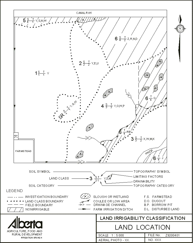
Figure A1. Sample Level II land classification map (not to scale).
Legend
| Land Classes | Soil Categories | Topography Categories |
| 1 - Excellent irrigation capability | 1 - Irrigable - Excellent | 1 - Irrigable - Gravity |
| 2 - Good irrigation capability | 2 - Irrigable - Good | 2 - Irrigable - Sprinkler |
| 3 - Fair irrigation capability | 3 - Irrigable - Fair | 3 - Irrigable - Special System |
| 4 - Restricted irrigation capability | 4 - Nonirrigable | 4 - Nonirrigable |
| 5R - Temporarily irrigable, undergoing reclamation | | |
| 5 - Nonirrigable, pending further study | | |
| 6 - Nonirrigable | | |
.
| Soil Limitations | Topography Limitations | Drainability |
| A - combination of minor soil limitations | F - surface drainage | X - moderately to rapidly permeable |
| B - brush/tree cover | G - steep slopes | Y - slowly permeable |
| D - low permeability/undesirable structure | I - periodic flooding | Z - relatively impermeable |
| E - erosion damage | J - field size, shape | |
| K - shallow profile development | P - stoniness | |
| L - geological layering | RB - rough-broken | |
| M - low moisture holding capacity | U - earth moving | |
| N - sodicity | | |
| R - shallowness to bedrock | | |
| S - salinity | | |
| W - excessive wetness | | |
Remarks
The majority of this quarter is suitable for irrigation development. The Class 1, 2, 3, and 4 areas are suitable for irrigation. The Class 5R area is temporarily irrigable, undergoing reclamation. The Class 5 and 6 land is rated nonirrigable. The Class 5 land has potential to be upgraded to an irrigable class, pending implementation of an improvement.
 | Excellent irrigation capability. The soils are dominantly Orthic Brown with a minor occurrence of Rego Brown. They have developed in less than 1 m to greater than 1 m of clay loam to sandy clay loam lacustrine, underlain by clay loam till. The topography is nearly level and is suitable to be developed for gravity or sprinkler methods of irrigation. Considerable earth moving would be required if developed for gravity irrigation. |
 |
Good irrigation capability. The soils are Orthic Brown to Rego Brown, developed in less than 1 m of loam to clay loam lacustrine, underlain by clay loam till. They are nonsaline but are limited for irrigation by their shallow profile development, mainly as a result of erosion (E). The topography is gently undulating, suitable for sprinkler irrigation only. |
 |
Fair irrigation capability, suitable for sprinkler irrigation only. The soils in this river flat are Orthic to Rego Brown with a minor occurrence of Orthic Regosol, developed in less than 1 m of fine sandy loam, underlain by sand and gravel. They are limited for irrigation by the presence of a water table (W) at approximately 1.5 m, low water holding capacity (M) and shallow depth to lime (K). The topography is very gently undulating with 2 to 5% slopes. |
 |
Restricted irrigation capability due to steep, complex slopes of 10 to 15%. The soils are dominantly Orthic to Rego Brown, stony with a minor occurrence of Gleyed Brown, developed in clay loam to sandy clay loam hummocky till. The imperfectly drained Gleyed Brown soils are located in depressions. A special system design is required to prevent runoff, erosion and ponding in depressions. A low rate of water application is essential. |
 |
Temporarily irrigable, pending the outcome of reclamation. Subsurface drainage has been installed to reclaim this area. The soils are moderately saline and sodic. |
 |
Nonirrigable, pending a more detailed investigation and implementation of reclamation measures. The soils are nonirrigable due to shallow groundwater at less than 1 m below the surface (W) and excessive salinity (S) and sodicity (N). |
 |
Not suitable for irrigation due to shallow bedrock (R) at approximately 1 m, and Solonetzic soils that are saline and sodic (N), and slowly permeable due to poor soil structure (D). |
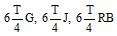 |
Nonirrigable due to steep complex slopes (G), the small size and irregular shape of the field (J) and rough-broken topography (RB). |
Statistical Summary (acres, approximately)
| Irrigable: | 102 | | Farmstead and Dugout: | 3 |
| Temporarily Irrigable: | 4 | | Canal R/W: | 7.4 |
| Nonirrigable: | 42 | | River: | 1 |
| Prepared | _________________________________ | Location | _________________________________ |
Reviewed | _________________________________ |
Date | _________________________________ |
Figure A2. Sample Level II land classification report.
More information and copies of the Standards for the Classification of Land for Irrigation in the Province of Alberta may be obtained from:
Alberta Agriculture, Food and Rural Development
Irrigation Branch
Agriculture Centre
100 - 5401 1st Avenue South
Lethbridge AB Canada T1J 4V6
Telephone: 403-381-5140
Fax: 403-381-5765
Website: www.agric.gov.ab.ca |
|