| | RTW This Week has created a weekly feature of weather station data available from Alberta Agriculture and Rural Development (ARD). Ralph Wright from ARD's Agro-Meteorological Applications and Modelling Unit provides the near real time station data maps of the Province.
.
November 15, 2010 Update
Looking at precipitation accumulations over five-year periods successively back to 1961, yields 46 five-year periods for comparisons. For many parts of the Province, the past five-years has been unusually dry. As of October 31, 2010, across much of the Peace River region as well as in several small pockets scattered through the Province, precipitation accumulations over the past five years have been extremely low, with accumulations this low, occurring less than three times over the past 50 years. Furthermore, about half of the Province is currently running long-term precipitation deficits that are classified as being at least one-in-six year lows. Thus, across many areas of the Province, a few good wet years are needed to balance off the dry years that we have seen lately.
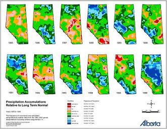
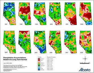
Province wide, many areas are still seeing the effects of at least 10 years of unusually dry weather. What makes the last 10 years or so really note-worthy is the lack of unusually wet years. If we look at the image showing 12 years of precipitation accumulations relative to normal, from 1997 to 2008, and compare it to the image showing the 12 years from 1985 to 1996, the absence of blue (wet areas) on the 1997 to 2008 image is obvious. Wet years are very important for recharging lakes, rivers, marshes, sloughs and groundwater reserves, and are necessary component to Alberta’s Hydrological cycle.
If we use history as a guide, looking back over the past 50 years, we often see wet years following dry years and dry years following wet years, with no consistent, nor predictable pattern evident. In addition, in any given year, its common to see parts of Alberta that are unusually wet and other parts that are unusually dry. This spring was a prime example of how dry spells can end suddenly, with many areas across the Province transitioning from extremely dry conditions to conditions of excess moisture in the space of a several weeks. There appears to be some truth to the old saying, “In Alberta, if you don’t like the weather, wait five minutes!"
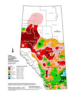
Click on the map for larger image for the 5-Year Precipitation Accumulations Relative to Long Term Normal - 252 K
Click on the map for larger image of the 1997 to 2008 precipitation accumulations relative to normal - 309 K
Click on the map for larger image of the 1985 to 1996 precipitation accumulations relative to normal - 319 K
AgroClimatic Information Services (ACIS) has more weather, climate and related agriculture features to help with long-term planning and decision-making throughout the year. To view real time station data and maps, click here.
For more information, contact:
Ralph Wright
Agro-Meteorological Applications and Modelling Unit
Alberta Agriculture and Rural Development
Ph: 780-427-3556
Email: ralph.wright@gov.ab.ca
|
|