| |
Depression Bottom Salinity | |
| |
|
|
| |
|
|
| |
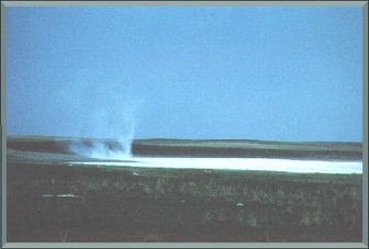
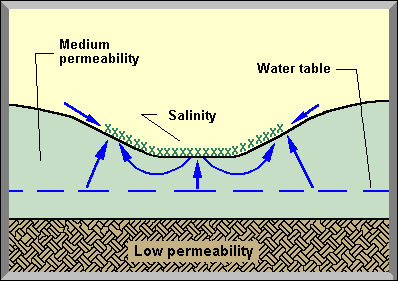
This type of salinity occurs in depressions or drainage courses. Surface water flows slowly over and is trapped temporarily in the low lying areas until the water drains off and/or infiltrates the soil. The groundwater at the edge of the water body moves laterally upslope through the upper soil in an unsaturated state. Once the surface water has disappeared, groundwater from the water table rises by capillary action to the surface in the previously ponded area. Depression bottom seeps are well-defined on aerial photographs with distinct, rounded edges. This type is the predominant type in the province. The seeps occur in several landscapes with poor drainage, particularly in rolling and hummocky areas and are often associated with sodic soils.
Page developed by Jan Kwiatkowski. |
|
| |
|
|
| |
Other Documents in the Series |
|
| |
Salinity Classification, Mapping and Management in Alberta
Artesian Salinity
Contact/Slope Change Salinity
Coulee Bottom Salinity
Depression Bottom Salinity - Current Document
Outcrop Salinity
Slough Ring Salinity
Irrigation Canal Seepage Salinity
Natural/Irrigation Salinity
|
|
| |
|
|
| |
For more information about the content of this document, contact Karen Raven.
This document is maintained by Laura Thygesen.
This information published to the web on February 12, 2004.
Last Reviewed/Revised on December 4, 2017.
|
|