| |
Groundwater quality in the Battersea drainage basin was monitored between 1995 and 2001 to characterize groundwater sources and to determine whether the groundwater is vulnerable to agricultural contamination. Groundwater in a shallow sand aquifer in the Battersea drainage basin is naturally of good quality, but application of manure and fertilizer at rates greater than crops require can cause increased concentrations of nitrate, chloride and magnesium. Shallow groundwater in fine-textured sediments is also vulnerable to contamination. Groundwater below about 6 metres in fine-textured sediments in the Battersea drainage basin is not vulnerable to contamination. Transport of contaminants in shallow groundwater could eventually reduce the quality of some surface water bodies, particularly those with low flow such as irrigation return flow streams. The most effective way to maintain groundwater quality is to apply manure and fertilizer only at rates crops require.
Why was the study conducted?
Agriculture is vital to Alberta’s economy. During the last 25 years, the number of cattle in Alberta has more than doubled, and the area assessed for irrigation has increased by 66%. Studies show that as agricultural intensity increases, the potential for groundwater contamination also increases. Application of manure and/or inorganic fertilizer at rates greater than crops require can result in leaching of nitrate, phosphorus, salts, and pathogens to shallow groundwater. The majority of rural Albertans rely on groundwater for domestic use and need to maintain a clean and reliable supply.
The Battersea drainage basin is located about 25 km northeast of Lethbridge in the Oldman River basin. The study area (Fig. 1) is predominantly irrigated farmland and contains a high density of confined animal feeding operations. Residents of the Battersea drainage basin have long benefited from the presence of a shallow, high-quality groundwater supply.
Goals of this study were to characterize the various groundwater sources in the Battersea drainage basin, including flow rates and quality, and to determine whether groundwater quality changed between 1995 and 2001.
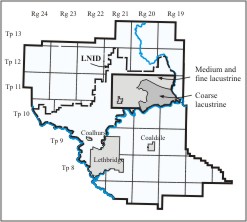
Figure 1. The study area, showing the area underlain by coarse-textured and fine-textured lacustrine.
How was the study conducted?
Narrow-diameter water wells (called piezometers) were installed in 1994 at various depths below ground in the Battersea drainage basin. The piezometers were used to determine groundwater flow directions and velocities. Special sampling techniques were used to determine approximate groundwater ages. Sediments were described during piezometer installation, and groundwater characteristics were later related to characteristics of the sediments. Groundwater samples, collected from the piezometer network once or twice a year from 1995 to 2001, were analyzed for nutrients, salts and trace elements.
Data were analyzed using two statistical methods to determine whether groundwater chemistry changed with time. Changes with time in nitrate and salt concentrations at each piezometer were evaluated using linear regression. Piezometers were also divided into groups, and changes with time in nitrate and salt concentrations were evaluated for each group, using a statistical method called mixed modeling. In some cases, changes might not be significant for the group of piezometers as a whole, even though several piezometers within that group have significant changes in nitrate or salt concentrations based on linear regression.
What did we learn?
Groundwater sources in the Battersea drainage basin
Surficial geology at the ground surface for most of the prairies is glacial till (predominantly medium- to fine-textured sediments deposited directly by a glacier). The till is often overlain by lacustrine sediments, which were deposited in lakes during and after glaciation. The lacustrine sediments range in texture from coarse (sand) to fine (clay). Within the Battersea drainage basin, the lacustrine sediments range from 6 metres to 27 metres thick, and the underlying till is about 60 metres thick over sandstone and shale bedrock (Fig. 2).
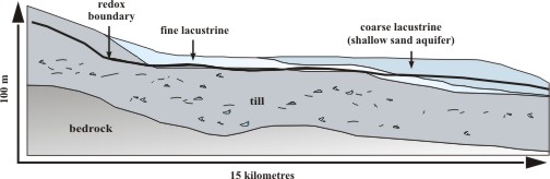
Figure 2. Geologic cross-section through the study area.
In the eastern part of the Battersea drainage basin, the lacustrine sediments are coarse-textured and form a shallow sand aquifer (groundwater supply) that covers about 10,000 hectares. The aquifer is up to 27 metres thick near the junction of the Little Bow and Oldman Rivers, and has supplied water to residents of the area since the early 1900s. The sand aquifer thins to the north and west, where it grades into medium-textured lacustrine sediments along the boundaries. The medium-textured lacustrine sediments grade to fine-textured lacustrine sediments at slightly greater depths. Fine-textured lacustrine sediments also occur between the sand aquifer and the underlying till (Fig. 2).
The shallowest geologic layers are usually brown-colored and fractured from weathering that occurred during periods when the water table (the top of the groundwater zone) was lower than it is today. These sediments are oxidized, that is they have been changed by reaction with oxygen. At greater depths, sediments are grayish-colored, unfractured, and reduced – they haven’ t interacted with oxygen. The boundary between the upper oxidized zone and the lower reduced zone is called the redox boundary. It occurs between the depths of about 3 metres and 25 metres in the study area, but is most commonly about 4 to 6 metres below ground. Fractures cause groundwater to flow more quickly in oxidized till and fine lacustrine sediments than it does below the redox boundary.
Data collected in southern Alberta show that nitrate never occurs in groundwater below the redox boundary, in the sand aquifer or in fine-textured sediments, because naturally-occurring bacteria use the nitrate as a food source in a process called denitrification. Denitrification was not found to occur in oxidized till or coarse to fine lacustrine sediments. This is because denitrification requires the presence of reduced sulfur or organic carbon, which tend to be much greater in reduced sediments.
Groundwater flow in the study area
A portion of the rain, snow and irrigation water that falls on land infiltrates through the soil zone to the water table, where it becomes groundwater. This process is called recharge. Most recharge in the Battersea drainage basin flows laterally through the shallow sediments (approximately the top 5 metres in till and fine lacustrine, but to greater depths in the sand aquifer), and is either used by plants, lost to evaporation, or is discharged to canals, surface drains, the Oldman River or the Little Bow River. Groundwater flows through the sand aquifer atabout 20 to 70 metres a year and through the more clay-rich sediments at less than 5 metres a year. Only a small percentage of recharge infiltrates to deeper ground-water in the underlying till and lacustrine sediments.
Interpretive grouping of piezometers
The 64 piezometers that were regularly monitored between 1995 and 2001 were divided into four main groups, based on geology, depth and oxidation state. The first three geologic groups – coarse lacustrine, fine lacustrine, and till – are located mainly in oxidized sediments, although three of the 14 piezometers in the “Manure Plot - Sand” group were installed in reduced sediments. The fourth major geologic group consisted of all three types of sediments that occur below the redox boundary (Table 1).
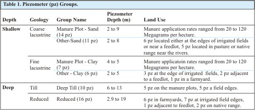
For the “Reduced” group, 7 of the 16 piezometers were located in reduced till, 4 were in reduced fine lacustrine, and 5 were in reduced coarse lacustrine. Piezometers in the coarse and fine lacustrine groups were installed at relatively shallow depths, where analyses indicated the groundwater recharged less than 40 years ago. Piezometers in the “Deep Till” group were installed in groundwater that mainly recharged more than 1000 years ago. Five of the 16 piezometers in the “Reduced” group were installed in modern groundwater, and the rest were installed in very old groundwater.
The two shallow lacustrine groups were each further divided based on land use. Piezometers installed on research plots of irrigated silage barley, where manure and fertilizer application were controlled for research purposes, are called the “Manure Plot-Sand” and “Manure Plot-Clay” groups. Manure application rates on some research plots were greater than crops require, up to 120Megagrams per hectare (53 tons per acre).
Piezometers in the remaining two shallow groups (“Other-Sand” and “Other-Clay”) were installed mainly at the edges of irrigated fields, or in pasture or native range near the rivers (Table 1).
Salt, Iron and Manganese concentrations
Much of the groundwater in southern Alberta contains naturally high salt concentrations. Groundwater in till and fine lacustrine sediments commonly exceeds drinking-water guidelines for sodium and sulfate. Groundwater in the till, particularly in reduced till, also contains high manganese concentrations (Table 2). High sodium, sulfate and manganese levels occur naturally in clay-rich sediments.
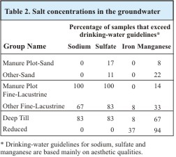
In contrast, groundwater chemistry in the sand aquifer is relatively fresh, because it receives a high proportion of new recharge from irrigation and precipitation. For example, all groundwater samples in the aquifer met Canadian drinking-water guidelines for sodium, and only 11% to 17% of samples exceeded the guideline for sulfate (Table 2).
Groundwater Nitrate and Chloride in the shallow sand aquifer
Several factors indicate nitrate and chloride in the sand aquifer are derived mainly from fertilizer and manure. Concentrations decrease with depth and are generally higher in irrigated areas than below native range and pasture. Nitrate and chloride increased significantly between 1995 and 2001 (based on linear regression) in about one-third to one-half of piezometers in the shallow aquifer (Table 3).
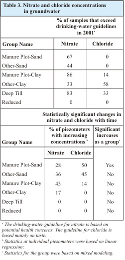
The percentage of samples with increasing nitrate in the “Manure Plot-Sand” group was lower than the percentage with increasing chloride, because 3 of the 14 piezometers were installed in reduced sediments where denitrification prevents increases in nitrate. Using the more rigorous statistical test based on grouping the piezometers, increases in the concentrations of nitrate, chloride and magnesium at the “Manure Plot-Sand” group were statistically significant with time, but the increases at the “Other-Sand” group were not.
Groundwater Nitrate and Chloride in oxidized fine lacustrine sediments and till
Oxidized till and fine-lacustrine sediments in southern Alberta contain naturally high nitrate and chloride, in addition to naturally high salt and manganese concentrations. Nitrate and chloride in these sediments tend to increase with depth, with the highest concentrations in groundwater that recharged long before the introduction of agriculture on the prairies. Nitrate concentrations in the “Deep Till” group were often 10 to 20 times greater than the drinking-water guideline. As expected, nitrate and chloride did not increase with time in any piezometers in this group (Table 3).
Nitrate and chloride in till and fine lacustrine sediments above 5 metres depth can be derived from both agricultural and natural sources. The two sources can become mixed so they are not always clearly identifiable.
For the two groups installed in shallow fine lacustrine (Manure Plot-Clay and Other-Clay), groundwater chemistry data suggest that at least 50% of the piezometers do not contain geologic nitrate. Nitrate increased with time from almost non-detectable to significantly higher concentrations in three of the seven “Manure Plot-Clay” piezometers, and in one of the six “ Other-Clay” piezometers. The increasing nitrate in these piezometers, combined with land-use data, suggests leaching from agricultural sources.
Groundwater Nitrate and Chloride in reduced sediments
Nitrate was not detected below the redox boundary due to denitrification. As expected, nitrate and chloride did not increase with time in any piezometers in the “Reduced” group, consistent with denitrification and the predominance of relatively old groundwater in this group.
Potential impact of groundwater contamination on surface water
Most shallow groundwater flows laterally. Some of it discharges into surface water. In the study area, canals and surface drains receive groundwater and transport it to the Little Bow and Oldman Rivers much more quickly than if the groundwater had to travel through underground sediments to the rivers. Data collected in the study area suggest that at least 75% of nitrate is lost from groundwater as it discharges to surface water, due to uptake by plants and denitrification associated with organic-rich drain-bottom or river-bottom sediments. However, chloride is not lost from groundwater as it discharges to surface water.
Data from the study area can be used to estimate the effect on water quality in the Oldman River if groundwater contamination were to become widespread. About 10% of the land area of the Oldman Basin is irrigated. Most shallow groundwater in the irrigated portion of the Oldman Basin probably contains lower nitrate and chloride than shallow groundwater in the study area. If groundwater nitrate and chloride in the entire irrigated 10% of the basin reached the median levels currently measured in the study area, it is estimated nitrate in the Oldman River would rise by 18% to 45% (from 0.08 to 0.12 milligrams per litre), assuming 90% of nitrate is removed by denitrification before discharging to surface water. Similar estimates suggest chloride would rise by 22% to 57% (from 4 to 6.3 milligrams per litre). The drinking-water guideline for nitrate is 10 milligrams per litre. The guidelines for chloride are 250 milligrams per litre for drinking water and 100 milligrams per litre for irrigation. Smaller water bodies, including canals and surface drains, would be more significantly affected than the Oldman River.
Summary and conclusions
The shallow sand aquifer in the Battersea drainage basin has naturally good groundwater quality, with relatively low concentrations of salts and manganese. In contrast, groundwater in oxidized till and fine-textured sediments adjacent to and underlying the sand aquifer commonly exceeds drinking-water guidelines for sodium, sulfate and nitrate. The high salt and nitrate concentrations occur naturally in fine-textured sediments.
Groundwater in reduced till and fine lacustrine sediments that underlie the oxidized sediments contains lower salt concentrations and no detectable nitrate, but naturally-occurring manganese almost always exceeds the drinking-water guideline. Nitrate never occurs in reduced sediments because denitrification removes all nitrate from below the redox boundary, in both coarse-textured and fine-textured sediments in the study area.
Most groundwater above 6 metres in the Battersea drainage basin recharged less than 40 years ago. Application of manure or fertilizer at rates greater than crops require can cause nitrate, chloride and magnesium concentrations to increase in shallow groundwater in both coarse-textured and fine-textured sediments. These conclusions are consistent with studies conducted in other agricultural areas of the world.
Predictions based on the data suggest transport of contaminants in shallow groundwater in both coarse-textured and fine-textured sediments could eventually reduce the quality of some surface water bodies, particularly those with low flow such as irrigation return-flow streams.
Nitrate and salt concentrations did not increase with time in groundwater below about 6 metres in either oxidized or reduced till and fine lacustrine sediments, consistent with other data indicating this groundwater recharged dominantly before the introduction of agriculture on the prairies. The data indicate this groundwater has a low vulnerability to agricultural contamination.
The most effective way to maintain groundwater quality is to apply manure and fertilizer only at rates crops require.
This fact sheet on Groundwater Quality in the Battersea Drainage Basin is one of a series of information bulletins on agriculture and resource management produced by the Irrigation Branch, Alberta Agriculture and Food.
For more information on groundwater quality, contact Joan Rodvang of the Irrigation Branch at (403) 381-5140 or use the Alberta Government Riteline, toll-free, 310-0000.
IB004-2002
|
|