| |
Mapping Water Erosion Potential in Alberta | |
| |
|
|
| |
|
|
| | A map displaying water erosion potential at 1:100 000 scale was prepared for agricultural land in Alberta. The map involved calculation of erosion rates for 26 819 AGRASID soil polygons using the Water Erosion Prediction Project (WEPP) model. In the calculation, erosion rates were a function of polygon-specific information relating to climate, soil, and landscape conditions, and uniform landuse (summer fallow) scenario.
The WEPP model predicted erosion rates that ranged from 0 to 783 Mg ha-1 yr-1. Rates were the lowest on flat hillslopes and the highest on hillslopes adjacent to river valleys where the slopes were greater than 20%. These erosion rates were generalized into five classes to prepare a water erosion potential map. According to this classification, 67% of the AGRASID polygons had low or negligible erosion potential, 14% moderate, and the remaining 19% of the polygons had either high or severe erosion potential. Additional statistical analysis showed that the improvement districts of Kananaskis and Waterton had the highest proportion of severe water erosion risk areas within the agricultural area of their respective municipalities, and the counties of Beaver and Barrhead had the lowest erosion risk rates.
A land-cover mask was prepared to evaluate the relevancy of the water erosion potential map. The test involved visual comparison of water erosion classes against the landuse classes derived from 1993 satellite image interpretation (land-cover mask). In this comparison, it was expected that areas of high or severe erosion potential would be under permanent cover, and areas of negligible and low erosion potential would be under annual crop cover. For the majority of the polygons, this was true. However, there were a small number of polygons that did not meet this assumption, and these polygons need further investigation to explain the discrepancies.
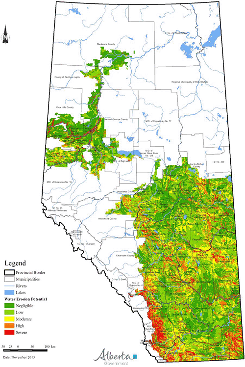
Generalized water erosion risk in Alberta under bare-soil summer fallow landuse conditions. |
|
| |
|
|
| |
For more information about the content of this document, contact Andy Jedrych.
This document is maintained by .
This information published to the web on July 30, 2015.
|
|