| | Protocol_Boundaries |
Carbon Sequestration Changes within Soil Zones
The Parkland and Dry Prairie regions of Alberta are recognized as distinct ecozones based on a number of agricultural interpretations (e.g. yield, cropping systems). The boundary between these regions, or ecozones is based on:
- Soil zone: The Black–Dark Brown soil zone boundary is an important demarcation of soil organic matter levels and the potentials for soils to sequester or emit carbon based on farm management practices;
- Moisture regime: The boundary coincides with the –300 Climatic Moisture Index (precipitation minus evapo-transpiration); and
- Historical precedence: Crop and fertilizer recommendations, research analysis and coefficients have historically been separated by soil zone boundaries.
Greenhouse gas removal coefficients for soil carbon sequestration are similar within an ecozone but differ between the two ecozones (McConkey et al. 2007, Vanden Bygaart et al. 2008). As a result, ecozones have been used as a basis for identifying the different sequestration factors for different parts of the province for both tillage system management and summerfallow reduction activities.
Alberta’s digital soils database (AGRASID, Brierley et al. 2001) describes the change from Dry Prairie to Parkland ecozones shown in Figure 1. The precise location of the boundary has been identified using the Soil Group Map of Alberta (Alberta Land Resource Unit, 1975).
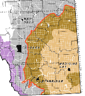
Figure 1. The boundary between Dry Prairie and Parkland ecozones (Alberta Land Resource Unit. 1995)
The Conservation Cropping Protocol is an updated version of the now expired Tillage System Management Protocol. The Conservation Cropping Protocol continues to provide opportunities for farmers to earn carbon off credits by increasing soil carbon levels through no till management and reducing greenhouse gas emissions from lower fuel use. There is also new opportunity for farmers in the Dry Prairie ecozone who replace areas of summerfallow with continuous cropping using no till management, since a growing crop seeded with low disturbance no till equipment increases biological carbon capture and storage compared with uncropped fallow fields. More information about farm record evidence needed to use the Conservation Cropping Protocol can be found here.
For the purposes of the Conservation Cropping Protocol, the boundary between the Dry Prairie and Parkland ecozones is the fence-line on the Dry Prairie side of the quarter sections located on the boundary line. This is the same boundary that was used in the expired Tillage System Management Protocol.
For more information about the content of this document, or to obtain electronic files of boundary line locations (e.g. Excel, Access, Shape, pdf, kml) contact Sheilah Nolan, Climate Change Specialist.
References:
Alberta Land Resource Unit. 1995. Soil Group Map of Alberta. Research Branch, Agriculture and Agri-Food Canada, see: http://www1.agric.gov.ab.ca/soils/soils.nsf/soilgroupmap?readform
Brierly, J. A., T.C. Martin and D.J. Spiess. 2001. Agricultural Region of Alberta Soil Inventory Database (AGRASID 3.0). Soil Landscape User’s Manual, see: http://www1.agric.gov.ab.ca/$department/deptdocs.nsf/all/sag6903
Government of Alberta. Quantification Protocol for Conservation Cropping, version 1.0, April 2012
McConkey, B., D. Angers, M. Bentham, M. Boehm, T. Brierley, D. Cerkowniak, C. Liang, P. Collas, H. de Gooijer, R. Desjardins, S. Gameda, B. Grant, T. Huffman, J. Hutchinson, L. Hill, P. Krug, C. Monreal, T. Martin, G. Patterson, P. Rochette, W. Smith, B. Vanden Bygaart, X. Verg�, D. Worth. 2007. Canadian Agricultural Greenhouse Gas Monitoring Accounting and Reporting System (CanAG-MARS): Methodology and greenhouse gas estimates for agricultural land in the LULUCF sector for NIR 2006
Vanden Bygaart, A. J., B.G. McConkey, D.A. Angers, W. Smith, H. de Gooijer, M. Bentham, and T. Martin, 2008. Soil carbon change factors for the Canadian agriculture national greenhouse gas inventory. Can. J. Soil Sci. 88: 671-680.
|
|