| | Background | Current design standards | Site investigation and design | Soil sampling parameters used | Summary of site investigations | Conclusion | Ongoing study | Glossary
With the increasing concerns about manure storage in agriculture, a study was done to look into manure seepage from several earthen manure storages built 10 to 20 years ago. The storages had no engineering design and were not built to today's standards. They were located on a variety of soil conditions.
Here is a summary of the interim report on "A Survey of the Environmental Security of Earthen Manure Storage Ponds in Alberta."
Background
Earthen manure storages are either lined (clay, plastic or geotextile) or unlined in-ground facilities used to contain liquid manure, wash water and precipitation from a dairy, hog operation or livestock operation. Earthen manure storages should be designed to protect surface water and groundwater. Surface water is protected by storing liquids until they can be applied to land, at minimal risk of runoff, and provide maximum potential for manure nutrient uptake by cropland. Groundwater is protected by building the storage from highly impermeable materials, thus reducing the potential for lateral and vertical seepage. The study project was to assess the risk to groundwater and to evaluate design, construction, and maintenance practices for older earthen manure storages found in central Alberta.
Objectives
The information in this factsheet is based on detailed site investigations of five older earthen manure storages in central Alberta. The conclusions and recommendations are not based on statistical samples, but on individual measurements and findings from construction and maintenance practices of the time.
Study objectives:
| 1. | To provide an engineering evaluation of site investigation, design and construction practices used at older sites. |
| 2. | To determine the extent of seepage and contaminant transport from earthen manure storages located in a variety of soil and geological site conditions typical to Alberta hog operations. |
| 3. | To determine the factors that contribute to seepage and contaminant transport encountered at the earthen manure storage sites studied. |
| 4. | To determine if existing physical data sources (air photos, soil surveys, geological, and hydrogeological data) can be used to characterize the physical site conditions that affect seepage and contaminant transport from earthen manure storages. |
| 5. | To determine if the Geonics EM-31 (EM-31) electromagnetic inductance conductivity meter can be used effectively to indicate the existence and extent of seepage movement from earthen manure storages. |
| 6. | To determine if the EM-31 is a useful tool in the design of soil and water investigation programs. |
Current Design Standards
2000 Code of Practice recommendations
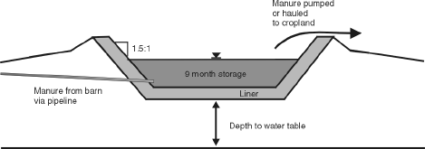
The 2000 Code of Practice for Responsible Livestock Development and Manure Management defines acceptable standards and practices for the design and operation of earthen manure storages in Alberta (see Figure 1). The Code covers siting, site investigation and design criteria for earthen manure storages as follows:
Siting criteria
The bottom elevation of the liquid manure storage facility must be constructed a minimum of 1 metre (3.28 ft) above the seasonal high water table (Sec. 2.4.11).
In any area subject to flooding, the earthen manure storage must be 1 metre (3.28 feet) above the 1:50 year floodplain, or 1 metre in elevation above the highest known flood level. Erosion control measures must be designed to withstand a 1:50 year flood.
Design criteria
Liquid earthen manure storage facilities must be designed and constructed to minimize odour nuisance and protect groundwater and surface waters (Sec. 2.4).
A minimum of nine months of storage volume must be provided to store all of the manure, wash water and water spillage produced by the operation (Sec. 2.4.5).
Stability of the material and method of emptying will determine side slopes, which, in any case, will be no steeper than 1.5:1 (Sec. 2.4.4).
There must be a run-on control system that prevents the flow of surface water into the liquid manure storage facility (Sec. 2.4.13).
A minimum of 10 metres (32.8 ft) of natural uniform material at a hydraulic conductivity no greater than 1 x 10 <+>- 6 cm/sec must be between the bottom and sides of the storage and above the uppermost identified groundwater source or a material that provides an equivalent or greater protection, with the design and construction approved by a professional engineer (Sec. 2.4.14).
Seepage monitoring may be required for liquid earthen manure storages (Sec. 2.4.16).
Site Investigation and Design
Physical data sources
Several of the more useful data sources include:
Soil survey data - Provides a reasonable approximation of soil types and depths. The main point is to ensure the soil is a clay till material with at least 15 per cent clay content, which, in turn, gives an indication that the soil permeability is sufficiently low.
Surficial geology maps - Provide an indication of the type and depth of surface material.
Water well logs - Provide information on water table depth, probable flow rates and an indication of the vertical soil profile data near the site and on land parcels adjacent to the site.
Hydrogeological maps - Provide information on groundwater depths, flow paths, and bedrock formations.
Aerial photography - A collection of 1:20,000 and 1:30,000 black and white photographs of the province.
Indirect site investigation
Electrical conductivity is an indirect measure of soil and soil pore water salinity. The electrical conductivity of the subsurface generally depends on the soil texture, soil chemistry, water content, metal content, soil porosity and pore water quality.
Using electromagnetic inductance, the EM-31 can measure the bulk electrical conductivity of the subsurface material to a depth of approximately 6 metres. Most earthen manure storages are generally 3 to 5 metres deep, well within the operational depth of the EM-31.
EM-31 readings were recorded onto a scaled map of the site. This information was digitized, and a two dimensional electrical conductivity surface map was generated with mapping software. High electrical conductivity readings are more indicative of seepage, as manure has a higher conductivity than many soils. Therefore, a high electrical conductivity should suggest seepage into the soil.
Monitoring
Eight sites were selected for investigation; four sites where the EM-31 displayed suspicious or unusual bulk electrical conductivity signatures and another four sites where the EM-31 showed a flat or uniform response. All eight sites had between four and six piezometer nests (small diameter wells) installed in triangular patterns downslope and one positioned upslope of the earthen manure storages. These piezometers were used for water sampling and for measuring hydraulic head (Figure 2).
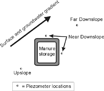
Figure 2. Piezometer locations relative to surface contours and manure storage locations
All test holes were bored and field logged to a depth of 7.6 metres or to auger penetration refusal (Figure 3). The upslope borehole was installed to obtain background samples for subsequent laboratory analysis. Downslope boreholes were placed within the anticipated location of the plume determined from the EM-31 data. Sample locations were arranged in a triangular pattern to fit the interpretation of local groundwater hydraulics from piezometric observation wells installed into the boreholes after sample procurement.
Soils were analyzed for chemical characteristics indicative of manure seepage and physical characteristics, thus allowing for the estimation of hydraulic properties. Multiple sampling sites were used to investigate the difference between upslope and downslope soil properties.
Water quality analysis was performed to assess the impact of earthen manure storage seepage on shallow groundwater quality.
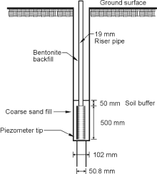
Figure 3. Schematic of an installed piezometer
Soil Sampling Parameters Used
| Physical tests |
|
|
|
|
|
|
|
|
|
|
|
|
|
|  |
| Chemical tests |
|
|
|
- electrical conductivity (EC)
|
|
|
|
|
- soluble salts: Ca, Mg, Na
|
|
- cation exchange capacity (CEC)
|
|
| Water sampling tests |
|
|
|
|
|
- total dissolved solids (TDS)
|
|
|
|
|
|
|
|
|
|
|
|
|
After the initial batch of soil and water sampling, five of the eight sites were chosen for more detailed investigation. Reasons for excluding the other three sites were travel distance, highly designed and constructed site locations as well as limited access to a site that included a cropped field. The subsequent six-month period involved numerous water level measurements, surveying, and additional soil sampling at the five remaining sites.
Summary of Site Investigations
Here are the results of the five sites chosen for more detailed investigation. To retain consistency with the original report, they are listed as Site 1, 2, 3, 5 and 8.
Site 1
Constructed in 1985, the manure storage serviced a 260 sow farrow-to-finish operation. The single stage, top loaded, gravity-fed manure storage is unlined and had no engineering design. Storage dimensions are 46 m x 44 m x 4 m. The soil consists of a 10 metre layer of silty sand overlaying clay till. The initial EM-31 survey yielded a uniform response, suggesting a low likelihood of seepage.
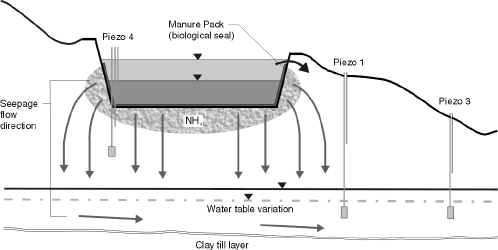
Figure 4. Schematic of seepage from a highly permeable site
An investigation of the data sources suggests that this earthen manure storage was built into a sand dune. The producer indicated there was some obvious seepage when the storage was first constructed. The natural biological sealing action of the manure is assumed to have caused the end to this seepage.
Ammonia was found in soil samples below the earthen manure storage, probably caused by periodic breakdown of the manure seal and intermittent seepage. Given that the surrounding soils are unsaturated, seepage is mostly vertical, which is probably why higher concentrations are found in the extreme downslope piezometer, along the clay till barrier and in a perched water table.
Summary of site 1 investigation
- Some seepage and contaminant movement is occurring at this site and is having a negative impact on the local shallow groundwater within the upper sandy soil layer. However, a continuous, severe contaminant plume from the manure is not evident.
- Most, if not all of the seepage from the manure at this site is through unsaturated flow and diffusion mechanisms.
- Preferential flow during periods when the manure seal has broken down is likely responsible for most of the contaminant movement at this site. The manure sealing is probably responsible for preventing the development of a major continuous plume from this site.
- The presence of a 6 metre deep clay layer between the surface sandy soil and underlying bedrock aquifers will prevent contamination. Sorption and denitrification of contaminants will reduce the risk to deep groundwater sources in the area.
- Under today's standards, a review of the remote site characterization data would have resulted in a recommendation to do a site-specific investigation. A qualified professional would have recommended a constructed clay liner, or a steel or concrete storage.
Site 2
This site provided storage for a 120 sow farrow-to-finish operation. The single stage, top loaded, gravity-fed manure storage was constructed in 1991 and is 37 m x 32 m x 3.5 m in size. It is unlined, was dug by trackhoe and has no engineering design. The soil consists of clay till with localized sand streaks. The water table is just below the storage bottom, and a discharge condition (when water flows toward the surface) exists around the storage.
Initial EM-31 survey results showed one area of higher electrical conductivity readings, suggesting a potential seepage plume. Subsequent boreholes in this area did not indicate any signs of seepage.
There is limited evidence of some seepage into the berm, as shown in the soil samples. The native topsoil, not removed before constructing the berm, appears to support some seepage, although water sampling showed no signs. A high natural water table around the structure is probably providing a significant back pressure, thus helping to contain the manure within the berm.
With respect to current standards, there are two areas of concern. The topsoil was not removed prior to construction, and there was no berm compaction.
Summary of site 2 investigation
- There is no evidence that seepage from this earthen manure storage is entering the shallow groundwater monitored at this site. Evidence of elevated total dissolved solids (TDS) levels in the water samples taken downslope of the storage were attributed to natural groundwater conditions. Elevated total coliform counts found in observation wells 47 and 75 metres east of the earthen manure storage were attributed to contamination of the observation wells during installation.
- Some seepage is occurring periodically through the downslope berm of the earthen manure storage; however, it is contained within the extent of the berm. This seepage is attributed to the clayey nature and the relatively high cation exchange capacity of the soils.
- The near total absence of seepage or contaminant movement is attributed to the watertight nature of the clay materials and the likelihood that a manure seal is developing at the bottom of the storage.
- The nature and characteristics of the soil and geologic materials were predicted by the available remote data for this site. A review of remote data prior to construction of the earthen manure storage would have prompted a preliminary site investigation, which would have led to a better earthen manure storage design and better quality control during construction.
Site 3
This site serviced a 700 pig feeder operation. The single stage, top loading, pump-fed manure storage was constructed in 1989 and has a storage dimension of 50 m x 25 m x 3.5 m. The unlined storage was dug by a bulldozer and had no engineering design. No berm compaction was observed, and the native top soil layer was not removed before excavation. Soil type is a gravelly clay till to 3 metres with a gravelly sand below. The water table is above the bottom of the storage and in a discharge zone.
The EM-31 survey did not yield any suspicious EM signatures. Soils are glacial tills with some small stones, generally classified as a sandy clay. There is a sandy gravel layer about 2.8 to 3.0 metres below the entire site.
Piezometer nests indicate recharge conditions upslope of the earthen manure storage, discharge conditions immediately downslope and a stable water table 75 metres downslope.
Summary of site 3 investigation
- Soil and water chemistry data show that very little seepage or contaminant movement is occurring from the earthen manure storage.
- There are indications that minor seepage is occurring through the poorly constructed berm.
- Downslope soil and water sampling show very little if any of the material is seeping beyond the berm or into the local shallow groundwater. Relatively high NO3 concentrations are found through the berm. As this environment is above the water table, it is unsaturated and aerobic, which implies a loosely packed berm.
- Seepage into the topsoil layer within the berm is causing elevated NO3, Cl and salt concentrations within that soil zone. Elevated levels of these chemicals in the soils immediately below the seepage zone suggest downward movement of the seepage waters.
- The lack of an extreme increase in either moisture content or NH4 concentration within the seepage zone suggests that seepage into the berm is periodic. This outcome implies that manure sealing is preventing seepage from occurring continuously into the topsoil seepage zone from the earthen manure storage.
- Seepage probably occurs for a short time after the storage is filled to the level where the topsoil layer exists and until the manure can clog the soil and prevent further seepage from occurring.
- Groundwater level monitoring shows that the earthen manure storage is constructed within an area of localized groundwater discharge. This hydraulic condition and the presence of a 1 metre thick, very dense sandy clay layer that forms the earthen manure storage floor are probably combining to prevent seepage through the bottom of this storage.
- A review of remote data prior to construction of the earthen manure storage would have prompted a preliminary site investigation. This investigation would have led to a better design, better quality control during construction and would have eliminated all seepage from the manure storage.
- By today's standards, this site would require an artificial liner system to counter both the high water table and sandy and gravely soils.
Site 5
This site provided manure storage for a 150 sow farrow-to-finish unit. The single stage, top loading gravity-fed manure storage was constructed in 1983. Storage dimensions are 35 m x 35 m x 4 m. The unlined storage was constructed by a bulldozer and had no engineering design. Soil type is gravelly clay till to 4 metres, overlaying a sandstone bedrock. A perched water table varied in depth from 2.5 to 4 metres below ground and is above the bottom of the storage.
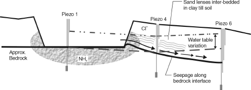
Figure 5. Seepage along bedrock interface where all soil was scraped from the EMS bottom.
The Initial EM-31 survey did not indicate any areas around the earthen manure storage that were higher in electrical conductivity. Therefore, no contaminant plume was suspected.
There is indication of a zone of seepage movement adjacent to the downslope corner of the manure storage that coincides with local sand layers. Evidence suggests that the top soil layer and tree roots in the berm may be contributing to this seepage. The bedrock-berm interface may act as a conduit for seepage. Water and soil sampling suggests that seepage is limited to the perched water table, and is not entering the bedrock layer.
Summary of site 5 investigation
- No evidence of a massive, continuous seepage plume from the earthen manure storage was found at this site.
- No clear evidence of NO3 or bacterial movement was observed at this site.
- Elevated chloride concentrations in the soils and shallow groundwater downslope of the manure storage showed signs of seepage.
- NH4 was shown to be moving into sand lenses and other preferential flow pathways from the storage.
- Evidence that seepage is occurring through the side of the storage (where a tree is growing into the berm) suggests tree root paths may be causing the high seepage rates at this location.
- The periodic development and breakdown of a manure seal may be controlling seepage into the sand lenses, the bedrock interface and tree root pathways around this storage.
- Evidence that seepage is occurring through sand streaks and along the bedrock interface supports the idea that a soil buffer should be present between the bottom of the earthen manure storage and the bedrock layer.
- The seepage mechanisms indicated at this site show the importance of proper siting and engineering design of earthen manure storages located in variable soil conditions.
Site 8
This site serviced a 110 sow farrow-to-finish operation. The single stage, top loading gravity-fed manure storage was constructed in 1980. Storage dimensions are 76 m x 25 m x 2.5 m. The storage was constructed by a bulldozer, with no engineering design, and is unlined. No efforts to remove topsoil were made. Soil type is sandy clay till, with some notable sand lensing. The water table is about 1 metre below the bottom of the storage.
The initial EM-31 survey showed two possible seepage plumes. One was attributed to the natural seepage that can readily occur in saturated subsoils, while the other plume had a more extended shape. Therefore, the soil and water investigation was designed with that area in mind.
Soils were generally of a clay till material. A sand streak was observed within the suspected plume zone. Soil and water samples taken within the sand lens showed elevated levels of chloride and ammonia.
Summary of site 8 investigation
- No major continuous seepage plume from the earthen manure storage exists at this site.
- A sand layer near sample Location 2 may be acting as a conduit for some minor localized seepage. The extent of the seepage through the sand lens could not be determined by the investigation procedures used in this study. A proper site investigation would have discovered the sand lens, and a more suitable design and construction using native materials would have resulted.
- No seepage is suggested in samples further downslope, suggesting the sand lens pinches out, and all seepage is contained within it. The buried topsoil layer may be responsible for some minor intermittent seepage.
- Soil and water chemistry anomalies, initially attributed to earthen manure storage seepage, might be better explained by infiltration and percolation of manure from a major spill event that occurred in July 1999. Contamination of the soil and water due to the spill event confused the interpretation of study results at this site.
- A preliminary site investigation with remote data would have identified the need for a site specific investigation to assess the environmental security of this site.
- Poor construction techniques, such as poor compaction of the berm and burying topsoil below the berm, might be responsible for some seepage and contaminant movement through the berm at the west end of this earthen manure storage.
Conclusions
Observations and data from these five sites confirm manure seepage mechanisms, contaminant movement, and site design and maintenance requirements for earthen manure storages.
Preferential flow paths
- Horizontal sand fissures and lenses within layered glacial tills.
- Vertical and horizontal weathering fractures in the upper till zones.
- Pathways caused by the growth of tree roots into the berm and sidewalls of the structure.
- A till-bedrock interface layer where the earthen manure storage floor was directly on top of the bedrock.
- Seepage into these preferential flow pathways appeared to remain localized due to confinement within the more general soil matrix.
Manure seals
- Manure seals should not be relied upon to prevent seepage from earthen manure storages in Alberta.
Pathogenic microorganisms
- Seepage based movement of pathogenic microorganisms from earthen manure storages is rare, but can occur in coarse, highly fractured or layered soils where coarse material lenses are present.
Site variability
- Unlined earthen manure storages must not be located in sandy soils or other high permeability materials.
- Sand lenses and soil fractures provide vectors for limited amounts of seepage and contaminant movement from earthen manure storages in glacial till soils.
- Avoid growing trees on berms or in the close proximity of an earthen manure storage (Figure 6).
- Due to the inability to characterize the subsurface environment and the unknown nature of subsurface soil anomalies, earthen manure storages in clay tills require some level of liner to protect against seepage into the fractures and fissures common to these soils.
- Modern site investigation methods continue to improve the siting of earthen manure storages.
Nutrient movement
- NO3 contamination of shallow groundwater due to earthen manure storage seepage seems significant only when sited in coarse soil materials.
- NH4 is mobile in sand lenses and other preferential flow pathways where they exist in the soils at the sidewalls of an earthen manure storage.
- NH4 is attenuated (bound to clay particulates) near the perimeter of the floor and sides of the earthen manure storage by most soils. Attenuated NH4 beneath the floors and sides of the storage may become a problem at the abandonment stage if aerobic conditions are allowed to develop within these soils.
Recommendations
EM-31 usefulness
- The EM-31 was not reliable in detecting seepage from earthen manure storages. The EM-31 readings could not differentiate depths, layering, fractures or coarse textured lenses. Seepage tends to be intermittent and of variable rates; therefore, the EM-31 survey may have missed the time period when the plume was evident.
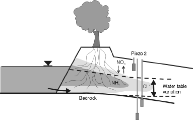
Figure 6. Tree roots in the berm promote preferential flow.
Construction standards
- Background resource data should be used to characterize the site and surrounding area. Air photos, topographic maps, soil survey reports, surficial geology maps, water well records, hydrogeology maps and cross sections are all useful with site characterization.
- Site-specific investigation is necessary to confirm the finding of the resource data review and to identify areas of high permeability. The intensity of the site investigation should be a joint decision between the designer and approving authority.
- All earthen manure storages, regardless of site characteristics, should be provided with some level of artificial protection. The protection required should be addressed within the engineering design of the storage, including the calculations needed to prove that the required level of protection has been met.
- Evidence that poor construction practices are causing seepage from an earthen manure storage suggests that better quality control is necessary. It is recommended that construction supervision be mandatory.
- A risk assessment tool should be developed to evaluate the vulnerability and value of the local groundwater and surface water being protected from the effects of potential seepage from an earthen manure storage. This information should be used to assess seepage protection required on a per project basis.
Maintenance
- Evidence of seepage due to tree roots in the berm shows that maintenance is important to continued performance. Operators of earthen manure storages should inspect and maintain the structures regularly.
Ongoing Study
Long term monitoring
- Water quality parameters at these sites should be monitored for the next several years. This monitoring will allow observation of long term seepage related trends in water chemistry and microbiological releases.
Additional site investigations
- Additional sites of different size, age, and hydrogeological characteristics should be investigated in the future.
Sampling parameters
- In the future, limit the soil chemistry parameters to the main indicators reviewed in this study.
- Soil analysis should be expanded to include microbiological indicators to find out if manure-related bacteria are moving into the soils near and below earthen manure storages.
- Two to three soil samples should be collected for analysis from each sample interval to allow statistical analysis of soil chemistry data.
- Water analysis should include cations, sulphates and carbonates, which are deemed to be strong indicators of seepage in clay soils.
Additional sampling locations
- Soil and water samples, from the berms and floor of earthen manure storages, should be collected to evaluate the downward movement of manure-related solutes.
- Cores should be collected from the side walls and bottoms of earthen manure storages to evaluate the reliability, consistency, and permeability of natural field scale manure seals.
Glossary
Hydraulic conductivity - measures the resistance of soils and rock to fluid flow. It is a measure of the unit volume of fluid moving through a unit area of soil per unit of time. Units are expressed as: m3/s/ m2 , which is commonly expressed as m/s.
Lithology - the study of the physical characteristics of soil and rock, also includes the study of soil layers. As used within this study, lithology refers to the logging and characterization of soils taken from auger flightings as boreholes were drilled.
Piezometer - a small diameter well, with a short screen or slotted section at the bottom end, which measures the hydraulic head of a discrete aquifer layer.
Discharge zone - a zone where groundwater movement is toward the surface. Conversely, in a recharge zone, groundwater movement is downward.
Prepared by:
Principal investigator - Bill MacMillan
Summary - Robert Borg and Peter Llewellyn
Source: Agdex 729-1. July 2001. |
|