| | Forecast production | Forecast limitations and Interpretation | Forecast dissemination | Weather warnings | Weather advisories | Forecast terminology and definitions | Growing degree days | Corn heat units
The Atmospheric Environment Service of Environment Canada is responsible for general weather services in Canada. The Alberta Weather Centre, one of eight regional centres, provides services for Alberta and northeastern British Columbia from its office in Edmonton.
The Alberta Weather Centre operates 24 hours a day, year round. Its primary responsibility is to issue weather warnings and advisories for severe or hazardous weather conditions, which could cause serious inconveniences or endanger life or property. In addition, forecasters continually issue weather information to serve the general public, the media, and industries such as agriculture.
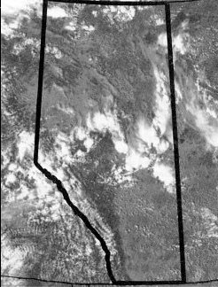
Figure 1. Satellite photo showing band of typical summer thunderstorms over central Alberta, causing isolated showers.
Further information, consultations, and local interpretations can be obtained from weather offices in Lethbridge, Calgary, Edmonton, and Grande Prairie.
Forecast Production
The latest in modern technology - satellites, conventional and doppler radars, computers, communications systems, lightning detectors, and other remote sensing devices - are used in conjunction with surface observations to gather information about the atmosphere. The information is sorted and analysed at major computing centres in Toronto and Montreal. While technology is used to identify and forecast medium and large scale weather systems, knowledge of how local topography influences the weather is necessary to determine how weather might affect a particular area.
Forecast Limitations and Interpretation
Topography and water bodies will cause the weather to differ over relatively short distances. Forecasters must generalize to keep the forecasts a reasonable length, but users can often modify the forecast to account for their own geographic situation.
A typical summer forecast may be read as follows:
"Today..a few clouds. Scattered late afternoon showers or thunderstorms. Probability of precipitation is percent 40 today."
This forecast can be understood to mean that for most of the day there will be more blue sky than cloud, although cloud may cover half of the sky for short periods. Some showers or thunderstorms can be expected in the region, but they should not be widespread. There is a 40 per cent chance of having showers at any point in the region.
Most of the area in the forecast will get no measurable rainfall. Some areas will get brief periods of rain ranging from a few sprinkles to a few millimetres, and a few small areas will receive 10 to 20 millimetres if a thunderstorm passes directly overhead. With these small scale, short-lived weather systems, it is impossible to forecast exactly the location or the timing of individual showers. Any forecast of precipitation amounts under these conditions attempts only to give a range of possible amounts over a given area. Even over one farm, it is possible rainfall could vary from a few millimetres over one section of land to none over another.
Forecasts are issued at 5 and 11 a.m. and at 4 and 9:30 p.m. In addition, forecasts are updated whenever a significant change in the weather occurs or is forecast to occur. A weather outlook for three, four and five days ahead is issued early every morning and late every afternoon.
Forecast content
Forecasts regularly include: sky condition, temperatures, wind direction and speed, and probabilities of precipitation. During the growing and harvest seasons the following information of interest to agricultural users is added: maximum and minimum relative humidities, drying indices, and more detailed forecasts of wind direction and speed as well as expected rainfall amounts. Forecasts include wind chill values above 1600 in the winter.
Forecast Dissemination
The Atmospheric Environment Service depends on newspapers, radio and television stations to distribute forecast information. Each media outlet decides when and how much of the information will be used.
Individuals or groups living within 60 kilometres of Edmonton, Calgary, Red Deer, Lethbridge, or Grande Prairie can obtain weather forecasts directly from the Atmospheric Environment Service. Weatheradio Canada, owned by Environment Canada, broadcasts 24 hours a day on the VHF-FM band at 162.400, 162.475 or 162.550 MHz from these sites. These signals cannot be received on regular AM-FM radios. Weatheradio receivers can be purchased at many radio shops, some with an automatic alert feature that is activated when a weather warning is issued.
Weather Warnings
The weather warning program is part of the public weather service. Warnings are issued whenever current or expected weather conditions might endanger lives or property. The bulletins will be issued, when possible, six hours in advance of the forecast weather conditions but normally no more than twelve hours before. The bulletins will give the regions affected, the time of occurrence, the duration and severity.
Weather warnings are issued for the following conditions:
Blizzard - Visibility less than one km due to snow or blowing snow; a combination of wind and temperature to result in wind chills 1600 or higher; conditions lasting four hours or more.
Dust storm - Visibility less than one km due to dust; wind speed greater than 40 km/h; and these conditions will last six hours or more.
Freezing rain - Freezing rain for one hour or more.
Frost - Temperature expected to fall below zero during the months of June, July and August and major damage is expected. Not issued once the temperature of minus three or colder has beenrecorded.
Cloudiness and contour of the land have a significant effect on the inciden,ce of frost. After sunset on a clear night, the ground cools rapidly and its temperature soon falls below that of the surface layer of air. The air in contact with the ground is cooled and becomes heavier. Over sloping ground the heavier cooled air tends to drain to lower levels and collect in hollows. This is why frost is most likely to occur in low-lying area.
Heavy rain - Rain accumulations of 50 mm or more within 24 hours.
Heavy snow - Snow accumulations of 10 cm or more within 24 hours.
Wind - Wind speed 60 km/h and/or gusts to 100 km/h or more; in Lethbridge region, wind speed 70 km/h and/or gusts to 120 km/h.
Wind Chill - Wind chill values of 2200 or greater when no blizzard warning is in effect.
Weather Advisories
Weather advisories are issued when the actual or expected weather conditions are not hazardous but may cause concern or inconvenience.
Examples of problems that an advisory might address are freezing drizzle, heavy drifting or blowing snow, or extensive thick fog.
Summer severe weather
Severe summer weather is dealt with in a special manner. Severe thunderstorms can produce any of the following conditions:
- a tornado
- wind gusts to 90 km/h or more
- hail - walnut size or larger
- rainfall of 30 mm per hour or more
Regular analyses allow forecasters to determine a general area where potentially hazardous weather is likely and a Severe Thunderstorm Watch is issued to alert the public of this possibility. When a severe storm is imminent or confirmed in progress, a Severe Thunderstorm Warning is issued, and precautions should be taken. The warning areas are identified by county names. A Tornado Watch is issued when there is potential for significant tornados. A Tornado Warning indicates that a tornado or funnel cloud is occurring within the warning area.
Forecast Terminology and Definitions
Precipitation
Terms such as rain, snow, showers, or flurries are used to indicate the occurrence and steadiness of the precipitation. Qualifying words and numbers provide details about the intensity, amount and frequency of the precipitation.
The verbal description applies to precipitation expected over the region as a whole. The probability of precipitation represents the likelihood of measurable precipitation occurring at any point in the region. Thus, a probability of 30 per cent means that out of 100 similar situations, precipitation should occur 30 times.
Rain, snow, periods of rain, or intermittent rain or snow will normally appear with probabilities of 90 or 100 per cent and indicate that a major weather system will affect the region. The amount of precipitation may vary.
Freezing rain occurs when rain forms in warm air of the upper atmosphere and falls into air at temperatures below freezing near the ground.
The rain freezes on contact with cold surfaces and results in a coating of clear ice on exposed surfaces.
Showers or flurries affect areas of 10 to 50 km in diameter for only a brief period (usually less than an hour and sometimes as short as a few minutes). Frequently, the sky brightens or the sun breaks out between the showers or flurries.
The term showers, flurries or occasional rain (or snow) implies that the precipitation will not be continuous and any point in the region is likely to get a measurable amount. These terms are normally combined with probabilities in the 60 to 80 per cent range.
The word "scattered" is used to qualify the terms showers and flurries when only a portion of the region is expected to get measurable precipitation. The probabilities associated with "scattered showers" are in the 30 to 50 per cent range.
When no measurable precipitation is expected, the probability of precipitation will be 20 per cent or less, and no mention of precipitation will be made in a forecast. If the probability of no precipitation is between 60 and 80 per cent, precipitation amounts are occasionally included in the forecast. If the probability is greater than 80 per cent, precipitation amounts will be included.
Thunderstorms are essentially overgrown showers that produce thunder and lightning. When isolated thunderstorms are forecast, a probability of precipitation of 10 or 20 per cent will be used. Only a small part of the region is likely to get rain but those that do, get intense heavy rain for short periods. Thunderstorms may occur during a continuous rain. Hail, strong winds, and even tornadoes can result from severe thunderstorms.
Snow that is lifted and moved around by the wind is called drifting snow. It may hinder traffic and occasionally obscure the ground. Blowing snow is snow that is lifted above eye-level by the wind. Visibility is lowered by blowing snow and can be reduced to zero.
Sky condition
Sky condition describes the average fraction of the sky covered by cloud.
Clear or sunny means that less than 20 per cent of the sky has cloud.
Mainly sunny or a few clouds means that less than half the sky is covered by cloud on average, but there may be an hour or two when clouds cover more than half the sky.
Mainly cloudy or cloudy implies that more than half of the sky will be covered on average. Again, breaks of a couple of hours or less may occur.
Overcast means the sky is completely clouded over, giving dull grey conditions.
Afternoon cloudiness implies that skies will be sunny or mainly sunny (clear or a few clouds) with the exception of the afternoon.
Clearing means that the cloud cover will change from mostly cloudy to mostly sunny (a few clouds) but not necessarily to completely clear.
Clouding over or increasing cloudiness refers to an expected increase in cloud cover from mostly sunny conditions (a few clouds) to mostly cloudy conditions. An overcast sky may or may not result.
A forecast of precipitation implies a mainly cloudy sky, so the sky condition may not be mentioned in the forecast.
Temperatures
The afternoon maximum and the early morning minimum temperatures are usually specified. If temperatures are expected to rise or remain steady through the night or are expected to fall during the day, the abnormal trend will be identified. Early morning and late afternoon reference temperatures are usually given.
Winds
Winds of 20 km/h or less are described as light. Wind direction and speeds are given when the forecaster has a high confidence level. For wind speeds of 25 km/h or higher, the specific expected wind direction and speed (including gusts) are always given.
Drying index
The drying index is a measure of the drying ability of the air and takes into account wind speed, sunshine, temperature, humidity, and precipitation. Descriptive terms are used:
Poor - little drying with overcast skies, cool temperatures, high humidity, and possible rain. Fair - some drying with mostly cloudy skies, moderate temperatures, and light to moderate winds. High - significant drying with mostly sunny skies, warm temperatures, and moderate winds. Very high - rapid drying under sunny, windy and hot conditions.
Wind chill
Wind chill is a cooling rate not a temperature. Significant values range from 1200 to 2500 watts per square metre (W/m2). At 1600 W/m2, frost bite to exposed flesh is possible. At 2000 W/m2, frostbite is possible in 1 to 3 minutes. At 3000 W/m2, frostbite is possible within 30 seconds.
Growing Degree Days
Growing degree days is an energy term obtained by subtracting the value five from the average daily temperature. If the average temperature is below 5�C the growing degree day value for that day is zero.
The threshold value of 5�C is derived from the growth habits of cereal and forage crops, which show little growth or development when average temperatures are below 5�C. Daily growing degree day values are added together from the beginning of the season, providing an indication of the energy available for plant growth. Growing degree day totals are used for comparing the progress of a growing season to the long-term average and are useful for estimating crop development stages and maturity dates.
Corn Heat Units
Corn heat units is an energy term calculated for each day and accumulated from planting to the harvest date.
Corn heat units are calculated daily using the daily maximum and minimum temperature and constants as follows.
CHU= [1.8 X (Tmin-4.4) + 3.33(Tmax-10.0) - 0.084(Tmax-10.0)2] /2 where the values for Tmin and Tmax are the minimum and maximum temperatures for the day.
Environment Canada's co-operation in producing this publication is gratefully acknowledged.
Source: Agdex 070-1. December 2001. |
|