| | Abstract | Introduction | Materials and methods | Data structure | Analysis approaches | Major trends of results | Acknowledgements | References
Abstract
The process of salinization is slow and variable. This underlines the need for long-term determination of changes in salinity and the need for appropriate methodologies. The most reliable historical data covering large areas is aerial photography. A series of air-photos were used to determine the extent of visible salinity for each decade since 1950 for 89 sites in the Brown, Dark Brown and Black soil zones in Alberta. Three ground water flow systems were looked at including: local, regional and irrigation. The challenges in data analysis and interpretation of this data set are discussed. The analysis of the air-photo data indicated that although total visible salinity has fluctuated over the past five decades, there was a linear increase in visible salinity over this time period.
Introduction
Salinity is a major problem in the Canadian Prairies. It hinders crop growth by limiting their ability to take up water and it occurs under dryland as well as irrigated conditions. Most farmland in the prairies (62%) has less than 1 % of areas affected by salinity, 36% of farmland has 1-15% of lands affected and 2% of farmland has more than 15% of land affected (Eilers et al. 1995).
Soil salinity is a continuing problem and is a major concern of farmers and researchers. Salt-affected areas have been increasing in size and severity in the North Great Plains (Vander Pluym 1978). The rate of this increase in Western Canada and the North Great Plains has been estimated by several researchers. Alberta Agriculture (1979) reported that the extent and severity of saline seeps is increasing at a rate of 5% per year in the northwestern Great Plains regions. Seeps were observed to grow more quickly following a few wet years rather than dry years. In Montana, the rate of increase in salt-affected areas was also found to vary from year to year depending on climate. Seep areas expanded by 20 to 200% after years with above average spring precipitation (Miller and Bahls 1976 as quoted in PFRA 1983). Again, very little or no increases in saline areas occurred following dry cycles. An Albertan survey on the Peigan Indian Reserve by Alberta Environment showed a three fold increase of saline seep acreage on cultivated land (0. 88 to 2.65 %) over a 1 0 year per iod from 1 961 to 197 0 (Vande r Pluym 197 8). For t his same t ime period a two fold increase on rangeland occurred (1.15 to 2.29%). Finally, in Saskatchewan, the salt-affected area was estimated to be 400,000 ha in 1960 increasing to 1,620,000 in 1977 - a four fold increase in 17 years (Rennie and Ellis 1978 as quoted in PFRA 1983).
The process of salinization is slow and variable. Therefore there is a need for a longer term determination of changes in salinity. With these thoughts in mind, a project was initiated with the AESA (Alberta Environmentally Sustainable Agriculture) Soil Quality Monitoring program to study the direction and rates of visible salinity in Alberta over time.
Materials and Methods
The most reliable historical data covering large areas is aerial photography. We decided to look at historical air-photos over a 55 year period in southern and central Alberta. A series of air-photos were used to determine the extent of visible salinity for each decade since 1950 for 89 sites in the Brown, Dark Brown and Black soil zones in Alberta. The scale of air-photos ranged from 1:20,000 to 1:30,000. Three ground flow systems were looked at including local, regional and irrigation (eight categories of salinity were selected and random samples of each were studied.
The design of this experiment was made in consultation with several statisticians. Site selection was random within each soil zone. Salinity maps were divided into soil zones, pins thrown and the nearest saline seeps identified from known saline seeps were chosen to fit the criteria of the design. There were no irrigated sites in the black soil zone. Air-photos were ordered, digitized and the saline seeps quantified using Auto Cad. The ability to watch for fluctuations in areal extent of saline seeps over time was possible using this method.
Data Structure
Because air-photos are not available on a yearly basis, there were missing values for individual years. Therefore the data was grouped by decades for each site. Ideally, there should be one observations per site for each of the five decades from the 1950's to the 1990's. However, no observations were recorded for some decades. Consequently, 33 of 89 sites contained missing values for one or more decades. This problem became a challenge for data analysis and interpretation.
Analysis Approaches
To extract the most information out of the data, three different approaches were used for statistical analyses. These approaches are outlined as follows:
| 1. | A complete randomized design (CRD) model with repeated measures. The repeated measures approach is efficient in handling the data when there are no missing values in the data. When missing observation exist, this approach eliminates any sites containing one or more missing values. In this project 33 of the 89 sites had at least one missing value for one of the decades resulting in loss of 37% of information when using this method. |
| 2. | A pooling experiment model with repeated measures. This method visualizes the data structure as three separate CRD experiments where salinity types were separately monitored within each soil zone. Pooling the three soil zones together allows us to test the effect of soil zone. Again sites were deleted if there were missing values. |
| 3. | A split plot model is more flexible in handling data when there are missing observation. Each decade was treated as the smallest experiment unit to examine the interactions among time, soil zones, and types of visible salinity. |
All statistical analyses were conducted using the GLM procedure of SAS Version 6.12. When significant effects were detected, Tukey’s test was used for mean comparisons.
Major Trends of Results
Total visible salinity for all sites fluctuated considerably over the 50 years monitored (Figure 1). Despite these fluctuations in visible salinity there appeared to be a long-term trend towards increased salinity acreage over time. These results are similar to those by Harker et al. (1996) who mapped trends in visible salinity on nine sets of historical air-photos for a 55 year period on an area in southern Alberta. Dryland salinity was found to fluctuate over the years monitored. However, no apparent long-term increases in saline areas were reported and increases in saline areas observed were attributed to recycling of historically saline lands. The CAESA (Canada - Alberta Environmentally Sustainable Agriculture Agreement ) Soil Qu ality Pr ogram monit ored visi ble sali nity on 5 t o 12 sets of air-ph otos fro m the 1950's to the early 1990's for three different salinity benchmark locations across Alberta. Results from these three benchmarks indicated that saline seep areas fluctuated over time and there was no clear long-term trend detected at any of the sites (Wentz and Vander Pluym, 1999).
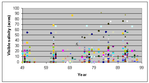
Figure 1. Visible salinity for all sites monitored over 50 years.
When visible salinity was averaged across all sites by soil zone (Figure 2), the largest changes occurred for the Brown and Dark Brown soil zones compared to the Black soil zone for the 70's and 80's. There was little or no change in visible salinity among the three saline types over time (Figure 3).
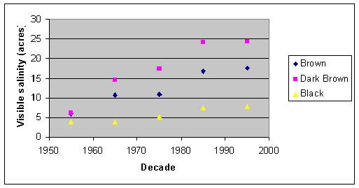
Figure 2. Visible salinity across all sites for each of the soil zones monitored
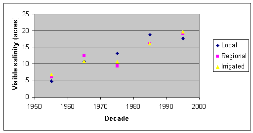
Figure 3. Visible salinity across all sites for each of the three ground water flow systems.
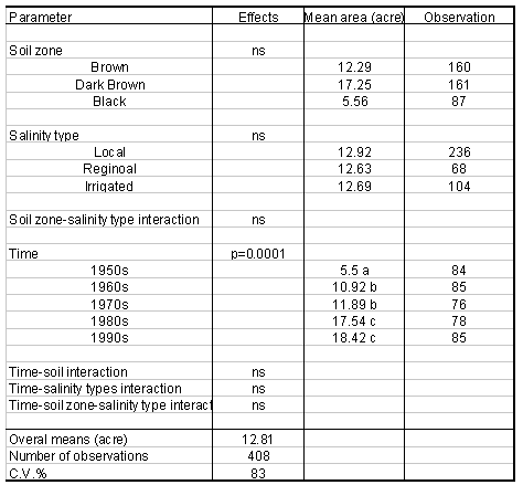
There was no significant effect of soil zone or salinity type on visible salinity for any of the three statistical modeling approaches (Tables 1, 2, and 3). However, time had a significant effect on visible salinity when the split plot model approach was used, but not when the CRD or pooling experiment models were used. The C.V. values were large for this data set varying from 83 to 230%. Data from earlier obs ervations wer e generally ass ociated wit h greater C.V. values than more recent ones T hese high C.V. values result in the st atistical analyses bein g less sensiti ve to change in ar eas of visible salinity.
Table 1. Statistical Analyses Using the CRD Model with Repeated Measures.
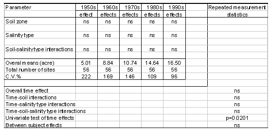
Table 2. Statistical Analyses Using the Pooling Experiment Model with Repeated Measures.
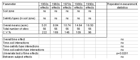
Table 3. Statistical analyses using the split plot model.
Regression analyses indicated that there was a significant linear trend for visible salinity to increase over time (Figure 4). Saline seeps were growing in size. There was a four fold (or 300%) increase in salinity acreage over the 50 years monitored. Saline seep acreage increased on average by 6% per year.
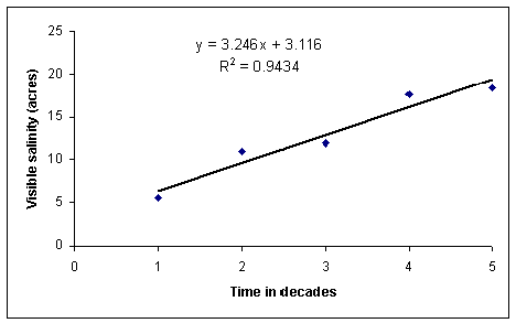
Figure 4. Regression analyses.
Acknowledgements
We wish to acknowledge help from Debbie Werk and Jim Pittman for digitizing the da ta; Dr. Z.Qi Chen for performing statistical analyses; Drs. Tom Maguire, Ron-Cai Yang and Laki Goonewardene for their valuable input and advice on this project.
References
- Alberta Agriculture. 1979. Dryland saline seep control. AGDEX 518-11. 12p.
- Eilers, R.G., W.D. Eilers, W.W. Pettapiece, and G. Lelyk. 1995. Salinization of soil. Pages 77-86 in D.F. Acton and L.J. Gregorich (eds.) The health of our soils-towards sustainable agriculture in Canada. Centre for Land and Biological Resources Research, Research Branch, Agriculture and Agri-Food Canada, Ottawa, Ont.
- Harker, D.B., L.A. Penner, W.R. Harron, R.C. Wood and D. MacDonald. 1996. Dryland Salinity Trends and Indicators on the Prairies. Pages 61-69 in Proceedings of the Soil Quality Assessment for the Prairies Workshop, January 22 to 24, 1996, Edmonton, Alberta.
- Miller, M.R. and L.L. Bahls. 1976. An overview of saline-seep program in Montana. Proc. Reginal Saline Seep Control Symposium, Mont. State Univ. Bulletin 1132, 13-17.
- Prairie Farm Rehabilitation Administration. 1983. Land Degradation and Soil Conservation Issues on the Canadian Prairies. Agriculture Canada. Regina, Saskatachewan. 326 p.
- Rennie, D.A. an d J.G. Ellis. 1978. The shap e of Saskatche wan. Saskatche wan Institute o f Pedolgy, Publication M41, University of Saskatchewan, Saskatoon, Canada.
- SAS Institute. 1998. SAS User’s Guide: Statistics, version 6.12. SAS Institute Inc. Cary, North Carolina.
- Vander Pluym, H.S.A. 1978. Extent , causes and control of dryland saline seepage in the Northern Great Plains of North America. Proceedings of the Meeting of the Sub-Commission on Salt-Affected Soils, 11th International Soil Science Society Congress. Edmonton, Alberta. pp 1-48 to 1-58.
- Wentz, D. and Vanderpluym, H. 1999. Alberta Salinity Project, Final Report. Internal document. Soil Quality Evaluation Project and Canada-Alberta Environmentally Sustainable Agriculture Agreement. Edmonton, Alberta. 44p.
Proceedings of 37th Annual Alberta Soil Science Workshop , February 2 2-24, 20 00, Medicine Hat, Alberta
K. Cannon and D. Wentz
Alberta Agriculture, Food and Rural Development,#206, 7000-113th Street, Edmonton, Alberta T6H 5T6 |
|