| |
Salinity Distribution in the Municipal District of Taber | |
| |
|
|
| |
|
|
| | The M.D. of Taber has 1 643 saline seeps which occupy a total of 12 915 ha (31 901 ac), 3.0% of the M.D.'s total area. The visibly saline areas have such high salinity levels that annual crops cannot be grown and forage crops have significantly reduced yields. Often the lands surrounding the visibly saline areas are also weakly saline, resulting in reduced yields especially for salt-sensitive crops.
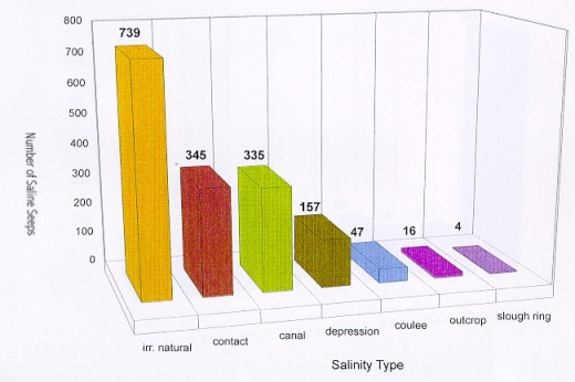
Salinity distribution by type in the M.D. of Taber
| Salinity type | Number of seeps | Area (ha) | Percent of total saline area |
| Contact/slope change | 345 | 1 793.17 | 13.9 |
| Outcrop | 16 | 69.88 | 0.6 |
| Depression bottom | 157 | 3 674.49 | 28.5 |
| Coulee bottom | 47 | 1 397.15 | 10.8 |
| Artesian | -- | -- | -- |
| Slough ring | 4 | 39.83 | 0.3 |
| Irrigation canal seepage | 335 | 2 212.99 | 17.1 |
| Natural/irrigation | 739 | 3 727.96 | 28.8 |
| Total | 1 643 | 12 915.47 | 100 |
Natural/Irrigation salinity occupies the greatest area (28.8% of all saline land in the M.D.), followed by depression bottom salinity (28.5%), irrigation canal seepage salinity (17.1%), contact/slope change (13.9%), coulee bottom salinity (10.8%), outcrop salinity (0.6%), and slough ring salinity (0.3%). There is no evidence that artesian salinity occurs in the M.D.
Number of saline seeps by type in the M.D. of Taber
Salinity type
Please refer to Salinity Classification, Mapping and Management in Alberta for more information. |
|
| |
|
|
| |
For more information about the content of this document, contact Karen Raven.
This document is maintained by Laura Thygesen.
This information published to the web on July 7, 2004.
Last Reviewed/Revised on June 6, 2018.
|
|