| |
Salinity Distribution within the County of Flagstaff | |
| |
|
|
| |
|
|
| | The County has 912 saline seeps which occupy a total of 4 233ha (10 461 ac). The visibly saline areas have such high salinity levels that annual crops cannot be grown and forage crops have significantly reduced yields. Often the lands surrounding the visibly saline areas are also weakly saline, resulting in reduced yields especially for salt-sensitive crops.
No outcrop, artesian, canal seepage or natural/irrigation salinity was identified in the County.
As part of the salinity mapping project, permanent water bodies in the County of Flagstaff were sampled for salinity levels.
In the County of Flagstaff, electrical conductivity was measured in 96 water bodies. Fifty-four permanent or semi-permanent water bodies had readings of 8 dS/m or more; the values range from 8 to 50 dS/m. These water bodies should be avoided for watering cattle.
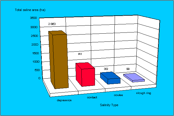
Salinity Type | Number
of Seeps | Area (ha) | Percent (%)
of Total Saline Area |
contact/slope change salinity | 528 | 972.2 | 23.0 |
depression bottom | 283 | 2 860.3 | 67.6 |
coulee bottom salinity | 7 | 302.3 | 7.1 |
slough ring salinity | 94 | 98.6 | 2.3 |
Total | 912 | 4233.4 | 100.00 |
Depression bottom salinity is the most common type (67.6% of the total saline area), followed by contact/slope change salinity (23.0%), coulee bottom salinity (7.1%), and slough ring salinity (2.3%).
Total saline area by type
Please refer to Salinity Classification, Mapping and Management in Alberta for more information. |
|
| |
|
|
| |
For more information about the content of this document, contact Karen Raven.
This document is maintained by Laura Thygesen.
This information published to the web on July 7, 2004.
Last Reviewed/Revised on June 6, 2018.
|
|