| | A catch basin is one method that is used to control surface water runoff from a confined feeding operation (CFO) or manure storage facility. The Agricultural Operation Practices Act (AOPA) states that the construction or expansion of a catch basin for a CFO may require a permit from the Natural Resources Conservation Board (NRCB).
This factsheet provides operators with information for designing, maintaining and managing a catch basin at a CFO. In addition to regulatory requirements, several beneficial management practices (BMPs) have been identified. BMPs can help to further reduce environmental risk or increase safety. Operators must decide if a BMP is to be implemented.
To determine if your operation needs a permit contact the NRCB. Operations not needing a permit should consider meeting or exceeding regulatory requirements as a beneficial management practice. More information is available from the NRCB or through an Alberta Agriculture and Rural Development (ARD) contact listed at the end of this factsheet.
Design
A permitted catch basin must meet minimum design requirements for volume, protective layer or liner, and location as indicated in AOPA.
Catch Basin Volume
Runoff from the CFO is collected in the catch basin. The catch basin volume is calculated using the drainage area, the regional rainfall data and a runoff coefficient. Minimum volume requirements for the catch basin must contain runoff from a one in 30 year probability rainfall event, plus have additional freeboard of not less than 0.5 m. Freeboard is measured from the top of the catch basin to the full service level.
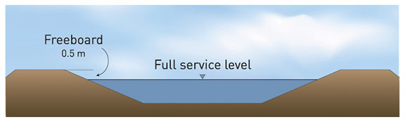
Figure 1. Catch basin filled to capacity
BMP: Operators may want to consider constructing a catch basin larger than required to account for spring snow melt and lessen the frequency of emptying. This will simplify management and reduce the risk of overflow.
The drainage area includes all lands that drain into the catch basin. This includes pens, manure stockpiles, alleyways, handling facilities and any other areas where runoff water flows into the catch basin.
Volume Calculation Example
A CFO operator in Strathmore has a drainage area of 200 m x 300 m (including pens and facilities). A one in 30 year rainfall event in Strathmore will deliver 80 mm of rain over the drainage area.
Based on AOPA the runoff coefficient for an unpaved drainage area with 80 mm rainfall is 0.60. The catch basin volume required can be calculated as follows:
| One day rainfall runoff volume |
 | | = | Drainage Area x one day rainfall x runoff coefficient |
| | = | (200 m x 300 m) x (0.080 m) x (0.60) |
| | = | 2880 m3 |
Regional rainfall data and runoff coefficients can be found in Schedule 2 of the Standards and Administration Regulation of AOPA.
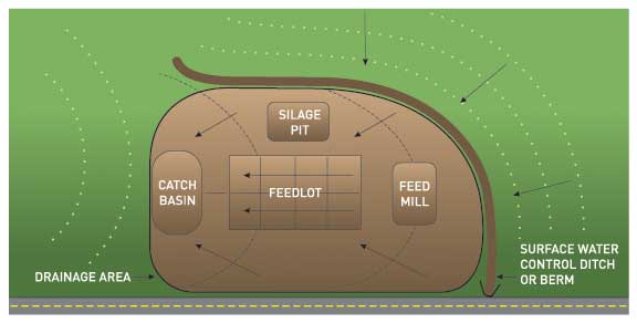
Figure 2. Drainage area of a feedlot with run on and runoff control
Surface Water Control System
It may be necessary to control surface water flowing toward the CFO in order to minimize the amount of water coming in contact with manure. This can be done by diverting upslope water away from the CFO. The diversion should not significantly impact water volume or flow of clean water and should be properly permitted.
Protective Layer or Liner
A catch basin must have a protective barrier to limit infiltration through the bottom of the facility. Either a protective layer or a constructed liner is required.
A protective layer is comprised of natural undisturbed soil which is typically high in clay content. The layer must provide protection that is equal to or better than a hydraulic conductivity of 1 x 10⁻⁶ cm/s and must be at least five metres thick.
A constructed liner is either made of compacted clay, synthetic material or concrete. The liner must provide protection that is equal to or better than compacted soil that is one metre thick and has a hydraulic conductivity of 5 x 10⁻⁷ cm/s.
Additionally, a protective layer or liner must be one metre above the water table at the time of construction and one metre above the uppermost groundwater resource. Technical assistance can determine if the catch basin requires a protective layer or liner.
BMP: All earthen liners should be at least one metre thick as a practical approach to maintain integrity and durability.
Minimum Volume Marker
It is intended that a catch basin is emptied as soon as possible after a rainfall event so that it is ready for the next rainfall event. A marker is required to indicate the minimum volume of the catch basin so that it can accommodate a one in 30 year rainfall event.
Side Slopes
BMP: While not regulated all catch basin side slopes should have a run to rise ratio of 3 to 1, or flatter. This ratio reduces the risk of the sides sloughing in and allows people and equipment to safely access the facility without damaging the liner.
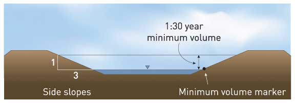
Figure 3. Side slopes and minimum volume marker
If restricted by available area, seek technical assistance for changing slope to increase volume.
Flood Area
A catch basin must be constructed to ensure the top of the facility is at least one metre above the one in 25 year flood level or the highest known flood level.
Location
A catch basin must also meet the minimum distance separation (MDS) from neighbouring residences. Setback distances are based on the animal type and numbers at the CFO or 150 metres, whichever is greater. MDS calculations can be provided by ARD or NRCB staff.
Management
Maintenance
BMP: Periodic visual inspection is an important task for maintaining a catch basin. Problems such as erosion, holes from rodents, or slumping should be repaired as required. Trees should not be allowed to grow near the catch basin to prevent root damage to the liner.
Operation
A catch basin is designed to operate as a temporary storage facility for runoff water. It is necessary to monitor the water level (especially during spring runoff and rainfall events) in order to reduce the risk of overflow. The facility should be emptied to the minimum volume marker or lower as soon as possible. This helps ensure the facility is capable of containing a one in 30 year rainfall when a rainfall event occurs.
Liner Integrity
BMP: Damage to a catch basin liner can occur if it dries out due to soil cracking. To reduce this risk, an operator can maintain a minimum amount of water in the bottom of the facility. This will require the capacity of the catch basin to be greater than the design volume for a one in 30 year rainfall.
Emptying the Facility
Emptying the contents of a catch basin should only be done in a manner that doesn’t create an environmental risk. Options for managing catch basin content can include land application by mobile tanker truck, irrigation or slow flood release with flow rates that ensure infiltration into the soil. Catch basin nutrient content varies widely and can contain nitrogen, phosphorus and sodium. Contents cannot be applied to those crops grown for human consumption which are intended to be eaten raw.
Irrigation
When using the contents of a catch basin for irrigating, it is important to not let the contents leave the property, enter a common body of water or become return flow in an irrigation system.
Slow Flood Release
BMP: When flood releasing catch basin content onto adjacent land, flooding should stop when release water reaches 2/3 the length of the flood area. Further flooding must consider moisture conditions, coordinating additional releases as soil and vegetation allows. Do not allow release waters to leave the property.
Emergency Release
When runoff is expected to exceed catch basin volume during times of extreme moisture conditions, operators should contact the NRCB to determine appropriate action. Proactive action can help to avoid any potential overflow and protect the catch basin from damage.
Safety
BMP: A catch basin is designed to hold water and can be a safety concern. Consider limiting access to humans and animals. If fences are used, the location of the fence should not restrict operation and maintenance of the catch basin.
For more information
(dial 310-0000 to be connected toll free)
Alberta Agriculture and Rural Development
CFO Extension Specialists
Morinville 780-939-1218
Red Deer 403-755-1475
Lethbridge 403-381-5885
www.agric.gov.ab.ca/aopa
Natural Resources Conservation Board
Field Offices
Fairview 780-835-7111
Morinville 780-939-1212
Red Deer 403-340-5241
Lethbridge 403-381-5166
www.nrcb.gov.ab.ca |
|