| | Climate regions | Farm climate | Microclimate
This document is part of the Agroclimatic Atlas of Alberta.
Alberta has a continental climate with warm summers and cold winters. The agricultural area of the province (shown on Figure 1) has a semiarid climate because the annual precipitation is less than the water evaporated by the wind and heat, and transpired by plants.
The distribution of temperature and precipitation in Alberta results mainly from the shifting boundary between air masses. The most common air masses are the maritime polar, continental polar, maritime tropical, and continental arctic. Usually only two of these air masses will be found over the province at a given time. As the fronts between the air masses shift north and south across Alberta, temperature can change rapidly. The boundary between the two air masses will often be in the extreme north of the province in the summer and across the central part of the province in the winter.
Temperatures are generally higher in southern than northern Alberta because the south receives more solar radiation (Figure 2 and map of Annual Total Global Solar Radiation). In July, the average daily temperature ranges from warmer than 18�C in the south to cooler than 13�C in the Rocky Mountains and the north (July Daily Mean Temperature Map). In January, the average daily temperature ranges from cooler than -24�C in the far north to warmer than -10�C in the south and the mountains (January Daily Mean Temperature Map). The warming effect of the chinook winds near the mountains produces a west to east trend in winter temperatures. The range of average temperatures across the province in winter is greater than in summer because of the reduced heating from the sun at northern latitudes.
Arctic air masses in the winter produce extreme minimum temperatures varying from cooler than -54�C in northern Alberta to warmer than -46�C in southern Alberta (Extreme Minimum Temperature: 1901 to 2000 Map). In the summer, continental air masses produce maximum temperatures from 32�C in the mountains to warmer than 40�C in southern Alberta (Extreme Maximum Temperature: 1901 to 2000 Map). These air masses can move quickly in the spring and fall resulting in rapid seasonal changes.
Precipitation is generally highest along the mountains and into west central Alberta due to the combined effects of frontal and topographic precipitation (Annual Total Precipitation Map). Precipitation from May 1 to August 31 varies from slightly below 200 millimetres (mm) in the driest prairie areas to more than 325 mm in the mountains (May 1 to August 31 Total Precipitation Map). From September 1 to April 30, precipitation ranges from less than 150 mm in the driest prairie region to more than 275 mm in the mountains (September 1 to April 30 Total Precipitation Map).
Alberta is a sunny province. Annual bright sunshine totals range between 1900 and 2500 hours per year. Northern Alberta receives about 18 hours of daylight in the summer. The long summer days make summer the sunniest season of the year in Alberta.
Climate Regions
In general, climate regions can be represented by ecoregions (Figure 4). An ecoregion is an area of similar climate, physiography, vegetation, soil, water, fauna and land use characteristics. Climate strongly influences many of the other characteristics in an ecoregion, such as soils, vegetation, water, fauna and land use.
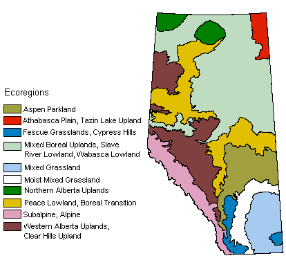
Figure 4. Ecoregions of Alberta
In the agricultural area of Alberta, the Mixed Grasslands in southeastern Alberta have the lowest precipitation and hottest summers. Moving west and north through the Moist Mixed Grasslands, Aspen Parkland, Boreal Transition and Western Alberta Uplands, the climate becomes moister and cooler. The Peace River Region (see Figure 1) is an exception, with relatively warm summer temperatures and low precipitation for its latitude. The long summer day length in the Peace River Region improves the agricultural potential of this area.
For more information on Alberta’s ecoregions, see Soils and Ecoregions in Alberta.
Farm Climate
The climate on any farm or any field may differ from that of the area around it. Factors such as local variations in elevation and farm management practices influence farm climate.
The local topography has a marked effect on the incidence of frost. After sunset, the ground cools rapidly. The layer of air immediately above the ground cools, becomes heavier and tends to drain down the land slope and collect in depressions and hollows. In these frost pockets, this cold air drainage results in much earlier frosts in the fall and later frosts in the spring than found in surrounding areas. Hillsides on average have longer frost-free periods than lower areas and valleys. Conditions for cold air drainage exist when there is no general air movement. Even a light wind will mix the thin, cold surface layer of air with the relatively warm air above it. Moderate winds will quickly equalize the temperatures.
South- and west-facing slopes receive more direct radiation from the sun and tend to be warmer and drier than east- and north-facing slopes. These effects can be either positive or negative depending on crop type and precipitation.
Farm management may affect temperature and moisture conditions. For example, maintaining a crop residue cover to catch snow can increase soil moisture but may also slightly reduce surface soil temperature in the spring. The residue cover intercepts some heat, and wet soil warms up more slowly than dry soil. However, the added moisture for crop growth and the protection from soil erosion (removal of soil particles by wind or water) provided by the residue cover more than compensate for the slight decrease in spring soil temperatures. Soil erosion results in lower soil productivity and can also harm water quality and air quality.
Microclimate
Microclimate is the climate of any small area. Microclimates can exhibit conditions that are distinct from the surrounding area. The characteristics of the soil surface, such as whether it is bare or covered with plants, have a great influence on the microclimate. A sheltered area has a different microclimate than an open field. Generally, warmer daytime temperatures are found in river valleys. Two examples are along the Peace River at Dunvegan and at the town of Peace River where vegetables thrive. Cooler temperatures are found at higher elevations, such as the tops of the Cypress and Hand Hills (see Figure 1). |
|