| | Frontal precipitation | Convective precipitation | Topographic precipitation | Chinook winds | Severe weather | Extreme weather | Weather lore
This document is part of the Agroclimatic Atlas of Alberta.
Weather in Alberta is produced by the interaction of air masses with different temperature and moisture characteristics. The properties of these air masses vary with the season, with whether the air mass was formed over land or sea, and with the latitude of the air mass's area of formation.
In the winter, Alberta's weather is dominated by the maritime polar and the continental polar air masses. The maritime polar air mass from the north Pacific is moist, providing moisture for snow in the mountains and to a lesser extent over the prairies. The continental polar mass, formed over Canada's interior, is dry and cold. Occasionally the continental arctic air mass advances into Alberta from the far north, creating intense cold weather.
In the summer, Alberta's weather continues to be dominated by the maritime and continental polar air masses, but maritime tropical air masses from the Gulf of Mexico and from the Pacific sometimes enter Alberta, often bringing significant moisture.
Air masses and their cold and warm fronts account for the daily precipitation and temperature conditions under which agricultural managers operate.
Frontal Precipitation
The boundary between air masses with different properties is called a front. A cold front occurs when cold air advances towards warm air. It pushes under the warm air, causing it to rise, cool and create precipitation. A warm front occurs when warm air overrides cold air, which can also result in precipitation.
In general, warm fronts generate more precipitation over a larger region than do cold fronts. The passage of a cold front is more likely to produce severe weather events, including heavy rain, hail and tornadoes, than the passage of a warm front.
The greatest precipitation amounts occur in Alberta when moist air finds its way into the province from either the Gulf of Mexico or the Pacific Ocean off California. This usually happens when a large low pressure system moves toward Alberta from the south.
Storm systems are always low pressure systems. Low pressure systems have central barometric pressures lower than their surroundings. High pressure systems have central barometric pressures higher than their surroundings. The circulation or motion around a low pressure system is counterclockwise in the northern hemisphere, clockwise in the southern hemisphere and undefined at the equator. The circulation around a high pressure system is the opposite of that around a low pressure system.
Convective Precipitation
Convective precipitation occurs when the air near the ground is heated by the earth’s warm surface. This warm air rises, cools and creates precipitation. The moisture sources for convective storms are the moisture contained in the air mass and the moisture evaporated from the earth's surface and transpired by vegetation.
Convective storms or showers account for about 40 per cent of summer rainfall. The amount of rain produced by any shower can vary greatly. Sometimes the rain evaporates before it reaches the ground; at other times rainfall amounts are substantial, as in the case of thunderstorms. The rainfall amount and intensity can vary greatly over short distances. Heavy showers can produce significant runoff, which can result in serious water erosion (the removal of soil particles by water).
Topographic Precipitation
Topography can play a role in creating precipitation. Air is lifted when it passes over rising ground. As the air rises, it cools and, if it rises sufficiently and contains enough water, precipitation will occur. Topographic effects can increase the amount of precipitation received from frontal or convective storms. For example, the Milk River Ridge, Hand Hills and Clear Hills have higher precipitation than surrounding areas (see Figure 1).
In southern Alberta, moist air masses from the Gulf of Mexico push up against the foothills of the Rocky Mountains. The rising land adds topographic effects to the frontal rainfall, leading to major widespread rain in the foothills and western prairies. The moist, southeasterly winds and increasing elevation can also create ground fogs several thousand metres deep in southwestern Alberta. This form of weather is so common at Lethbridge that the instrument landing system at the Lethbridge Airport is designed primarily to deal with it.
Chinook Winds
Chinooks are warm, dry winds that descend on the eastern side of the Rocky Mountains, primarily in Alberta and Montana. The term "chinook" is derived from the name of a First Nations tribe living along the Columbia River (from the Salishan word "Tsinuk"). The term was originally used to refer to a wind that blew from the direction of the tribe's encampment.
Chinook winds often have a distinctive arch cloud with a sharp western edge that runs parallel to the Rocky Mountains. A chinook arch can stretch for a few hundred kilometres. The shape of the arch is due to both the cloud height and the large cross-wind extent along the horizon.
The process for creating a chinook begins as warm, moist air from the Pacific Ocean moves over the three mountain ranges in British Columbia. As the air climbs up the western side of each mountain range, it cools. Warm, moist air cools at a rate of 0.5 to 0.8°C for every 100-metre (m) rise in elevation, depending on the amount of moisture available. The cool, moist air forms clouds and fog, and some of the moisture in the air falls as rain or snow. As the air descends on the leeward side of the mountain range, the air heats up. Dry air heats up faster than wet air, warming at the rate of about 1°C for each drop of 100 m.
Each time the air rises over another mountain range, it loses more moisture, and each time the air descends, it becomes warmer. The process of wet air cooling and dry air warming over the mountains is called the orographic effect. By the time the air descends on the eastern side of the Rocky Mountains, it is much warmer and drier.
The conditions required for a chinook to occur include a high pressure weather system in western British Columbia and a low pressure weather system in the lee of the Rocky Mountains. The strength of the chinook depends on the moisture content of the air that flows between the high and low pressure systems, the pressure differences between the two systems and the topography of the affected area.
The atmospheric processes that produce a chinook occur year-round, but the effects are most pronounced during the winter when temperature increases of 25°C or more within a few hours are possible. The chinook effect is most significant in southwestern Alberta, where these winds frequently remove the snow cover. Farther from the mountains, the effect is usually less dramatic as the air temperature near the ground may rise by only a few degrees.
Figure 3 shows the chinook zone of Alberta based on a definition developed by Longley (1972). He defined the chinook zone as the area with 20 or more days of maximum temperatures greater than of 5°C during December, January and February.
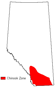
Figure 3. Chinook zone of Alberta
The strong, gusty chinook wind can be unpleasant, and can result in physiological and psychological reactions in humans such as headaches and increased irritability. Chinooks can have positive or negative effects for agriculture. For example, the high evaporation can increase plant water stress in areas already suffering from low precipitation, while the reduced snow cover can lengthen the grazing season and decrease the amount of stored feed required.
Severe Weather
Severe weather is any destructive storm, but the term is usually used for intense local storms. Examples include hail storms, heavy rains, gusty winds, high winds and tornadoes. In general, severe weather events have a great effect but the effect is concentrated in a small area.
Severe weather events occur in Alberta and can cause significant problems for agriculture. In the case of heavy rain, the risks to agriculture may occur at some distance from the storm itself because heavy rains in high areas can produce downstream flooding.
Efforts are currently underway to improve prediction and provide advance warning of severe weather so people can take measures to prevent loss of life and property. Insurance (general and crop) provides a way to reduce the economic impact from these kinds of losses.
Extreme Weather
Extreme weather is weather that occurs outside of the normal range of weather intensity for a location. It is infrequent or rare and can produce a damaging impact, although not all extreme weather events end in disasters. An extreme weather event becomes a disaster when the resulting damage is beyond the capacity of a community or system, such as an agricultural production system, to cope.
Extreme weather can create significant problems for agriculture. Examples of extreme weather include heat waves, cold spells, dust storms, prolonged dry periods and prolonged wet periods and summer snowstorms.
Some extreme events occur because of a combination of factors. For instance, the merging of two weather systems, the occurrence of a severe weather event combined with another factor, or consecutive years of very low precipitation can lead to an intense impact.
While drought is a natural and repeating occurrence on the prairies, when serious droughts occur in consecutive years, they are considered climate extremes. The 2001 drought, for example, was a disaster for Alberta producers, costing the province’s economy billions of dollars. In 2002, the impact of the drought intensified as a result of the record low precipitation levels in the central and Peace regions of Alberta. The multi-year droughts combined with a record number of days above 30°C, and an outbreak of grasshoppers made 2002 even worse for agriculture in many parts of Alberta.
Protection against extreme events can be planned in some cases but not in others. With stock watering supplies, it is possible to estimate requirements and construct adequate water storage to reduce the risk of shortage, but at a cost. In dryland farming, reduced and zero tillage systems are used to conserve soil moisture in the event of inadequate rainfall; however, even under these tillage systems, crops will be affected by prolonged drought. Insurance plans, such as crop or forage insurance, are an important way to reduce the financial risks and consequences of extreme weather.
Weather Lore
Weather lore is based on both fact and fiction. It is often passed on from generation to generation even if circumstances have changed. The lore is often contained in a catchy rhyme such as:
"An evening grey and morning red will send a shepherd wet to bed." |
This statement tested for London, England proved right 70 per cent of the time. This piece of lore has a sound scientific basis. Weather systems approach from the west and are often preceded first by high thin cloud, then increasingly thick clouds at lower altitudes. This accounts for the grey at sunset. In the morning, the long path the sunlight takes through the atmosphere, indicating no clouds to the east, causes the red at sunrise. The normal dusty atmosphere allows the sun's red rays to pass through to a greater extent than the blue rays, making the sky appear red.
Generally weather and climate lore must be applied in the environment for which it was developed. For example, in southwestern Alberta, the presence of a chinook arch usually results in warm and windy conditions. A similar looking cloud seen elsewhere will not foretell this event.
Some weather lore is linked with recurring events that have general applications. Over 2000 years ago, the Greeks recognized that sun haloes (sun dogs) foretold rain. Modern day studies confirm that this is generally a valid prediction. Sun dogs are produced by small ice crystals in the atmosphere. These crystals increase as an air mass becomes wetter. When sunlight strikes the ice crystals, the crystals break up the light into its component colours in the way that a prism does.
Some lore is based on plant and animal activities, such as Groundhog Day. Although such lore has been severely criticized in the past, these sayings have recently gained some credibility because many creatures are much more sensitive to slight changes in temperature, pressure and humidity than humans are, and their reactions can provide some indications of a change in weather.
Some reservations should be kept in mind when applying lore. Lore is usually based on what is best remembered rather than what normally happens; violent or rare events often stick in the observer's mind more than routine events. Also weather lore is often based on regional conditions. These conditions may not apply to individual locations, especially with respect to weather elements like frost that are strongly affected by the local characteristics.
Linked with lore, there are recurring events such as "Indian Summer", "in like a lion, out like a lamb" (the March forecast), "Groundhog Day", and the "Bonspiel Thaw". These do not always happen but occur with sufficient frequency to be accepted as more than the result of chance. |
|