| | Use this link to return to the CAESA Soil Inventory Procedures Manual
The objective of the project was to compile the soil landscapes of the White Area (Figure 1.1) of Alberta at a presentation scale of 1:100 000, linked to a digital database of soil information.�
The CAESA Technical Steering Committee consisting of representatives of the three contributing agencies, one from Olds College and one from PFRA oversaw the Soil Inventory Project. The Technical Steering Committee provided a terms of reference for the project and defined the overall project goals as:�
1. To produce a standardized digital database of soils information for the agricultural portion of Alberta (White Area) through review and recompilation of all relevant soils and ancillary data.�
2. To develop a methodology for producing standardized descriptions of Soil Landscape Models and to apply the models uniformly and consistently across the entire White Area.�
3. To ensure that the digital soils data was registered to the 1:20 000 provincial digital base.�
This document represents one of the steps toward realizing the goals set by the Technical Steering Committee. Since the main objective of the project was to produce a standardized soil information database for the entire White Area of Alberta (Figure 1.1), there was a clear set of specifications for the content of the soil information database and of the procedures by which this information was compiled.�
Introduction to this manual
This manual describes the procedures used for soil mapping and attribute coding for the CAESA project. It also provides users of the database some background information on the mapping systems used during the compilation of the soils database. This manual served two main functions. The primary function was to control the inventory process through the use of standard mapping procedures and attribute codes. The secondary function was to provide an understanding of the inventory approach and process, and of information produced by the CAESA Soil Inventory Project.�
�� 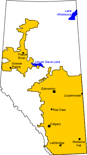
Figure 1.1 White Area (agricultural portion) of Alberta.�
Introduction to the soil inventory approach being used
A soil inventory usually involves description, sampling and classification of the soils of an area; and the production of a soil map. Soil inventory methods and philosophies have changed considerably over the 75 years that soil surveys have been conducted in Alberta. A number of key references describing soil inventory concepts and procedures are listed in Appendix A.�
Several studies were completed prior to the initiation of the CAESA Soil Inventory Project. The objectives of these studies were to evaluate and compare alternative methods of soil mapping in terms of map accuracy, cartometrics, time requirements and cost (Nikiforuk, MacMillan and Fawcett 1993; Fawcett, Nikiforuk, McNeil and MacMillan 1993; Nikiforuk and Howitt 1993). These studies provided necessary background information for the CAESA SI project.�
Soil inventories are done at several levels of detail (inventory scale), ranging from general overviews of large areas to very detailed inventories of small areas (Figure 1.2). The framework of ecological land stratification at several levels of detail is described in Section 2.1. This manual focuses on two levels of soil inventory:�
a)� Land Systems (1:250 000 scale), and�
b)� Soil Landscapes (1:100 000 scale).�
The approach described in this manual is a defined, documented and standardized approach that inventory personnel could duplicate.�
The CAESA Soil Inventory Project retained many traditional concepts and procedures. Some of the differences addressed the specific information needs of potential users. The differences from traditional Alberta Soil Survey procedures and information products included:�
a)� the products are digital;�
b)� the user can request or produce maps with customized (user-defined) labels and map legend information;�
c)� there are two levels of inventory - Land System inventory (1:250 000 scale), and Soil Landscapes inventory (1:100 000 scale); and�
d)� several soil and land attributes were collected. The digital environment allowed the soil inventory analyst to attach a list of attribute codes to areas thereby permitting customized output products.�
��
Some of the key traditions that were retained include:�
a)� the established practice of using the soil series names as a key to a list of soil attributes. In fact, the correlation and definition of series names were improved during the project, and�
b)� the established concept of Soil Landscape Models (called Soil Map Units in earlier reports) used by soil inventory analysts as one of the attributes of a Soil Landscape. This attribute can be used to generate a label on a soil map product (user's option) or it can be used in tabular reports.
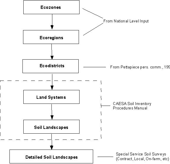
Figure 1.2 The Hierarchical System of Land Stratification |
|