| | Problem | Literature review | Study description | Major findings | Applied questions | References
Problem
Questions about changes in the quality of soils arose in the 1980s along with the concept of sustainable agriculture. Data sets with which to make such judgments were not available or adequate for many areas. Agriculture and Agri-Food Canada established a national network of benchmark sites that represent major agro-ecoregions, soil landscapes, and agricultural production systems. These serve as reference landscapes for monitoring soil quality change over time. This approach assumes that monitoring selected soil variables for 10 years or more will show changes in soil conditions.
Literature Review
A report by the Standing Senate Committee on Agriculture, Fisheries and Forestry6 examined the problem of soil degradation. At issue were natural processes such as water and wind erosion, loss of structure, salinization, and others that were being accelerated by agricultural practices such as intensive tillage, chemical applications and summerfallowing. In the Prairie region, wind and water erosion, and salinization were considered the most significant2. The Senate report estimated that soil degradation cost Canadian farmers one billion dollars in 1984 alone.
At workshops in eastern (1988) and western (1990) Canada, agrologists addressed the soil degradation issue and agreed that a soil quality monitoring system was needed8,9. Most believed that creating a network of benchmark sites would be an effective way to collect baseline data and monitor soil quality.
Guidelines as to the site selection, sampling design and measurement techniques also had to be worked out at the workshops. Examples of methodology for establishing benchmark sites were scarce prior to 1989. The French proposed a monitoring network with many 1-ha sites3. In the United States, thousands of sites identified by soil type, slope and land use were monitored by applying the Universal Soil Loss Equation (USLE) to estimate rates of soil erosion (D. Arnold, pers. comm., 1989).
With limited resources, selection of representative sites within major agricultural regions was crucial. Pilot sites were established in eastern Canada in 1989. With National Soil Conservation Program funding from 1990 to 19921, the network was expanded to 23 sites across the country. CAESA continued to support the benchmark site monitoring effort in Alberta from 1992 to 1997.
Study Description
Twenty-three benchmark sites were established across Canada from 1989 to 1992. Ten of these are located in the Prairie provinces (Figure 1). The 10 Prairie sites represent a combination of six soil zones or subzones, six ecoregions, and nine physiographic districts (Table 1). Four of the 10 sites are located in Alberta at Falher (03), Mundare (04), Provost (05), and Bow Island (06).
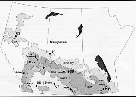
Figure 1. Ten benchmark sites are located in the agricultural parts of the Prairie provinces
Techniques to measure and monitor selected soil parameters in different landscapes at a farm-field scale were developed early in the project9. The methods had to be appropriate for the different regions and landscapes, and achievable with limited resources, including time.
Commonly, each site was characterized by detailed soil and topographic maps and an agronomic history. Topsoil and some subsoil samples were collected on either a grid (low relief) or a transect (high relief) sampling design. At least two profiles representing the dominant soil types were also sampled.
Table 1. Selected features of the 10 benchmark sites located on the Prairies (Alberta sites in italics)
Soils and ecoregion | Physiography | Site and location | Management system |
| Gray (Luvisolic) soils; Boreal Transition | Beaver River Plain | 10 - Loon Lake, SK (established 1991) | Barley - oilseed; conventional tillage |
| Dark Gray soils; Peace Lowland | Falher Plain | 03 - Falher, AB (established 1991) | Cereals - canola - forage; conventional tillage |
| Black soils; Aspen Parkland | Whitford Plain | 04 - Mundare, AB (established 1992) | Peas - barley - canola - wheat; conventional vs direct seeding |
| Black soils (thin); Aspen Parkland | Quill Lake Plain | 09 - Lanigan, SK (established 1990) | Extended rotation (continuous cereal); conventional tillage |
| Black soils; Lake Manitoba Plain | Red River Valley | 12 - Carman, MB (established 1990) | Wheat - canola; minimum tillage |
| Humic Gleysols; Lake Manitoba Plain | Red River Valley | 11 - Brunkild, MB (established 1991) | Continuous cereals; zero tillage |
| Dark Brown soils; Aspen Parkland | Provost Upland | 05 - Provost, AB (established 1990) | Canola - wheat - fallow; conventional tillage |
| Dark Brown soils; Moist Mixed Grassland | Assiniboine River Plain | 08 - Regina, SK (established 1991) | Extended rotation, mainly wheat; conventional tillage |
| Brown soils; Mixed Grassland | Cypress Hills Upland | 07 - Swift Current, SK (established 1992) | Wheat - fallow; conventional tillage |
| Brown soils; Mixed Grassland | Etzikom Plain | 06 - Bow Island, AB (established 1991) | Canola - wheat - beans; irrigated conventional tillage |
Total carbon (C), inorganic C (CaCO3 equivalent), total nitrogen (N), exchangeable cations and cation exchange capacity, pH (CaCl2), available P and K, cesium-137 content, electrical conductivity and soluble salts, particle size distribution, aggregate size distribution, clay mineralogy, surface area, and total elements were determined on all or a portion of the samples. Saturated hydraulic conductivity (Ksat) by the Guelph Permeameter, penetrometer readings with moisture content, and EM38 readings of electrical conductivity (for salinity assessments) were measured in the field. As appropriate, other features may be monitored at specific sites, for example NO3 and salt levels deep in the soil under irrigation. Site description reports outline the specific methods used at individual sites4,5,7.
Normally, the soil sampling will be repeated at about five-year intervals, preferably at the same stage in the rotation as the baseline sampling. Only those analyses that might change in that interval would be conducted9. Field measurements are performed for two to three years around the sampling intervals at most sites, annually at a few sites. Management activities, crop yields and climatic data are gathered on an ongoing basis.
Work continues towards the main objective - monitoring temporal change in soil characteristics at the benchmark sites. In the west, this is about half way through the proposed 10- to 12-year timeline. Six of the 11 western sites (including 01-BC near Chilliwack on the Fraser Valley Lowland) were re-sampled for the first time in 1995 and 1996. One site (05-AB) was re-sampled twice, three (1993) and six (1996) years after it was established. Another site (09-SK) was re-sampled in 1993, three years after it was established. Three sites, two in Alberta and one in Saskatchewan, will be re-sampled in 1997.
Major Findings
With the baseline, repeat and monitoring activities, massive amounts of data are being collected and archived in a simple database developed for the study. So far, there is insufficient data to examine the long-term trends in soil quality. However, several ancillary studies were spawned, through examination of the available data and through opportunity. Ancillary studies involving the Alberta benchmark sites include:
- comparison of cultivated and native sites at Provost (05) to assess changes brought about by 80 years of cultivation (see Factsheet on the effects of long-term cultivation);
- examination of soil-landscape relationships in the four different Alberta landscapes which range from level and uniform to complex and hilly (see Factsheet on soil variability in morainal landscapes);
- comparison of direct seeded and conventional tillage management systems to evaluate the effects on soil quality change at the Mundare (04) site; and
- use of Plant Root Simulator probes (PRS-probe) to determine nutrient supply rate as a measure of a soil's quality at the Mundare (04) site and two others across Canada.
Applied Questions
What is the value of monitoring soil quality?
Agronomists and soil scientists have long presumed that traditional practices of intensive cultivation were, for the most part, detrimental to soil quality. In many regions, there was little quantitative information to back up this notion, except for selected "problem" soils and at some research stations. Being able to estimate rates of change, where measurable, would be a useful tool in the movement towards more sustainable agricultural practices.
For example, preliminary results from this study are raising concerns about the rate of change at one Prairie site, which has a representative soil-landscape pattern. The data show a small (and statistically insignificant) decline in soil organic carbon (C) of the plow layer at all slope positions after just three years.
If this trend holds with continued monitoring, the ramifications are ominous. The "life expectancy" of this soil resource could be calculated, assuming the oilseed-grain-fallow production system would not change. Accordingly, production systems that include traditional cultivation with frequent fallow would be judged not sustainable.
Can changes in soil properties be detected by monitoring them over a 10-year interval at a benchmark site?
Preliminary data for organic C at two western sites show interesting trends after just three years, but the differences are not statistically significant. More questions are raised. Will the trends continue or was the difference merely "noise" related to sample variability? Data from subsequent sampling intervals should clarify the picture. Likely, changes in many attributes at the western sites will be of similar magnitude - some detectable, some not detectable in the time allotted for the study. In eastern Canada at the 20-NB site, significant changes in topsoil organic C were found after only three years. Organic C had been redistributed in the rolling landscape that is managed under an intensive potato - grain rotation.
References
- Acton, D.F. 1989. The development of a soil quality evaluation system for assessing agricultural sustainability in Canada - A research proposal. Land Resource Research Centre, Research Branch, Agriculture Canada, Ottawa, ON. 42 pp.
- Coote, D.R., Dumanski, J. and Ramsey, J.F. 1981. An assessment of the degradation of agricultural lands in Canada. Land Resource Research Institute, Research Branch, Agriculture Canada, Ottawa, ON. 86 pp.
- Lavelle, P. 1988. Parametres biologiques a mesurer dans le cadre de l'observatoire de la qualit� des sols. Rapport interm�diaire Novembre, 1988. Secr�tariat D'�tat A L'environnement.
- Michalyna, W., Walker, B.D. and Wang, C. 1995. Benchmark site documentation: 12-MB (Carman, Manitoba). Centre for Land and Biological Resources Research, Agriculture and Agri-Food Canada, Winnipeg, MB. CLBRR Contrib. No. 95-64. 20 pp.
- Rees, H.W. and Wang, C. 1993. Benchmark site documentation: 20-NB. Centre for Land and Biological Resources Research, Agriculture and Agri-Food Canada, Ottawa, ON. 26 pp.
- Sparrow, H.O. 1984. Soil at risk. A report on soil conservation by the Standing Committee on Agriculture, Fisheries and Forestry to the Senate of Canada, Ottawa, ON. 129 pp.
- Walker, B.D. and Wang, C. 1994. Benchmark site documentation: 05-AB (Provost, Alberta). Centre for Land and Biological Resources Research, Agriculture and Agri-Food Canada, Edmonton, AB. CLBRR Contrib. No. 95-03. 22 pp.
- Wang, C., Gregorich, L.J., Rees, H.W., Walker, B.D., Holmstrom, D.A., Kenney, E.A., King, D.J., Kozak, L.M., Michalyna, W., Nolin, M.C., Webb, K.T. and Woodrow, E.F. 1995. Benchmark sites for monitoring agricultural soil quality. Pages 31-40 in D.F. Acton and L.J Gregorich (eds.), The health of our soils: toward sustainable agriculture in Canada. Centre for Land and Biological Resources Research, Agriculture and Agri-Food Canada, Ottawa, ON.
- Wang, C., Walker, B.D., Rees, H.W., Kozak, L.M., Nolin, M.C., Michalyna, W., Webb, K.T., Holmstrom, D.A., King, D., Kenney, E.A. and Woodrow, E.F. 1994. Benchmark sites for monitoring agricultural soil quality in Canada. Soil Quality Evaluation Program Technical Report 1, Centre for Land and Biological Resources Research, Agriculture and Agri-Food Canada, Ottawa, ON. 76 pp.
Return to CAESA Soil Quality Program Research Factsheets
This information is provided by B.D. Walker, C. Wang and H.W. Rees of Agriculture and Agri-Food Canada. |
|