| | General approach | Pilot areas | Soil-landform (SL) units | EPIC analysis | Land suitability (LSRS) analysis
General Approach
The one specified condition in the objectives was that the analysis should be done on an "Agroecological Resource Area" (ARA) (Pettapiece 1989) or similar basis. In the interim, a national federal-provincial initiative to develop a coordinated ecological framework for Canada was completed (ESWG 1995). This work incorporated the ARA concept at the Ecodistrict level. As the two units were practically identical, the decision was taken to use the nationally coordinated Ecodistrict as the unit for analysis. There are about 75 agricultural ecodistricts in Alberta so a number of pilot areas were selected for developing and testing procedures.
A preliminary review of the potential models and soil quality assessment tools was discussed with the study steering committee. The first decision was that existing tools should be used in this study. With that caveat, the Land Suitability Rating System (LSRS) (Pettapiece 1995) was selected to provide a basic assessment or index of soil quality. The Erosion Productivity Impact Calculator (Williams et al. 1990) model (EPIC) was chosen to assess the impact of present farming practices. The trend would be the difference between the initial LSRS soil rating and a rating using the EPIC predicted changes in soil properties as LSRS inputs. Thus for any Ecodistrict:
Initial soil quality = LSRS (to)
Predicted trend in soil quality = LSRS(tn) - LSRS(to)
where:
LSRS(to) is Land Suitability Rating at time zero
LSRS(tn) is Land Suitability Rating based on EPIC predictions of soil parameter change for a specified period of time (tn)
Pilot Areas
The criteria for selection of Ecodistricts to be used as pilot areas were that they:
- should be a typical representative for each major ecological (climatic) zone,
- should represent each major land use,
- should represent a range of soil conditions in each region,
- should contain at least 5 SLC polygons, and
- should aim for a minimum of 3 from each ecological zone.
Using the above criteria, 15 Ecodistricts were selected (Table 1, Figure 1).
Table 1. Pilot Ecodistricts selected for the study
Ecodistrict | Description /Comment | SLC |
No. | Name | Ecol | Ag-cl | Soil | comments | No. | typical |
| 593 | Rycroft | LB | 2-3H | Bl - Gr | mix | 10 | 480077 |
| 596 | Dunvegan | LB | 2-3H | Gr,DkGr | mix, sands, hummocky | 11 | 480069 |
| 598 | Beaverlodge | LB | 3H | DkGr | mix, grasses | 4 | 480019 |
| 680 | Beaver River | LB | 3H | Gr,DkGr | mix | 11 | 480302 |
| 681 | Westlock | LB | 3H | DkGr | mix | 8 | 480196 |
| 727 | Leduc | Gt | 2H | Bl | mix, variable | 24 | 480431 |
| 728 | Andrew | Gt | 2H | Bl | mix (BM site) | 5 | 480728 |
| 730 | Vermilion | Gt | 2H(A) | Bl | mix, hilly, variable | 18 | 480360 |
| 746 | Olds | Gt | 3H | Bl | barley | 6 | 480557 |
| 743 | Provost | GtGa | 2AH | DkBr | mix(wheat), (BM site) | 2 | 480423 |
| 781 | Drumheller | Ga | 2AH | DkBr | mix, clays | 5 | 480584 |
| 793 | Lethbridge | Ga | 2A | DkBr | wheat-fallow, mix, var. | 10 | 480657 |
| 806 | Berry Creek | Ga | 3A | Br-Sz | wheat-fallow, grazing | 7 | 480487 |
| 821 | Schuler | Ga | 3A | Br | wheat-fallow, graz, hilly | 5 | 480598 |
| 828 | Foremost | Ga | 3A | Br | wheat-fallow | 14 | 480642 |
* ecol: Ecological Region (LB = Low Boreal, Gt = Parkland(transitional Grassland), Ga = Grassland
| ag-cl: | agricultural climate (3H = moderate heat limitation, 2H = slight heat limitation, 2A = slight moisture limitation, 3A = moderate moisture limitation) |
 | |
| soil: | Soil zone (Gr = Grey, DkGr = Dark Grey, Bl = Black, DkBr = Dark Brown, Br= Brown, Sz = Solonetzic) |
| |
| comments: | crops (mix = no crop dominates), soil texture if other than loamy, landform if hummocky, "BM site" = national benchmark site |
| |
| SLC: | Soil Landscapes of Canada; No. = number of units in the Ecodistrict, typical= unit used for the climate link. |
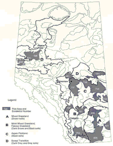
Figure 1. Pilot Ecodistricts used for sustainability analysis.
Soil-Landform (SL) Units
Natural resource or ecological units are commonly described in terms of features or components from the next more detailed level in the hierarchy (Pettapiece, internal document on scaling and extrapolation). Following this suggestion, Ecodistricts, at a scale of about 1:2 M, were described in terms of features significant from the Soil Landscapes of Canada (SLC) (version 2) or 1:1 M level. It was further decided that soil-landform combinations should be the basic land units.
As noted in Table 1, each Ecodistrict is comprised of a number of SLC units. In turn each of these will commonly identify about 3 soil-landform (SL) components. Some of the components occur in more than one SLC, the SLCs are of different sizes and some of the SL components are not cultivated. The following procedure was completed to determine the most appropriate SL combinations to represent the Ecodistrict.
1. SLC polygons linked to the Ecodistrict were accessed using soil name, slope, proportion, and SLC area. The areas of each soil/slope combination in each district was calculated based upon these factors.
2. The resulting list of soil/slope combinations was reviewed to remove noncultivated soil units, including:
- miscellaneous land units such as river valleys (ZRB, ZAV),
- wet soils (Gleysols, Organics, ZGL, ZOR),
- very sandy soils (LS and S; Regosols), and
- units with slopes >15% (D, E, F).
- The remaining soil/slope combinations were grouped into generally similar response classes based upon:
- surface percent organic carbon ( < 1.5, 1.5-3.0, > 3.0),
- texture / water holding capacity (< 18, 18-35, 35-60, > 60 % clay),
- slope percent (0-2, 2-8, 8-15), and
- other diagnostic features such as rooting depth (eg Solonetzic soils).
- LSRS capability was determined for each remaining soil/slope combination. Those with low capability (lower than 4) were eliminated.
- Combinations with good arable land but with < 10% areal distribution were amalgamated with the most similar soil/slope group (using the order: slope>texture>organic matter) and one soil was chosen to represent the group.
- There were generally 2 to 5 remaining soil/slope combinations. For situations requiring only one soil-slope combination, one was chosen to represent the group based upon areal extent and average characteristics of the group (material, classification, slope). This was generally, but not always, the combination of greatest extent.
- The proportions of each combination were recalculated to represent 100% of the cultivated area as determined by Census of Agriculture analysis.
- Each slope category was assigned a slope % as follows:
- slope A on till = 2%, on lacustrine = 1%
- slope B = 5%
- slope C = 10%
Each slope was assigned a slope length based on soil parent material and landform as follows:
- till on rolling = 100m
- till on undulating or hummocky = 75m
- fluvial or lacustrine on level or rolling = 150m
- fluvial or lacustrine on undulating = 100m
- fluvial or lacustrine on hummocky = 75m
- The soil layer files for each of the selected soils were reviewed for consistency and completeness using standard guidelines established by the Alberta correlation staff. These included tables and algorithms for surface organic matter content, bulk density and water holding capacity. Profile consistency was reviewed and anomalies were amended based on comparisons with similar soils.
The resulting list (Appendix 1) uses 56 soil-landform combinations to characterize the land component of the 15 pilot areas. Brief descriptions of the soil series are also appended (Appendix 2).
The specific soil attributes such as texture, pH, organic carbon content and bulk density were extracted from standard Soil Layer (SLF) files associated with each soil name (and modifier). Both the Soil Names (SNF) and SLF files are maintained by the Alberta Land Resource Unit of Agriculture and Agri-Food Canada in Edmonton.
EPIC Analysis
Introduction
The EPIC model (Williams et al. 1990) is quite complex with subroutines that include plant growth, productivity, erosion, organic matter cycling and economics. It attempts to represent real situations and requires detailed input information on crops, farm management practices, soils, weather and costs. The present study focussed on the biophysical aspects of soil quality so economic considerations were not included.
The collection of input data for EPIC was the largest component of the study and was the subject of several separate studies. The first identified the specific requirements and potential sources for Ecodistrict level analysis (Haugen-Kozyra et al. 1995). The second dealt with the problem of how to appropriately represent information such as crop rotations at an Ecodistrict level (Haugen-Kozyra et al. 1996). A third study that considered farm management inputs is described in a companion report (Haugen-Kozyra et al. 1997) which documents the complete EPIC component. An abbreviated summary is presented here for orientation.
Inputs
| a) | climate: daily data generated from long term monthly records. |
| |
| b) | management: from an AAFRD database as modified by an expert panel. It included two tillage intensity options (TI), conventional and reduced.
- descriptions are given in Appendix 3. |
| |
| c) | crop rotation (CR): crop mix and proportion were extracted from the 1991 Census of Agriculture for the major cropping systems as defined by Huffman and Hiley (1992). Sequencing followed rules established by an expert panel.
- definitions and descriptions are given in Appendix 4. |
| |
| d) | soil-landform (SL): used the database described in section 3. |
.
Process
The EPIC model was run for a 30 year time period based on present farming conditions. It was run for each crop rotation (CR) for each soil-landform (SL) combination for each of the two management options (TI). This amounted to a range of 4 to 80 runs for each Ecodistrict, depending on the complexity of inputs, for a total of 750 runs for the 15 pilot Ecodistricts.
Two sets of information were derived from the EPIC analysis:
| a) | those soil attributes which were needed for the LSRS assessment of soil quality.
- texture, pH, % organic carbon, depth of erosion and bulk density |
| |
| b) | those parameters which, by themselves, could be used as measures of sustainability.
- these included yield, mineralized N and erosion (and organic carbon) and are discussed in a separate companion report. |
Land Suitability (LSRS) Analysis
Introduction
The LSRS is a capability rating based on climate, soils and landform components (Pettapiece 1995). Because this study was particularly interested in the soil quality aspects , only the soil component was used for the comparative analysis. It is an expert system using commonly available inputs such as texture, pH, organic matter content, structure and salinity.
The first requirement was for a computerized translation of the LSRS report to automate the calculations. This was done in several stages from 1993 to 1996. The final product was a compiled dbase �program (Lelyk and Pettapiece 1997) which used only those attributes found in the standard Soil Names Files (SNF) and Soil Layer Files (SLF) of the National Soils Database (NSDB) and which could accept batch input files.
Inputs
| a) | climate: a moisture index (P-PE) was supplied through a link to the Soil Landscapes of Canada (SLC) (P. Schutt pers. Comm.) |
| |
| b) | soils: used the information on soil names (SNF) and attribute data (SLF) as described in Section 3. |
| |
.
Process
Phase 1 - the basic assessment
The first activity was to assemble and check appropriate input files in specified dbase� formats (see Appendix 2 for specified formats and content)
| a) | Soil Map Unit File (SMUF): the basic soil-landform (SL) features for an Ecodistrict including soil names and proportions, landform features and a SLC link. |
| |
| b) | Soil Names File (SNF): a basic description of the soil names and modifiers including drainage and classification. |
| |
| c) | Soil Layer File (SLF): the attribute data associated with each soil name including horizons, depths, texture etc. |
The SLRS program was then run for each district. The output was a basic rating for each soil in each district. Because not all soils occupied equal areas, the basic Ecodistrict rating was calculated based on an area weighting.
EDR = (Soil 1 rating)(Soil 1 %of area) + (Soil 2 rating)(Soil 2 %of area) etc
100 100
Phase 2 - 30 year assessment
The soil characteristics after the 30 year EPIC runs were extracted and new SMUF, SNF and SLF files compiled for each crop rotation and tillage option. For example, MAB soil, because it was altered after 30 years under the HMIX (H) rotation and conventional tillage, became MAB-H1 and a new layer file was created to reflect the changes predicted by the EPIC analysis. A new SMUF was created to accommodate all the H1 options in an Ecodistrict.
The LSRS program was run for each option and the results were compared to the initial ratings. For the purposes of calculating the area (or proportion) weighted ratings, it was assumed that the same proportion of all crop rotations and tillage options occurred on all soils in the district. We know this is not strictly true for special situations such as irrigated crops or sandy soils but there was no presently available supporting documentation to indicate what types of land use occur on specific soils.
This information is provided by W.W. Pettapiece, K.L. Haugen-Kozyra and L.D. Watson. |
|
|