| | Note, this document was created in 1997. It is being left ‘active’ on our website for those interested in the history of precision agriculture and historical documentation.)
The electronics revolution of the last several decades has spawned two technologies that will impact agriculture in the next decade. These technologies are Geographic Information Systems (GIS) and Global Positioning System (GPS). Along with GIS and GPS there have appeared a wide range of sensors, monitors and controllers for agricultural equipment such as shaft monitors, pressure transducers and servo motors. Together they will enable farmers to use electronic guidance aids to direct equipment movements more accurately, provide precise positioning for all equipment actions and chemical applications and, analyze all of that data in association with other sources of data (agronomic, climatic, etc). This will add up to a new and powerful toolbox of management tools for the progressive farm manager.
Precision farming should not be thought of as only yield mapping and variable rate fertilizer application and evaluated on only one or the other. Precision farming technologies will affect the entire production function (and by extension, the management function) of the farm. A brief overview of the components in precision farming is presented in Figure 1 and listed below.
Yield monitoring
Instantaneous yield monitors are currently available from several manufacturers for all recent models of combines. They provide a crop yield by time or distance (e.g. every second or every few metres). They also track other data such as distance and bushels per load, number of loads and fields.
Yield mapping
GPS receivers coupled with yield monitors provide spatial coordinates for the yield monitor data. This can be made into yield maps of each field.
Variable rate fertilizer
Variable rate controllers are available for granular, liquid and gaseous fertilizer materials. Variable rates can either be manually controlled by the driver or automatically controlled by an on board computer with an electronic prescription map.
Weed mapping
A farmer can map weeds while combining, seeding, spraying or field scouting by using a keypad or buttons hooked up to a GPS receiver and datalogger. These occurrences can then be mapped out on a computer and compared to yield maps, fertilizer maps and spray maps.
Variable spraying
By knowing weed locations from weed mapping spot control can be implemented. Controllers are available to electronically turn booms on and off, and alter the amount (and blend) of herbicide applied.
Topography and boundaries
Using high precision DGPS a very accurate topographic map can be made of any field. This is useful when interpreting yield maps and weed maps as well as planning for grassed waterways and field divisions. Field boundaries, roads, yards, tree stands and wetlands can all be accurately mapped to aid in farm planning.
Salinity mapping
GPS can be coupled to a salinity meter sled which is towed behind an ATV (or pickup) across fields affected by salinity. Salinity mapping is valuable in interpreting yield maps and weed maps as well as tracking the change in salinity over time.
Guidance systems
Several manufacturers are currently producing guidance systems using high precision DGPS that can accurately position a moving vehicle within a foot or less. These guidance systems may replace conventional equipment markers for spraying or seeding and may be a valuable field scouting tool.
Records and analyses
Precision farming may produce an explosion in the amount of records available for farm management. Electronic sensors can collect a lot of data in a short period of time. Lots of disk space is needed to store all the data as well as the map graphics resulting from the data. Electronic controllers can also be designed to provide signals that are recorded electronically. It may be useful to record the fertilizer rates actually put down by the application equipment, not just what should have been put down according to a prescription map. A lot of new data is generated every year (yields, weeds, etc). Farmers will want to keep track of the yearly data to study trends in fertility, yields, salinity and numerous other parameters. This means a large database is needed with the capability to archive, and retrieve, data for future analyses.
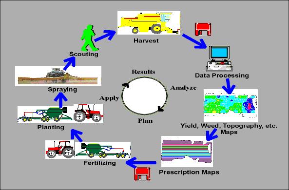
Figure 1. Precision farming cycle.
Several benefits are achieved from an automated method of capturing, storing and analyzing physical field records. Detailed analyses of the farm production management activities and results can be carried out. Farmers can look at the performance of new varieties by site specific area, measure the effect of different seeding dates or depths and show to their banker the actual yields obtained and the associated risk levels. It is imperative that trends and evaluations are also measured over longer time spans. Cropping strategies to control salinity may take several years to evaluate while herbicide control of an annual weed should only take one season. Precision farming can be approached in stages, in order to ease into a more complex level of management.
Precision farming allows for improved economic analyses. The variability of crop yield in a field allows for the accurate assessment of risk. For example, a farmer could verify that for 70 % of the time, 75 % of the barley grown in field "A" will yield 50 bushels. By knowing the cost of inputs, farmers can also calculate return over cash costs for each acre. Certain parts of the field which always produce below the break even line can then be isolated for the development of a site-specific management plan. Precision farming allows the precise tracking and tuning of production.
Precision farming makes farm planning both easier and more complex. There is much more map data to utilize in determining long term cropping plans, erosion controls, salinity controls and assessment of tillage systems. But as the amount of data grows, more work is needed to interpret the data and this increases the risk of misinterpretation. Farmers implementing precision farming will likely work closer with several professionals in the agricultural, GPS and computing sciences.
Where to start?
Precision farming does not "happen" as soon as one purchases a GPS unit or yield monitor. It occurs over time as a farmer adopts a new level of management intensity on the farm. Implicit in this is an increased level of knowledge of the precision farming technologies such as GPS. What is perhaps more important for the success of precision farming, at least initially, is the increased knowledge that a farmer needs of his natural resources in the field. This includes a better understanding of soil types, hydrology, microclimates and aerial photography. A farmer should identify the variance of factors within the fields that effect crop yield before a yield map is acquired. A yield map should serve as verification data to quantify the consequences of the variation that exists in a field. Management strategies and prescription map development will likely rely on sources other than yield maps. The one important key source of data a farmer should not start precision farming without is an aerial photograph.
By Tom Goddard, Conservation and Development Branch, Alberta Agriculture, Food and Rural Development
(Proceedings: Precision Farming Conference, January 20 - 21, 1997, Taber, Alberta, Canada) |
|