| |
Quantitative Morphometric Descriptions and Classification of Typical Alberta Landforms | |
| |
|
|
| |
|
|
| |
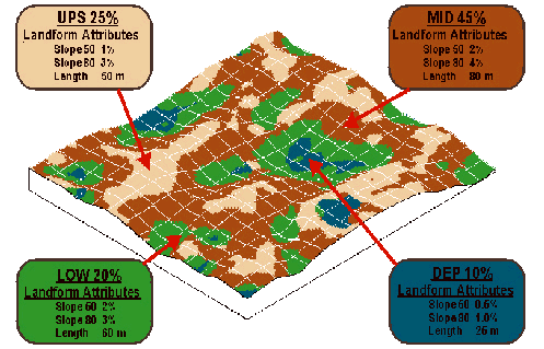
Most landscape related models need detailed, quantitative data about landform morphology
(e.g. slope length, gradient, relief) in addition to data about soil properties. Current soilsurvey
databases do not provide this kind of information.
This bulletin presents quantitative morphological descriptions and landform classifications for
typical glaciated landforms in western Canada and documents the methods used to produce
the descriptions. The analysis is based on high resolution DEMs (5-10 m spacing) for areas
of 100 to 200 ha in size (minimum of 1/4 section). The results are then related to 53 landform
types identified in the 1:100,000 soil survey database for Alberta, Canada. Morphometric
descriptions are provided for the landform as a whole and for 4 defined landform segments
(upper, mid, lower and depression) within each landform type.
The quantitative data provide necessary input for deterministic models and extend the utility
of the soil survey databases in Alberta.
 |
|
| |
|
|
| |
For more information about the content of this document, contact David Spiess.
This document is maintained by Laura Thygesen.
This information published to the web on December 16, 2005.
Last Reviewed/Revised on June 21, 2017.
|
|