| |
Forage Species | |
| |
|
|
| |
|
|
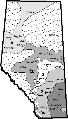
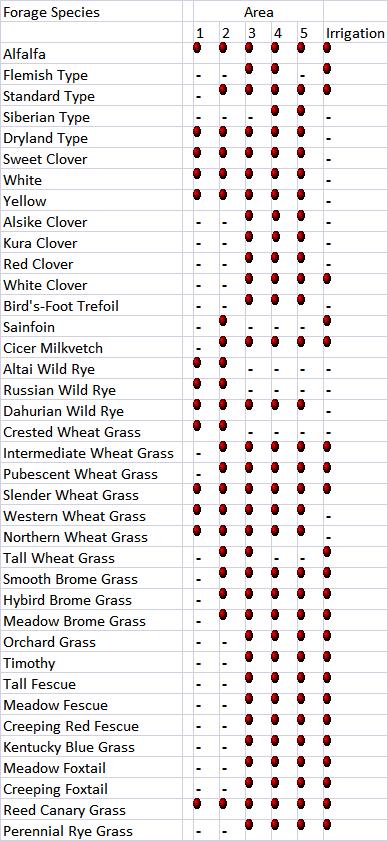
| | Forage soil and climatic zones of Alberta | Perennial forage species grown in Alberta adaptability matrix
Legumes
- are herbaceous plants with alternate broad leaves and stipules
- have growing points which are located at the tops of the plants
- have tap roots which can penetrate deep into the soil
Some legumes can produce growth from the original crown or from new crowns; however, unlike some grasses, they do not have the ability to increase stand density.
The most important feature of all legumes is the ability of the roots to supply nitrogen to the soil when inoculated with the proper nitrogen-fixing bacteria.
Grasses
- have hollow, jointed stems and a round or flattened cross section
- have long, flat or rolled leaves with parallel veins
- have root systems consisting of many fibrous roots growing from a central crown
- may have under ground stems (rhizomes) with nodes that can produce new shoots
- have an inflorescence (seed head) that is usually a spike (wheat-like) or a panicle (oat-like)
- usually have the growing point at the crown (soil surface) or a few centimetres above the soil surface
There are two main types of grasses:
- rhizomatous grasses - having creeping rhizomes and are sod forming
- bunch grasses - remain as individual plants
Forage Soil and Climatic Zones of Alberta
Area 1 - Brown Soil Climatic Zone
Climate/Vegetation:
- climate is semi-arid
- annual precipitation ranges from 300 to 350 mm (12 to 14 in)
- short grass prairie is the dominant native vegetation
- an area of low precipitation and high evapotranspiration causing a moisture deficit
Soil:
- the A Horizon of the soil profile is light brown in colour
- soil organic matter is normally less than 3 percent
- soil pH ranges from below 6.0 (acidic) in northern portions of the zone to over 7.5 (above neutral) in other areas
Area 2 - Dark Brown and Thin Black Soil Climatic Zone
Climate/Vegetation:
- includes the Dark Brown Soil Zone and the transitional Thin Black Soil Zone in Alberta
- annual precipitation ranges from 350 to 450 mm (14 to 18 in) and up to 525 mm (21 in) in the south-west corner
- mixed grass prairie and aspen parkland are the dominant native vegetation types
- drought is less frequent, generally there is sufficient moisture to support a tame forage crop
Soil:
- A horizon is dark brown to black in colour and ranges in depth from 17 to 25 cm (6 to 10 in),
- soil organic matter ranges from 3 to 5 percent
- soil pH ranges from 6.0 (slightly acidic) to 7.8 (slightly alkaline)
Area 3 - Black Soil Climatic Zone
Climate/Vegetation:
- encompasses the Black Soil Zone in Alberta
- annual precipitation ranges from 400 to 550 cm (16 to 22 in)
- area where native grassland is intermixed with deciduous forest to form the parkland
- some areas have been over grown by deciduous forest
- precipitation is adequate to permit continuous cropping of annual crops
- number of frost free days may limit the growing season
Soil:
- A horizon is black in colour and ranges in depth from 25 to 40 cm and greater (10 to 15 in)
- soil organic matter normally is above 5.0 percent
- the soil pH ranges from 6.0 to 7.5 (neutral = 7.0)
Area 4 - Gray Wooded Soil Zone
Climate/Vegetation:
- Central and Northern Alberta
- native vegetation is dominated by aspen and poplar interspersed with some spruce and pine and occasional small areas of open grassland
- annual precipitation can vary from 450 mm in the north to over 600 mm in the west-central area (18 to 23 in)
- soils have been supporting a mixed deciduous and coniferous forest for a long period of time
- frost free days and cooler temperatures limit the growing season and the range of crops which can be successfully grown
Soil:
- A horizon is relatively shallow ranging from 10 to 25 cm (4 to 10 in) and is a dark gray to an almost ash gray in colour
- soil organic matter originates from the forest leaves and ranges from 3 to 5 percent
- the soil pH ranges from acidic (<5.0) to near neutral (6.9)
Area 5 - Gray Wooded Soil Zone (Peace River Area)
Climate/Vegetation:
- the gray wooded soil zone in Northern Alberta lying north and west of Lesser Slave Lake and High Prairie
- low rate of evapotranspiration
- annual precipitation ranges from 400 mm to 550 mm (16 to 22 in)
- native vegetation ranges from a mixed deciduous and coniferous forest to parkland and areas of open prairie
- the growing season is relatively short; however this is offset by the long hours of daily sunlight during the growing season which compensates for the short growing season and fewer frost free days
Soil:
- A horizon can vary from 10 to 30 cm (4 to 12 in) in depth and ranges from a light gray to black in colour
- soil organic matter originates from the leaves of the deciduous forest and ranges from 2 to 4 percent
- the soil pH ranges from acidic (<5.0) to above neutral (7.5)
Area 6 - Irrigated Area, Southern Alberta
- lies within the Brown Soil Zone of Alberta; mainly in a triangle from Lethbridge in the southwest to Bassano in the north and Medicine Hat in the southeast
- has an extended, warm growing season, and marginal amounts of precipitation limit the crop production in the area
- through the use of irrigation the cropping potential of the area is optimized
- other characteristics are the same as the Brown Soil Zone

Perennial Forage Species Grown in Alberta Adaptability Matrix
The matrix is designed to assist in determining the species and type of forage best suited to an area, determine the forage climatic and soil zone for a specific location, and determine the forage species best suited for that location.

 = Adapted to the area = Adapted to the area
This information compiled by Bob Gould. |
|
| |
|
|
| |
For more information about the content of this document, contact Karin Lindquist.
This document is maintained by Marie Glover.
This information published to the web on June 16, 2005.
Last Reviewed/Revised on November 1, 2017.
|
|