| | Introduction | Signs of saline seep formation | Seep formation | Salinity classification | Salinity control
Introduction
Soil salinity can restrict plant growth and reduce crop yields. The high salt concentration in a saline seep prevents the uptake of water and essential nutrients by plant roots.
In Alberta, salts occur naturally in many bedrock deposits and in some deposits that lie on top of the bedrock. Groundwater flowing through these deposits dissolves and transports the salts. Under certain conditions, groundwater rises to the soil surface where the water evaporates, leaving the salts behind.
Over time, the salts accumulate on the soil surface. A white salt crust forms where the salt concentration is very high. Only salt-tolerant plants grow in this visibly saline area. The land around the visibly saline area will also have saline subsoil, resulting in reduced crop yields.
Various measures are used to control and reduce the flow of groundwater that leads to dryland saline seep formation. Many saline seeps can be controlled with low-cost methods. The cause of the saline seep determines which control method works best. This factsheet explains how saline seeps are formed, describes the types of dryland salinity found in Alberta and outlines recommended control measures.
Signs of Saline Seep Formation
Potential saline seeps can be identified many years before crop growth is severely affected. The early signs of seep development:
- a flush of crop growth combined with excellent crop yields
- increasing wetness, causing inaccessibility
- lush growth of weeds, particularly salt-tolerant weeds, in the fall in a mature crop. Common salt-tolerant weeds include kochia and foxtail barley.
As the saline seep grows, the early signs are followed by more obvious signs including:
- sparse germination of crop plants
- decreasing crop yields
- increasing numbers of salt-tolerant weeds
- salt crystals in the soil surface.
Seep Formation
Figure 1 shows a generalized diagram of saline seep formation. A saline seep is fed by one or more recharge areas. In a recharge area, water in excess of the water-holding capacity of the soil moves below the root zone. This movement raises the local water table, causing the groundwater to flow downslope. Groundwater flows through the subsoil or bedrock, and dissolves and transports salts in the soil. Eventually, the groundwater discharges near the soil surface. If the groundwater comes close enough to the soil surface, then capillary action and evaporation, which work like a wick in a kerosene lamp, draw the saline water to the soil surface (Figure 2). The water evaporates, leaving the salts behind. The salts gradually accumulate to form a saline seep.
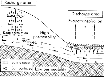
Figure 1. Generalized saline seep formation
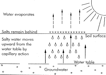
Figure 2. Salts build up by capillary action and evaporation.
There are three main types of groundwater flow systems: local, intermediate and regional. Groundwater in a local flow system travels a relatively short distance to its discharge area. Local systems commonly occur in areas with well-defined local relief (e.g. rolling landscapes). An intermediate flow system extends about 1 km from its recharge area and may consist of several interconnected local flow systems. Regional flow systems cover several kilometres and occur in areas with one large slope or in large valleys.
Salinity Classification
Alberta Agriculture has classified saline seeps based on their cause. The cause of the seep determines which control measures are appropriate. The seven types of dryland soil salinity found in Alberta are described below.
It can be difficult to classify a saline seep correctly without detailed information on geology, soils, land forms, surface water flows and hydrogeology. Also several causes can influence the formation of a saline seep, making it difficult to determine the dominant cause.
However, Alberta Agriculture has mapped the salinity types in many Alberta municipalities. If a salinity map is available for your municipality, the agricultural fieldman will have a copy. If no salinity map is available, then contact an Alberta Agriculture salinity specialist to determine the salinity type(s) on your land and develop a conservation plan to control salinity.
Contact salinity
In a contact saline seep, groundwater flows in a permeable layer above a less permeable (e.g. fine-textured) layer until the permeable layer thins out (Figure 3). This forces the groundwater flow close to the soil surface. The water rises to the soil surface, evaporates and a saline seep forms.
Figure 3. Contact salinity
Slope-change salinity
In this salinity type, shown in Figure 4, groundwater flows in a permeable surface layer above a less permeable layer until the surface slope decreases. This forces the groundwater close to the soil surface. The water rises to the soil surface, evaporates and a saline seep forms. Slope-change seeps tend to expand upslope.
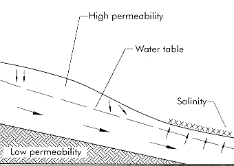
Figure 4. Slope-change salinity
Outcrop salinity
Outcrop salinity occurs where a permeable, water-bearing layer, such as a coal seam or fractured bedrock layer, outcrops at or near the soil surface (Figure 5). Outcrop saline seeps often occur in rows along a slope at similar elevations.
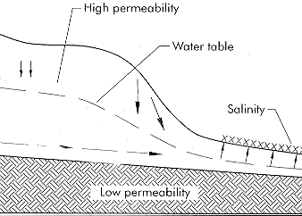
Figure 5. Outcrop salinity
Artesian salinity
Artesian salinity occurs where water from a pressurized aquifer rises to or near the ground surface (Figure 6). This type of salinity is usually associated with intermediate or regional groundwater flow systems. If the pressure is large enough, the water flows to the surface and produces a flowing well, spring or soap hole. These features are used in combination with hydrogeological maps to identify artesian salinity.
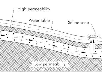
Figure 6. Artesian salinity
Depression bottom salinity
This type of salinity, shown in Figure 7, occurs in depressions and watercourses. Water flows over the ground surface and temporarily ponds in low lying areas. Gradually, the ponded water drains away or infiltrates into the soil. Groundwater at the edge of the pond moves upslope through the upper soil layer and rises to the soil surface and evaporates. Once the surface water has disappeared, water from the water table rises to the soil surface in the previously ponded area. On air photographs, depression bottom seeps are well-defined with distinct, rounded edges. This type of salinity is very common in Alberta. It occurs in landscapes with poor drainage, particularly in rolling and hummocky areas.
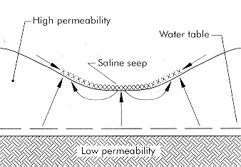
Figure 7. Depression bottom salinity
Coulee bottom salinity
Coulee bottom salinity forms in the bottoms of coulees and watercourses by the same mechanism as depression bottom salinity but on a larger scale. This salinity type is common in southern Alberta where the landscape is dissected by numerous coulees and their tributaries.
Slough ring salinity
This type of salinity occurs as a ring of salt immediately around a permanent water body (Figure 8). Some water infiltrates from the water body into the permeable upper soil layer and moves upslope. Water from the upslope flow and water from the water table rise to the soil surface and evaporate, leaving salts behind. This salinity type is very common in central Alberta.
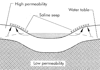
Figure 8. Slough ring salinity
Salinity Control
Biological and structural methods are used to control soil salinity. Generally, structural controls work faster than biological controls to lower water tables and improve accessibility in discharge areas. However, structural controls are usually more expensive than biological controls and are not always totally effective. Even more importantly, their use usually requires a licence from Alberta Environment because of their potential environmental impact.
Biological controls
In recharge areas of contact and slope-change seeps, crops are grown to intercept excess soil water before it moves below the root zone. These measures control and reduce saline seeps.
In the discharge areas of all salinity types, salt-tolerant perennial grasses are grown to provide soil cover and shading, reducing evaporation that, in turn, reduces the rise of salty water to the soil surface. These grasses help to stabilize a saline seep, but on their own, they cannot bring a saline seep back into annual crop production. Growing grasses in seeps is only possible when the salt concentration is not so high as to completely prevent all plant growth.
Structural controls
In discharge areas, surface and subsurface water management or relief wells are sometimes used to control saline seeps if conditions are appropriate. In recharge areas, surface water management may be used if ponding is a problem.
These salinity control measures are discussed in more detail in the other factsheets in this series: Agdex 518. The measures are summarized in Table 1.
Table 1. Salinity types and recommended control measures
Salinity type | Control |
| Contact salinity | Salt-tolerant grasses in the saline area and alfalfa in the upslope dominant recharge area |
| Slope-change salinity | Salt-tolerant grasses in the saline area and alfalfa in the upslope dominant recharge area |
| Outcrop salinity | Salt-tolerant grasses in the saline area; subsurface water management if appropriate |
| Artesian salinity | Salt-tolerant grasses in the saline area; relief wells connected to suitable outlets |
| Depression bottom salinity | Salt-tolerant grasses in the saline area and along the edge of the depression in a band extending an additional 20 to 60 m beyond the visibly saline area; appropriate surface water management |
| Coulee bottom salinity | Salt-tolerant grasses in the saline area; appropriate surface water management |
| Slough ring salinity | Salt-tolerant grasses in a band around the slough in the visibly saline area and extending an additional 20 to 60 m beyond; appropriate surface water management |
For more information on salinity control, contact the Alberta Agriculture and Food Ag-Info Centre at 310-FARM (3276).
Prepared by:
Donald Wentz, formerly with Alberta Agriculture and Food.
Source: Agdex 518-12. Revised January 2000. |
|