| | Formulation of clear goals provides a destination, but not the route to achieve them. The next step is to gather information and develop a map or model of the factors that control desired outcomes (Figure 2).
. .
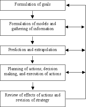
Figure 2. Steps in the organization of complex action (from Dörner 1996, p. 43)
Models are representations of the current understanding of a phenomenon or process of interest (Addiscott 1993; Yaalon 1994). Of necessity, they are simplifications of reality. Three types of models are often recognized. Stochastic models describe the relationship among variables using best-fit stochastic coefficients, without consideration of causal relationships. Functional models describe the relationship among variables using the simplest description of causal relations possible that still provides a useful description of the process or phenomenon. Mechanistic models describe the relationship among variables using only the most elementary description of causal relationships possible. As an example, the braking system of a car can be modelled using each of these approaches (Dörner 1996). A stochastic model would describe the braking system as the relationship between pressure on the brake pedal and deceleration of the car. A functional model would describe the components of the braking system and how they interact to slow the car. A mechanistic model would describe the properties of the materials contained in the components of the braking system. The appropriate description depends on the use. A stochastic model may be sufficient for a driver to operate the car, while a functional model would be required for a mechanic to maintain the braking system and a mechanistic model would be required by an engineer to design improved brake systems.
Gathering information and formulating models are activities that may never be completed, particularly if you are a scientist, due to the infinite depth and detail it is possible to go into. The challenge is to aggregate sufficient information so that reasonably sound action plans can be developed, given the constraints of time and money that limit efforts in this area.
The initial information requirement is identification of the variables controlling outcomes and the interrelationships of these variables. For example, variables controlling the quality of runoff water include precipitation, topography, land cover, and soil nutrients. Information is also required on the driving forces that impact the variables controlling outcomes, such as the economic forces affecting the choice of tillage system or nutrient application rate. Finally, information is required on the type and effectiveness of responses that could be used to achieve goals, such as the use of buffer strips, the maintenance of soil-available nutrients below a specified level, appropriate manure and fertilizer application methods, and development of environmental farm plans. This driving force-outcome-response framework (or pressure-state-response framework) is widely used in environmental assessment (e.g., McRae et al. 2000).
Challenges exist even when information is available. System complexity limits our ability to accurately determine the barriers to desired outcomes. Relationships among variables are often non-linear and buffered to various degrees, making it difficult to predict responses. Goals conflict with each other due to negative correlations among variables controlling outcomes. It is also more difficult to achieve multiple goals than simple goals, and multiple goals require more sophisticated solutions. The achievement of goals requires expertise in a large number of subjects.
Complexity is also increased due to the wide range in scale of issues related to soil functions. Scale refers to the time or distance over which a phenomenon exists or cycles (Blöshl and Sivaplan 1995). For example, soil taxa at the level of order or great group exist over distances of hundreds of kilometres and are the product of centuries or millennia of pedogenic processes. In contrast, the soil rhizosphere only exists within a few millimeters of the root surface and undergoes rapid changes within periods of even a few hours. In general, phenomena that occur at large temporal scales also occur at large spatial scales.
The temporal and spatial scales of soil processes extend over ten orders of magnitude (Ellert et al. 1997). These are scales of natural phenomena and beyond our control. In contrast, observations of soil processes can be made at different scales, within limits set by resources and instrumentation. Observation scale is defined by the spatial or temporal extent of sampling (coverage), spacing between samples (resolution), and integration volume of a sample (Blöshl and Sivaplan 1995). Processes that occur at scales larger than the observation scale appear as trends in the data, while processes that occur at scales smaller than the observation scale appear as noise. Modelling represents another activity that can be conducted at different scales. Modelling scale is usually selected based on the scale of the process and the application for which the model is to be used. Finally, management occurs at a range of spatial (field, farm, watershed, ecoregion, etc.) and temporal (seasonal, annual and multi-year) scales.
Potential problems occur when observations and models determined at one scale are used for processes or applications at a different scale. Observations or models obtained at a small scale may be inappropriate to make conclusions at a large scale due to higher level interactions, lack of appropriate data for model validation, high cost of data collection and analysis, and low value of information due to increased complexity (Blöshl and Sivaplan 1995). For example, estimates of the contribution of soil erosion to poor water quality based on estimates of soil erosion from hill slopes may be inaccurate due to factors that control the proportion of soil erosion that enters a watercourse. Observations or models obtained at a large scale may be inappropriate to make conclusions at a small scale due to the difficulty in disaggregating large-scale values. For example, an estimate of soil erosion for a particular field based on regional estimates may be inaccurate because it does not reflect the factors controlling soil erosion in that particular field. |
|