| | Agricultural contaminants in groundwater | Geology and groundwater in Alberta | Aquifers and aquicludes | General indications of aquifer vulnerability | Information sources for estimating groundwater vulnerability in Alberta | Interpreting information sources | Recommendations
The majority of rural Albertans rely on groundwater for their domestic water supply. However, studies indicate between 20% and 40% of rural wells in Canada have nitrate concentrations or coliform bacteria occurrences in excess of drinking-water guidelines. Studies in Alberta have shown groundwater supplies vary widely in their susceptibility to contamination from surface sources. Shallow groundwater sources in irrigated areas of southern Alberta are particularly vulnerable to contamination and can transport contaminants to surface water bodies. General information that will help land managers understand the risks to their groundwater sources is available, but site-specific investigations by specialists are needed to more accurately determine groundwater vulnerability for any particular location. Albertans can help maintain the quality of this valuable resource by taking extra precautions over the most vulnerable groundwater supplies.
Agricultural Contaminants in Groundwater
Groundwater contaminants can originate from industry, domestic activities and agriculture. Fertilizer and manure are beneficial to soils and crops, but have the potential to contaminate groundwater with nitrate, phosphorus, salts and pathogens. Such contamination usually occurs when these substances are improperly stored, or applied at rates greater than crops require. Pesticides are another potential agricultural contaminant.
Geology and Groundwater in Alberta
The first sediments encountered below ground surface are usually surficial, unconsolidated sediments, deposited during or after the last glaciation. These surficial sediments can include clay, silt, sand, gravel, and till. Till is made up of predominantly clay-sized particles with some larger rock fragments.
Surficial sediments are underlain by layers of harder bedrock. Bedrock in most of Alberta was deposited in deltas and shallow seas about 75 million years ago and includes shale, siltstone, sandstone, mudstone, claystone and coal. The top of the bedrock in Alberta can occur anywhere from ground surface to more than 100 metres below ground level. In some locations, pre-glacial or buried-valley sand and gravel deposits occur between till and bedrock. These sands and gravels were deposited by rivers flowing from the mountains before the last glaciation. They form a vast network of inter-connected, underground valleys throughout Alberta, and can be more than 16 kilometres wide.
Groundwater is found in the pore spaces of underground sediments and rocks. The water table is the upper surface of the saturated or groundwater zone. In Alberta, it often occurs within the top five metres below ground surface, although the water table is often deeper in topographically higher areas. The layers of soil and rock below the water table vary widely in their ability to transmit groundwater. Aquifers are water-bearing geologic layers that yield significant amounts of water. Aquicludes are water-bearing layers in which the water moves so slowly it cannot supply a household.
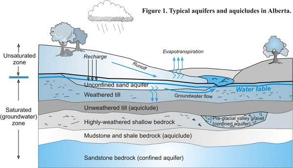
A portion of the water that falls on the ground surface, whether as precipitation or water from irrigation, infiltrates through the soil zone to the water table where it becomes part of the groundwater. This process is called recharge. Most recharged groundwater flows laterally within the top few metres below ground. Some of this recharged water is used by plants, and some flows into surface water bodies such as streams, lakes or sloughs. In this way, shallow groundwater can carry contaminants to surface water.
Aquifers and Aquicludes
Sand and gravel deposits are usually aquifers, provided they are located below the water table and are of sufficient thickness. Sand and gravel layers can occur at surface, buried within till, or as pre-glacial river valley deposits between the till and bedrock. The top four to six metres of glacial till is usually highly weathered and fractured. These fractures allow water to move more quickly through shallow, weathered till and clay than through deeper, unweathered till and clay. Therefore, thick tills are much more effective aquicludes than thin tills. Many bedrock layers in Alberta are neither good aquifers, that produce abundant groundwater, nor good aquicludes, through which groundwater flow is negligible. Rather they fall somewhere in between. Bedrock layers that are fractured or coarse-textured (for example, sandstone) produce more groundwater than layers that are unfractured or fine-textured (for example, shale). Coal layers are usually aquifers.
General Indications of Aquifer Vulnerability
Confined aquifers are those overlain by geologic deposits that have low permeability. The confining layer helps to protect them from contamination. Unconfined aquifers are those that occur near the surface, without a protective layer between the water table and the ground surface.
Studies show shallow, unconfined aquifers are highly susceptible to agricultural contamination. A sand or gravel aquifer that occurs immediately below ground surface is extremely vulnerable, because water from the surface travels into it very quickly. If the water contains agricultural contaminants, these will also enter the groundwater. In contrast, bedrock and surficial aquifers that are buried by 30-metre thick deposits of unfractured clay, till or shale have a very low vulnerability to surface contamination. This is because recharged groundwater generally requires more than 1000 years to travel to the aquifer. Drift, clay and boulders, clay and gravel, clay and rocks, clay and silt are descriptions used by well drillers to indicate till. Drift, clay and boulders, clay and gravel, clay and rocks, clay and silt are descriptions used by well drillers to indicate till.
Shallow geologic layers, including sand and gravel, fractured or coarse-textured till, and shallow weathered bedrock, may be too thin to act as good aquifers. However, they can transport groundwater and contaminants off-site. Even if they are not usually saturated, they can transport groundwater off-site during rainstorms and spring snow-melt.
Note: Drift, clay and boulders, clay and gravel, clay and rocks, clay and silt are descriptions used by well drillers to indicate till.
Information Sources for Estimating Groundwater Vulnerability in Alberta
Only a site-specific investigation involving drilling can accurately determine relative groundwater vulnerability at a specific location. However, land managers can obtain general information on their groundwater from water-well descriptions, called well logs, available from Alberta Environment’s Groundwater Information Center (GIC) database. To obtain a well log, contact the Water Data Management Section of Alberta Environment in Edmonton at 780-427-2770. (You may reach any Alberta government office toll-free by dialing 310-000.)
Another source of information on local groundwater conditions are the Regional Groundwater Assessment Reports, prepared by the Prairie Farm Rehabilitation Administration (PFRA) of Agriculture and Agri-Food Canada. These reports are based on a regional assessment of GIC data. They provide information on the yield, quality and depth of aquifers. The information can be searched by legal land location. A map showing municipalities with completed or in-progress studies can be viewed free of charge here. The reports (without maps) can be downloaded at no charge from the same website. To obtain complete reports and databases, contact your local municipality.
The Agricultural Region of Alberta Soils Information Database (AGRASID) is a standardized compilation of all soil survey information for the province. It portrays soils, surficial geology, landforms and depth-to-bedrock data at a scale of 1:100,000, with links to information such as soil texture and drainage. AGRASID can be downloaded at no charge from here or by following the links from Alberta Agriculture’s website.
Surficial Geology Maps, prepared by I. Shetsen (1987) are available for southern and central Alberta. These maps show the geology of the top few metres below ground, on a scale of 1:500,000. Copies of the maps can be purchased for $20.00 each from the Alberta Geological Survey in Edmonton. To order, phone 780-422-3767 or e-mail your request to EUB.AGS-Infosales@gov.ab.ca. Digital versions of the maps are available from the same source.
Water Wells That Last For Generations contains information on maintaining and protecting wells. The manual is available from Alberta Agriculture and Rural Development, PFRA, and Alberta Environment.
Interpreting Information Sources
Groundwater in irrigated locations and those receiving greater rainfall are usually more susceptible to contamination than arid and non-irrigated locations. Hummocky landscapes can promote recharge in low areas, while precipitation is more likely to run off the land surface in uniformly-sloping landscapes. Information on landscape properties can be obtained from AGRASID.
In general, it can be assumed that the deeper an aquifer is, or the thicker the unfractured till, clay or shale above a potential aquifer, the more protected the aquifer is from contamination. The most vulnerable aquifers are those that occur near the surface. Areas with aquifers near the surface can be identified from surficial geology maps (Table 1) and AGRASID. Deep aquifers buried by thick deposits of unfractured clay, till or shale have a very low vulnerability to surface contamination. However, even deep wells can be contaminated at the well head, and be vulnerable to contamination if they have long screened intervals that extend close to the surface. Areas with relatively thick till are also identified on soils and geology maps.
Information on the thickness and type of sediments at a specific location can be obtained from the GIC database, provided well logs are available for that location.
Though few bedrock layers are a single texture, the dominant texture is usually listed in well logs. Shale is commonly considered an aquiclude, and sandstone and coal are usually considered aquifers, but many aquifers are composed of fractured shale, and many aquicludes are composed of bentonitic or cemented sandstone. The most useful well logs provide information on the relative permeability of the surficial or bedrock layers (Table 2).
In many cases, the depth where the majority of groundwater enters a well is not clear from a well log. Drillers may drill beyond the main water-bearing layers in an attempt to obtain additional water. However, the presence of shallow water wells listed in the GIC database generally indicates the presence of relatively shallow and vulnerable aquifers. Information on well depth can be useful in areas with few geologic descriptions. Regional groundwater assessment reports are also useful for determining aquifer locations.
The uppermost few metres of bedrock are often highly weathered and permeable. Even if the fractured bedrock surface is not an aquifer, it can still promote off-site groundwater transport. Depth to bedrock can be obtained from well logs, and from completed Regional Groundwater Assessments. Locations with bedrock shallower than five metres are mapped in AGRASID.
Information on the effects of agricultural contaminants on groundwater quality is also available on other fact sheets published by Alberta Agriculture and Rural Development. Fact sheet IB004-2002 for example, addresses the subject of groundwater quality in the Battersea Drain.
Recommendations
Land managers can help protect their groundwater supply by understanding risks, and taking extra precautions in more susceptible areas. To determine whether vulnerable areas exist in a particular location, site-specific investigations should be conducted. Deep aquifers generally have a low susceptibility to contamination, but deep wells should be carefully sealed and protected to prevent local contamination at the wellhead. Wells should only be screened in aquifers, with impermeable seals placed between the aquifer and ground surface. Fertilizer and manure should be applied only at rates crops require, especially in areas with shallow aquifers. Confined Animal Feeding Operations in such vulnerable locations may require more costly solutions for groundwater protection. Land managers can assess their approximate groundwater vulnerability as part of an Environmental Farm Plan.
This fact sheet on Groundwater Vulnerability in Alberta is one of a series of information bulletins on agriculture and resource management produced by the Irrigation Branch, Alberta Agriculture and Rural Development.
For more information, contact Rod Bennett of the Irrigation Branch at 403-381-5880 or use the Alberta Government Riteline, toll-free, 310-0000. |
|