| | The Crowfoot Creek Study was conducted to determine whether agricultural practices are contributing to the deterioration of surface water quality in the watershed and to identify specific land uses having an impact. Water quality was monitored at 28 sites over a four-year period. Results indicated levels of total phosphorus exceeded water quality guidelines most of the time, but were highest during spring runoff. Levels of total nitrogen exceeded the guidelines mainly during spring runoff and rainfall events. Fecal coliform bacteria counts exceeded irrigation and contact recreation guidelines for much of the year and appeared to be related to the presence of cattle in the watershed. Guidelines for total dissolved solids were exceeded from spring runoff through early summer, and during rainfall events.
.
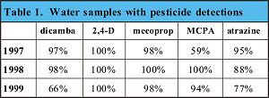
Manganese and iron concentrations exceeded some guidelines during spring runoff. Of 25 pesticides monitored, dicamba, 2,4-D and MCPA appeared consistently and exceeded irrigation guidelines during part of the monitoring period.
Why was this study conducted?
Alberta’s agricultural industry is under increasing pressure to remain globally competitive, while providing responsible stewardship of natural resources. However, recent studies have documented the presence of agriculturally-derived contaminants in both surface and ground water in Alberta, especially in intensively farmed areas.
Crowfoot Creek is a small tributary of the Bow River, in an area of intensive agricultural activity. It was selected as the location for this detailed study in response to the concerns of area residents and findings of previous studies that identified high concentrations of nutrients and coliform bacteria in the watershed. Agricultural inputs of fertilizers and herbicides in the region are in the top 25th percentile in Alberta.
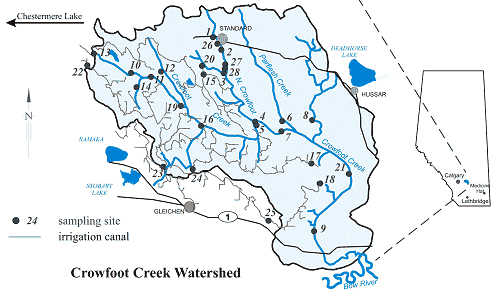
The area was also a good site for this study as only one village, Standard, lies within the basin. There were also many suitable and easily accessible sites for monitoring stations to be installed. A long term flow monitoring station was already located at Site 9, at the outlet of the basin. A constant flow of water at the monitoring stations was provided at the majority of sites by spill water from the Western Irrigation District (WID) and runoff from snowmelt occurs in most years.
How was this study conducted?
Monitoring equipment was located at 28 sites, selected on the basis of land use and consultations with farmers and partners in the project. Sites 1 through 12, 19 through 21, and 26 through 28 were located on Crowfoot Creek and its tributaries. Sites 13 through 18 were selected to represent high flow deliveries of water from WID return flows into Crowfoot Creek. Sites 22 through 25 were selected to monitor the quality and quantity of water flowing into the watershed via the WID infrastructure.
Flow volume was determined at all sites using stage-discharge curves developed from water depth and flow velocity data. Water depth data were colledted using stilling wells and dataloggers or staff gauges. Flow velocity data were collected through flow metering of watercourses throughout the year. Over a four-year period from 1996 to 1999, water samples were taken weekly at all sites from early May to late October. Sampling was conducted daily during snowmelt and selected rainfall events.
Samples were analysed for nitrate, nitrite, ammonia, total Kjeldahl nitrogen, and total and dissolved phosphorus. Salinity analyses were conducted for soluble cations and anions, pH, electrical conductivity, and total suspended solids. Bacterial analyses were conducted for coliforms and E. coli. Three samples a year from each site were analyzed for soluble trace elements. Testing for 25 commonly used pesticides was conducted at six sites over an 8-week period during the spraying season.
A map of the land cover in the watershed, including native and improved pasture, perennial forages, annual crops, and summerfallow, was prepared using satellite imagery, and was added as a layer to a geographical information system (GIS) of the watershed . Other layers included watershed features, soil types, topography, irrigated and dryland areas, and the irrigation district distribution system.
What did we learn?
Results from this field study indicate four major areas of concern:
- high levels of total nitrogen (TN)
- high levels of total phosphorus (TP)
- high levels of fecal coliform bacteria
- high levels of dicamba, 2,4-D and MCPA.
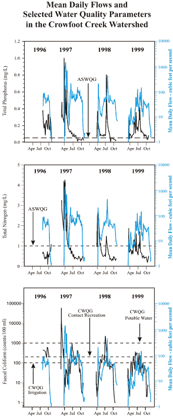
The concentration of TN at Site 9, where the water leaves the Crowfoot Creek watershed, met Alberta Surface Water Quality Guidelines (ASWQG) of 1.0 mg L-1 during most of the study period. However, TN exceeded SWQG during spring runoff and rainfall events. Levels of TP exceeded the ASWQG of 0.05 mg L-1 most of the time, and were highest during spring snowmelt and rainfall events. Fecal coliform bacteria counts exceeded the Canadian Water Quality Guidelines (CWQG) for irrigation (100 counts 100 ml-1) and for contact recreation (200 counts 100 ml-1) often during the monitoring period. Fecal coliform bacteria counts, with the exception of some peaks, were low in the spring and increased until early summer. Counts remained fairly constant until early fall when they again decreased. Counts increased sharply during rainfall events, and also occasionally during non-event periods.
Coliform bacteria counts appeared to be related to the presence of cattle in the watershed. Increasing values during early summer corresponded with increased cattle numbers near the creek; lower autumn counts were related to the removal of cattle from creekside grazing areas.
Five herbicides were detected consistently in the watershed. (See Table 1) The concentrations of dicamba, MCPA and 2,4-D were higher at Sampling Site 9 than at sampling stations where the water enters the basin. No irrigation guideline has been set for 2,4-D, but MCPA and dicamba concentrations exceeded the CWQG for irrigation of 0.025 micrograms per litre and 0.006 micrograms per litre, respectively, during most of the sampling period. These herbicide concentrations could have negative impacts on crops irrigated with this water. Concentrations of mecoprop and atrazine were lower leaving the watershed than entering it, indicating these herbicides came from upstream sources.
Other parameters of concern are the sodium adsorption ratio (SAR), electrical conductivity (EC), total dissolved solids (TDS) and trace metals. SAR and EC exceeded CWQG for irrigation during spring runoff and rainfall events. TDS levels exceeded irrigation guidelines during the spring, early summer, and during rainfall events. TDS only rarely exceeded livestock drinking water guidelines, which are less stringent. Elevated springtime levels of SAR, EC, and TDS were likely the result of groundwater inputs over the winter. Some areas of saline soils adjacent to the creek may also contribute to high salinity levels.
Manganese and iron levels tended to exceed the CWQG for irrigation in the spring. Mercury levels exceeded the CWQG for freshwater aquatic life some of the time and do not appear to increase within the watershed. The presence and concentration of mercury and other soluble trace metals were likely influenced by naturally-occurring groundwater.
Land cover effects were difficult to ascertain. Grasslands adjacent to the watercourse appeared to be better at reducing the amount of particulate P in streams when contrasted with areas of annual crop or summerfallow located there. However, grazed areas were also likely sources of fecal coliform bacteria.
What’s being done?
In response to the study results, the Crowfoot Creek Watershed Group was formed in January 1999. The group is working toward the adoption of better agricultural management practices, so water leaving the basin will be of equal or better quality than water entering it. The group is comprised of local agricultural producers and residents, and is based in the village of Standard. Members work in partnership with local, provincial and federal government stakeholders to increase community awareness of water quality issues.
Crowfoot Creek Watershed Group initiatives include a survey to identify the concerns of landowners in the region. Beneficial management practices demonstration sites have been established to increase awareness of what can be done.
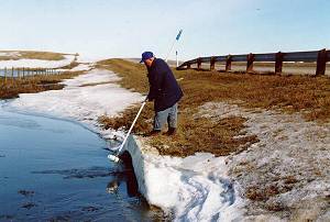
Members of the Crowfoot Creek Watershed Group gather at a Beneficial Management Practices demonstration site.
Water Quality Guidelines
Water quality guidelines recommend maximum limits for various substances and conditions which may be found in water supplies. These parameters include nutrients, pesticides, bacteria and pathogens, metals, salts, pH, suspended solids, temperature and turbidity.
Guidelines are suggested for specific uses, including human drinking water, water for recreational activities, for the
protection of freshwater aquatic life, and for irrigation and livestock watering. Maximum allowable concentrations in
the guidelines typically provide a protection factor of 10 to 100 times the identified safe limits.
In Canada, human drinking water guidelines are set by the federal government and apply to water used for all
domestic purposes, including cooking, personal hygiene and laundry. They are based on current scientific knowledge of human health and assume life-long use of the water being tested. They also assume water for domestic supplies is properly treated.
Surface water quality guidelines for use in Alberta are set by the provincial government. A new set of guidelines
issued in November 1999 focuses on agricultural, recreational and aesthetic objectives and the protection of
freshwater aquatic life.
The guidelines for livestock drinking water are based on regular use of the water supply for domestic animals, and on human health concerns related to the consumption of the livestock. The guidelines for water applied to irrigated crops are based on knowledge of crop reactions to regular use of the water.
Recreational guidelines are based largely on the microbiological content of surface water bodies used for contact
activities.
Guidelines for the protection of freshwater aquatic life are set to ensure the survival of native plants and animals that live in or near surface water bodies and to sustain their natural aquatic ecosystems. |
Acknowledgments
Funding for this study was provided from the Matching Grant Program of the Alberta Agricultural Research Institute (AARI).
- Partners and contributors for the Crowfoot Creek study included: Alberta Agricultural Research Institute
- Alberta Agriculture and Rural Development
- Wheatland County
- Ducks Unlimited Canada
- Western Irrigation District
- Village of Standard
- Alberta Environment
- Provincial Laboratory for Public Health
- PFRA
- University of Alberta
- Eastern Irrigation District
- Siksika Nation
- McGill University
- Local producers

This fact sheet on the Crowfoot Creek Watershed Study is one of a series of information bulletins on agriculture and resource management produced by the Water Resources Branch, Alberta Agriculture and Rural Development. For more information, contact Gerald Ontkean, Water Resources Branch, at (403) 381-5891 or use the Alberta Government Riteline, toll-free, 310-0000.
IB006-2000 |
|